Current Weather/Notams (Metars, TAFs, Notams, NWS Forecast, PIREPS, and nearby weather)
Customs Information Send updates to Support@FltPlan.com
Customs Not Available
Database effective 05/16/2024
Airport Diagram might not be current.
|
| Facility Name: | FORT MADISON MUNI |
| City Name: | FORT MADISON |
| County: | LEE |
| State abbrev: | IA |
| State Name: | IOWA |
| | |
| Ownership: | PUBLICLY OWNED |
| Use: | OPEN TO THE PUBLIC |
| Owner's Name: | CITY OF FORT MADISON; BOB CHESNUT CHMN ARPT CMSN; CALL 319-470-0066. |
| Address: | AVE E & 8 TH |
| | FORT MADISON, IA 52627 |
| Owner's Phone: | 319-372-7700 |
| | |
| Manager's Name: | DAVE WOODLEY |
| Address: | 50 ARPT RD. |
| | FORT MADISON, IA 52627 |
| Phone: | 319-372-1138 |
| | |
| FAA Region: | CENTRAL |
| FAA Field Office: | NONE |
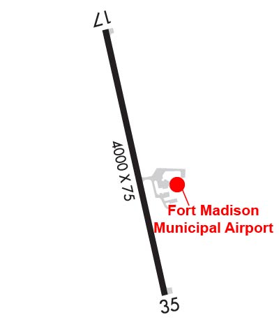
Runway Identifications
Runway Identification: 17/35Length: 4000 ft
Width: 75 ft
Surface: CONCRETE-GOOD CONDITION
Edge lights: Medium IntensityTreatment: WIRE COMB OR WIRE TINE
Weight: PCN 9 /R/C/W/U
| | Runway: 17 | | Runway: 35 |
| Mag heading: | 167° | Mag heading: | 347° |
| Rwy Slope: | .06% Up | Rwy Slope: | -.06% Down |
| Approach: | | Approach: | |
| Pattern: | Right Traffic | Pattern: | Left Traffic |
| Markings: | NONPRECISION INSTRUMENT | Markings: | NONPRECISION INSTRUMENT |
| Marking Condition: | GOOD | Marking Condition: | GOOD |
| Arresting Dev: | | Arresting Dev: | |
| Lat & Long: | N4039.9 W09119.8 | Lat. & Long.: | N4039.2 W09119.6 |
| Elev: | 713.0 ft. MSL | Elev: | 715.2 ft. MSL |
| TCH: | | TCH: | 28 ft. AGL |
| Visual Glide Path: | | Visual Glide Path: | 3.00 degrees |
| Displaced Threshold: | No | Displaced Threshold: | No |
| Touchdown Zone: | YES | Touchdown Zone: | YES |
| Touchdown Elev.: | 721.8 feet | Touchdown Elev.: | 721.8 feet |
| Visual Glide Slope: | | Visual Glide Slope: | 2-Light PAPI on LEFT side of Runway; RWY 35 PAPI UNUSBL BYD 6 DEGS LEFT OF CNTRLN AND BYD 8 DEGS RIGHT OF CNTRLN. |
| RVR Equipment: | | RVR Equipment: | |
| RVV Equipment: | NO | RVV Equipment: | NO |
| Approach Lights: | | Approach Lights: | |
| REIL: | NO | REIL: | YES |
| Centerline Lights: | NO | Centerline Lights: | NO |
| Touchdown lights: | NO | Touchdown lights: | NO |
| Runway Category: | Runway with a Non-precision Approach having visibility minimums greater than 3/4 mile | Runway Category: | Runway with a Non-precision Approach having visibility minimums greater than 3/4 mile |
| Declared Distances: | | Declared Distances: | |
| Obstructions: | TREES | Obstructions: | TREES; +33 FT TREES 1000 FT L/R. |
| Marked: | NOT Marked/Lighted | Marked: | NOT Marked/Lighted |
| Clearance slope: | 22:1 | Clearance slope: | 20:1 |
| Obstruction height: | 40 feet AGL | Obstruction height: | 25 feet AGL |
| Dist. from runway: | 1100 feet | Dist. from runway: | 702 feet |
| Centerline offset: | 225 right of centerline | Centerline offset: | |
| Comments: | | Comments: | |