
| ||||||||||||||||||||||||||||||||||||||||||||
| ||||||||||||||||||||||||||||||||||||||||||||
| ||||||||||||||||||||||||||||||||||||||||||||
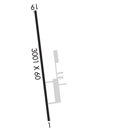
| Rwy | Rwy | |||||||
| 3001x60 | 3001' | 3001x60 | 3001' | |||||
| Runway ID | Single Wheel | Double Wheel | Double Tandem Wheel | Dual Double Wheel |
| 01/19 | 12,500 | N/A | N/A | N/A |
| These numbers are Advisory and are not limits. The Airport Manager should have more accurate Weight Limits | ||||
 Airport Diagram might not be current. | |
| Facility Name: | FRANKLIN COUNTY STATE |
| City Name: | HIGHGATE |
| County: | FRANKLIN |
| State abbrev: | VT |
| State Name: | VERMONT |
| Ownership: | PUBLICLY OWNED |
| Use: | OPEN TO THE PUBLIC |
| Owner's Name: | STATE OF VERMONT |
| Address: | 219 N MAIN ST |
| BARRE, VT 05641 | |
| Owner's Phone: | 802-279-2647 |
| Manager's Name: | ROLLIN TEBBETTS |
| Address: | 219 N MAIN ST |
| BARRE, VT 05641 | |
| Phone: | 802-585-5586 |
| FAA Region: | NEW ENGLAND |
| FAA Field Office: | NONE |
| Date | Sunrise | Sunset |
|---|---|---|
| 04/23/24 Tuesday | 5:53 | 19:49 |
| 04/24/24 Wednesday | 5:51 | 19:50 |
| 04/25/24 Thursday | 5:50 | 19:51 |
| 04/26/24 Friday | 5:48 | 19:53 |
| 04/27/24 Saturday | 5:47 | 19:54 |
| 04/28/24 Sunday | 5:45 | 19:55 |
| 04/29/24 Monday | 5:44 | 19:56 |
| 04/30/24 Tuesday | 5:42 | 19:58 |
| 05/01/24 Wednesday | 5:41 | 19:59 |
| 05/02/24 Thursday | 5:39 | 20:00 |
| 05/03/24 Friday | 5:38 | 20:01 |
| 05/04/24 Saturday | 5:36 | 20:02 |
| 05/05/24 Sunday | 5:35 | 20:04 |
| 05/06/24 Monday | 5:34 | 20:05 |
| Airport Attendance Schedule | NOV-MAR M-F 0830-1700, APR-OCT M-F 0730-1700 |
| Airport Status | OPERATIONAL (This Status can change at any time - please check NOTAMS) |
| Airport Lighting Schedule | DUSK-DAWN. ACTVT REIL RWYS 01 & 19; PAPI RWY 01; MIRL RWY 01/19 - CTAF. |
| Airport Storage Available | Tie Downs, Hanger |
| Extra Services Available | Avionics, Flight Instruction, Parachute Jumping, Aircraft Rental, Aircraft Sales |
| Wind Indicator | YES - (lighted) |
| Control Tower | NO |
| CTAF Frequency | 122.800 |
| Unicom Frequency | 122.800 |
| Rotating Beacon Color | WG |
| Segmented Circle | YES |
| Landing Fee | NO |
| Airport Inspected | STATE - performed by STATE AERONAUTICAL PERSONNEL |
| Inspection Date | 08/26/2019 |
| Type of Fuel Available | Grade 100LL, JET A-1 (icing inhibitor, freeze point -50C); -10FUEL AVBL 24 HRS SELF-SERVE. AFT HRS SELF-SERVE FUEL KIOSK DOES NOT ACPT MASTERCARD. |
| Airframe Repair Service | MAJOR |
| Power Plant Repair Service | MAJOR |
| Latitude | N4456.4 |
| Longitude | W07305.8 (ESTIMATED) |
| Arpt Elevation | 227ft (SURVEYED) |
| Magnetic Variation | 16W |
| 3 miles W | of HIGHGATE |
| Traffic Pattern Altitude | |
| Sectional Chart | MONTREAL |
| Operations (Reported) | Yearly | Avg. Daily |
|---|---|---|
| General Aviation Transient | 630 | 2 |
| General Aviation Local | 6000 | 16 |
| Air Taxi | 0 | 0 |
| Commerical | 0 | 0 |
| Commuter | 0 | 0 |
| Military | 400 | 1 |
| Aircraft based on Field | |
|---|---|
| General Aviation Singles | 57 |
| General Aviation Multi | 1 |
| Jet Aircraft | 0 |
| General Aviation Helicopters | 0 |
| Military Aircraft | 0 |
| Gliders | 0 |
| Ultralights | 0 |
| FSS on field | NO |
| FSS tie-in | BURLINGTON |
| FSS Phone | 1-800-WX-BRIEF |
| Who issues Notams | BTV |
| Notam D service at airport | YES |
| ARTCC Name | BOSTON |
| Airport Certification | |
| Aircraft Rescue & Firefighting Index | None |
| Airport of Entry | No |
| Custom Landing Rights | YES |
| Joint Civil/Military | No |
| Military Landing rights | YES |
| NATIONAL PLAN OF INTEGRATED AIRPORT SYSTEMS (NPIAS) |
| GRANT AGREEMENTS UNDER FAAP/ADAP/AIP |
| ASSURANCES PURSUANT TO TITLE VI, CIVIL RIGHTS ACT OF 1964 |
| RWY CONDS MAY NOT BE MNT OR RPRTD WHEN ARPT IS UNATNDD. |
| MIL EQPT MAY BE NEAR RWY. |
| SEAGULLS INVOF ARPT. |
| FOR CD CTC BURLINGTON APCH AT 802-657-4413, WHEN APCH CLSD CTC BOSTON ARTCC AT 603-879-6859. |
Airport Communications & Frequencies:
| |||||||||||||||||||||
| Runway: 01 | Runway: 19 | ||
| Mag heading: | 5° | Mag heading: | 185° |
| Rwy Slope: | .00% Up | Rwy Slope: | .00% Down |
| Approach: | Approach: | ||
| Pattern: | Left Traffic | Pattern: | Left Traffic |
| Markings: | NONPRECISION INSTRUMENT | Markings: | NONPRECISION INSTRUMENT |
| Marking Condition: | GOOD | Marking Condition: | GOOD |
| Arresting Dev: | Arresting Dev: | ||
| Lat & Long: | N4456.2 W07305.8 | Lat. & Long.: | N4456.7 W07305.9 |
| Elev: | 227.6 ft. MSL | Elev: | 227.7 ft. MSL |
| TCH: | 40 ft. AGL | TCH: | |
| Visual Glide Path: | 4.00 degrees | Visual Glide Path: | |
| Displaced Threshold: | No | Displaced Threshold: | No |
| Touchdown Zone: | YES | Touchdown Zone: | YES |
| Touchdown Elev.: | 227.9 feet | Touchdown Elev.: | 227.9 feet |
| Visual Glide Slope: | 2-Light PAPI on LEFT side of Runway | Visual Glide Slope: | |
| RVR Equipment: | RVR Equipment: | ||
| RVV Equipment: | NO | RVV Equipment: | NO |
| Approach Lights: | Approach Lights: | ||
| REIL: | YES | REIL: | YES |
| Centerline Lights: | NO | Centerline Lights: | NO |
| Touchdown lights: | NO | Touchdown lights: | NO |
| Runway Category: | Runway with a Non-precision Approach | Runway Category: | Runway with a Non-precision Approach |
| Declared Distances: | Declared Distances: | ||
| Obstructions: | TREES | Obstructions: | TREES |
| Marked: | NOT Marked/Lighted | Marked: | NOT Marked/Lighted |
| Clearance slope: | 16:1 | Clearance slope: | 14:1 |
| Obstruction height: | 93 feet AGL | Obstruction height: | 27 feet AGL |
| Dist. from runway: | 1771 feet | Dist. from runway: | 580 feet |
| Centerline offset: | 250 left of centerline | Centerline offset: | 27 feet right of centerline |
| Comments: | Comments: |