Click here for more info on on SMS!

KFSK

FORT SCOTT MUNI
FORT SCOTT
KS
Time Zone: Central
Lat: N 3747.9
Long: W 09446.2
Elev: 918
Var: -04
Longest Runway: 4403
AWOS: 124.42
CTAF: 122.8

FBO & Flight Services info for KFSK

FBOs: Update your Fuel Prices

FORT SCOTTPh: 620-223-5490 Fax: 620-223-8123 Freq: 122.8
Service
Jet
100LL
SAF
MoGas
Fuel Avail: PRIST PREMIXED. Assisted Service.
Full5.325.72    Caution: Fuel prices have not been updated in 48 days.
Last Update: 03/09/2024 10:53

Self5.325.72    
 Address: 1869 INDIAN RD   FORT SCOTT KS 66701
AWOSPh: 620-223-0655
-
Freq: 124.42  
If you are an FBO, call 1-203-262-1700 to update your info or email: FltPlan.Advertising@garmin.com
Advertise your FBO on FltPlan.com

Runway & Approach Info for KFSK
Rwy
Length
Land Dist**
Approach*
  Rwy
Length
Land Dist**
Approach*
18
4403x75  4403'          
 
  
36
  4403x75  4403'          
 
 * only ILS, LOC, LDA, and SDF approaches to a specific runway are shown
** For any Declared Landing Distance Available, please see A/FD or Approach plates
Runway Weight Capability (lbs.) Help
Runway IDSingle WheelDouble WheelDouble Tandem WheelDual Double Wheel
18/3624,000N/AN/AN/A
These numbers are Advisory and are not limits.   The Airport Manager should have more accurate Weight Limits
Approach Charts
Approaches    
Current Weather/Notams
Customs Information Send updates to Support@FltPlan.com
Customs Not Available
Database effective 05/16/2024
Airport Diagram of KFSK
Airport Diagram might not be current.

Facility Name: FORT SCOTT MUNI
City Name: FORT SCOTT
County: BOURBON
State abbrev: KS
State Name: KANSAS
   
Ownership: PUBLICLY OWNED
Use: OPEN TO THE PUBLIC
Owner's Name: CITY OF FORT SCOTT
Address: 123 SOUTH MAIN ST.
 FORT SCOTT, KS 66701
Owner's Phone: 620-223-0550
  
Manager's Name: SETH SIMPSON
Address: 1869 INDIAN RD., P.O. BOX 151
 FORT SCOTT, KS 66701
Phone: 620-223-5490
   
FAA Region: CENTRAL
FAA Field Office: NONE


Sunrise / Sunset times for FORT SCOTT MUNI

DateSunriseSunset
04/25/24 Thursday6:3020:05
04/26/24 Friday6:2820:06
04/27/24 Saturday6:2720:07
04/28/24 Sunday6:2620:08
04/29/24 Monday6:2520:08
04/30/24 Tuesday6:2420:09
05/01/24 Wednesday6:2220:10
05/02/24 Thursday6:2120:11
05/03/24 Friday6:2020:12
05/04/24 Saturday6:1920:13
05/05/24 Sunday6:1820:14
05/06/24 Monday6:1720:15
05/07/24 Tuesday6:1620:16
05/08/24 Wednesday6:1520:17

Airport Facilities

Airport Attendance ScheduleMON-SAT 0800-1700
Airport Status OPERATIONAL (This Status can change at any time - please check NOTAMS)
Airport Lighting ScheduleACTVT MIRL RY 18/36; VASI RY 18; PAPI RY 36 & REIL RYS 18 & 36 - CTAF.
Airport Storage AvailableTie Downs, Hanger
Extra Services AvailableFlight Instruction
Wind IndicatorYES - (lighted)
Control TowerNO
CTAF Frequency122.800
Unicom Frequency122.800
Rotating Beacon ColorWG
Segmented CircleY-L
Landing FeeNO

Airport Inspection Data

Airport InspectedSTATE - performed by STATE AERONAUTICAL PERSONNEL
Inspection Date09/19/2022

Airport Services

Type of Fuel AvailableGrade 100LL, JET A-1 (icing inhibitor, freeze point -50C)
Airframe Repair ServiceNONE
Power Plant Repair ServiceNONE

Geographic Data

LatitudeN3747.9
LongitudeW09446.2 (ESTIMATED)
Arpt Elevation918ft (SURVEYED)
Magnetic Variation04E
4 miles SWof FORT SCOTT
Traffic Pattern Altitude
Sectional ChartKANSAS CITY

Aircraft Data

Operations (Reported)YearlyAvg. Daily
General Aviation Transient 450012
General Aviation Local 500014
Air Taxi 1000
Commerical 00
Commuter 00
Military 2001
Aircraft based on Field
General Aviation Singles 21
General Aviation Multi 4
Jet Aircraft 0
General Aviation Helicopters 0
Military Aircraft 0
Gliders 0
Ultralights 0

FAA Services

FSS on field NO
FSS tie-in WICHITA
FSS Phone 1-800-WX-BRIEF
Who issues Notams ICT
Notam D service at airport YES
ARTCC Name KANSAS CITY

Federal Status

Airport Certification
Aircraft Rescue & Firefighting IndexNone
Airport of EntryNo
Custom Landing RightsNo
Joint Civil/MilitaryNo
Military Landing rightsYES

Federal Agreements

NATIONAL PLAN OF INTEGRATED AIRPORT SYSTEMS (NPIAS)
GRANT AGREEMENTS UNDER FAAP/ADAP/AIP
ASSURANCES PURSUANT TO TITLE VI, CIVIL RIGHTS ACT OF 1964

Remarks

THIS AIRPORT HAS BEEN SURVEYED BY THE NATIONAL GEODETIC SURVEY.
DEER FENCE AROUND AIRPORT PERIMETER.
GROUND DROPS RAPIDLY 250' FROM RWY 18 END.
FOR CD CTC KANSAS CITY ARTCC AT 913-254-8508.
Airport Communications & Frequencies:
CTAF Frequency:
122.800
Unicom Frequency:
122.800
Remarks
  • APCH/DEP CTL SVC PRVDD BY KANSAS CITY ARTCC (ZKC) ON FREQS 125.55/327.0 (BUTLER RCAG).
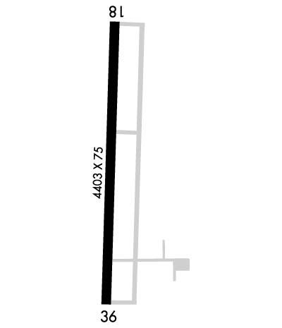
  • Runway Identifications
    Runway Identification: 18/36
    Length: 4403 ft
    Width: 75 ft
    Surface: ASPHALT-GOOD CONDITION
    Edge lights: Medium Intensity

    Treatment: NONE
    Weight: PCN 9 /F/D/X/T

     Runway: 18   Runway: 36
    Mag heading: 176°Mag heading: 356°
    Rwy Slope: .34% UpRwy Slope: -.34% Down
    Approach: Approach:
    Pattern: Left TrafficPattern: Left Traffic
    Markings: NONPRECISION INSTRUMENTMarkings: NONPRECISION INSTRUMENT
    Marking Condition: FAIRMarking Condition: FAIR
    Arresting Dev: Arresting Dev:
    Lat & Long: N3748.3  W09446.2Lat. & Long.: N3747.5  W09446.2
    Elev: 903.2 ft. MSLElev: 918.0 ft. MSL
    TCH: 33 ft. AGLTCH: 44 ft. AGL
    Visual Glide Path: 3.00 degreesVisual Glide Path: 3.00 degrees
    Displaced Threshold: NoDisplaced Threshold: No
    Touchdown Zone: YESTouchdown Zone: YES
    Touchdown Elev.: 914.3 feetTouchdown Elev.: 918.0 feet
    Visual Glide Slope: 4-BOX VASI ON LEFT SIDE OF RUNWAYVisual Glide Slope: 2-Light PAPI on LEFT side of Runway
    RVR Equipment: RVR Equipment:
    RVV Equipment: NORVV Equipment: NO
    Approach Lights: Approach Lights:
    REIL: YESREIL: YES
    Centerline Lights: NOCenterline Lights: NO
    Touchdown lights: NOTouchdown lights: NO
    Runway Category: Runway with a Non-precision Approach having visibility minimums greater than 3/4 mileRunway Category: Runway with a Non-precision Approach having visibility minimums greater than 3/4 mile
    Declared Distances: Declared Distances:
    Obstructions: TREEObstructions: TREE
    Marked: NOT Marked/LightedMarked: NOT Marked/Lighted
    Clearance slope: 13:1Clearance slope: 21:1
    Obstruction height: 9 feet AGLObstruction height: 55 feet AGL
    Dist. from runway: 321 feetDist. from runway: 1403 feet
    Centerline offset: Centerline offset: 220 feet right of centerline
    Comments: Comments:
    C:2/P: