Click here for more info on on SMS!

KFRR

FRONT ROYAL-WARREN COUNTY
FRONT ROYAL
VA
Time Zone: Eastern
Lat: N 3855.1
Long: W 07815.2
Elev: 704
Var: +10
Longest Runway: 3008
AWOS: 121.85
CTAF: 123.0

FBO & Flight Services info for KFRR

FBOs: Update your Fuel Prices
Providing high quality fuel and services to you and your customers from Phillips 66 Aviation.
Ph: 540-635-3570
-
Freq: 123.0WebsiteE-Mail
Service
Jet
100LL
SAF
MoGas
Fuel Avail: AV GAS 24/7 self serve
Full        Caution: Fuel prices have not been updated in 33 days.
Last Update: 03/17/2024 11:16

Self  4.99    
Misc. Info: Address: 229 STOCKS AIRPORT RD,   FRONT ROYAL, VA 22630

AWOSPh: 540-635-5377
-
Freq: 121.85  
If you are an FBO, call 1-203-262-1700 to update your info or email: FltPlan.Advertising@garmin.com
Advertise your FBO on FltPlan.com

Runway & Approach Info for KFRR
Rwy
Length
Land Dist**
Approach*
  Rwy
Length
Land Dist**
Approach*
10
3008x75  3008'          
 
  
28
  3008x75  3008'          
 
 * only ILS, LOC, LDA, and SDF approaches to a specific runway are shown
** For any Declared Landing Distance Available, please see A/FD or Approach plates
Runway Weight Capability (lbs.) Help
Runway IDSingle WheelDouble WheelDouble Tandem WheelDual Double Wheel
10/2812,500N/AN/AN/A
These numbers are Advisory and are not limits.   The Airport Manager should have more accurate Weight Limits
Approach Charts
Approaches    
Current Weather/Notams
Customs Information Send updates to Support@FltPlan.com
Customs Not Available
Database effective 04/18/2024
Airport Diagram of KFRR
Airport Diagram might not be current.

Facility Name: FRONT ROYAL-WARREN COUNTY
City Name: FRONT ROYAL
County: WARREN
State abbrev: VA
State Name: VIRGINIA
   
Ownership: PUBLICLY OWNED
Use: OPEN TO THE PUBLIC
Owner's Name: COUNTY OF WARREN
Address: 220 NORTH COMMERCE AVENUE, STE 100
 FRONT ROYAL, VA 22630
Owner's Phone: 540-636-4600
  
Manager's Name: MIKE BERRY
Address: 229 STOKES AIRPORT RD
 FRONT ROYAL, VA 22630
Phone: 540-635-3570
   
FAA Region: EASTERN
FAA Field Office: DCA


Sunrise / Sunset times for FRONT ROYAL-WARREN COUNTY

DateSunriseSunset
04/18/24 Thursday6:3119:54
04/19/24 Friday6:3019:55
04/20/24 Saturday6:2819:56
04/21/24 Sunday6:2719:57
04/22/24 Monday6:2619:58
04/23/24 Tuesday6:2419:59
04/24/24 Wednesday6:2320:00
04/25/24 Thursday6:2220:01
04/26/24 Friday6:2020:02
04/27/24 Saturday6:1920:02
04/28/24 Sunday6:1820:03
04/29/24 Monday6:1720:04
04/30/24 Tuesday6:1520:05
05/01/24 Wednesday6:1420:06

Airport Facilities

Airport Attendance ScheduleMAY-SEP 7 Days A Week 0800-1700, OCT-APR 7 Days A Week 0900-1600
Airport Status OPERATIONAL (This Status can change at any time - please check NOTAMS)
Airport Lighting ScheduleACTVT MIRL RWY 10/28 - CTAF.
Airport Storage AvailableTie Downs, Hanger
Extra Services AvailableCharter, Glider, Flight Instruction, Parachute Jumping, Aircraft Rental, Annual Surveying
Wind IndicatorYES - (lighted)
Control TowerNO
CTAF Frequency123.000
Unicom Frequency123.000
Rotating Beacon ColorWG
Segmented CircleNO
Landing FeeNO

Airport Inspection Data

Airport InspectedSTATE - performed by STATE AERONAUTICAL PERSONNEL
Inspection Date05/12/2021

Airport Services

Type of Fuel AvailableGrade 100LL
Airframe Repair ServiceMINOR
Power Plant Repair ServiceMINOR

Geographic Data

LatitudeN3855.1
LongitudeW07815.2 (ESTIMATED)
Arpt Elevation703ft (SURVEYED)
Magnetic Variation10W
3 miles Wof FRONT ROYAL
Traffic Pattern Altitude
Sectional ChartWASHINGTON

Aircraft Data

Operations (Reported)YearlyAvg. Daily
General Aviation Transient 763221
General Aviation Local 763221
Air Taxi 6122
Commerical 00
Commuter 00
Military 4581
Aircraft based on Field
General Aviation Singles 24
General Aviation Multi 0
Jet Aircraft 0
General Aviation Helicopters 3
Military Aircraft 0
Gliders 20
Ultralights 2

FAA Services

FSS on field NO
FSS tie-in LEESBURG
FSS Phone 1-800-WX-BRIEF
Who issues Notams DCA
Notam D service at airport YES
ARTCC Name WASHINGTON

Federal Status

Airport Certification
Aircraft Rescue & Firefighting IndexNone
Airport of EntryNo
Custom Landing RightsNo
Joint Civil/MilitaryNo
Military Landing rightsNo

Federal Agreements

NATIONAL PLAN OF INTEGRATED AIRPORT SYSTEMS (NPIAS)
GRANT AGREEMENTS UNDER FAAP/ADAP/AIP
ASSURANCES PURSUANT TO TITLE VI, CIVIL RIGHTS ACT OF 1964

Remarks

GLIDER OPNS ON & INVOF ARPT.
NOISE ABATEMENT PROCS IN EFCT, CTC ARPT MGR FOR DTLS AT 540-635-3570.
DEER & GEESE ON & INVOF ARPT.
FOR CD CTC POTOMAC APCH AT 866-709-4993.
Airport Communications & Frequencies:
CTAF Frequency:
123.000
Unicom Frequency:
123.000
POTOMAC Primary Approach Frequencies:  
120.45
POTOMAC Primary Departure Frequencies:  
120.45
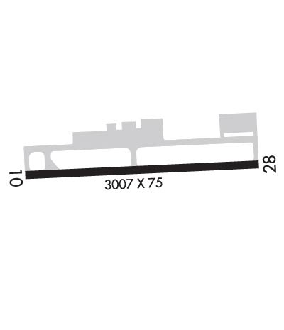
Runway Identifications
Runway Identification: 10/28
Length: 3008 ft
Width: 75 ft
Surface: ASPHALT-GOOD CONDITION
Edge lights: Medium Intensity

Treatment: NONE

 Runway: 10   Runway: 28
Mag heading: 97°Mag heading: 277°
Rwy Slope: .35% UpRwy Slope: -.35% Down
Approach: Approach:
Pattern: Left Traffic; RY 10 RIGHT TFC FOR GYROCOPTERS, ULTRALIGHTS & GLIDERS.Pattern: Left Traffic; RY 28 RIGHT TFC FOR GYROCOPTERS, ULTRALIGHTS & GLIDERS.
Markings: BASICMarkings: NONPRECISION INSTRUMENT
Marking Condition: FAIRMarking Condition: FAIR
Arresting Dev: Arresting Dev:
Lat & Long: N3855.0  W07815.5Lat. & Long.: N3855.1  W07814.9
Elev: 693.0 ft. MSLElev: 703.5 ft. MSL
TCH: 16 ft. AGLTCH: 16 ft. AGL
Visual Glide Path: 3.00 degreesVisual Glide Path: 3.00 degrees
Displaced Threshold: NoDisplaced Threshold: No
Touchdown Zone: YESTouchdown Zone: YES
Touchdown Elev.: 703.6 feetTouchdown Elev.: 703.6 feet
Visual Glide Slope: SYSTEM OF PANELS ON RIGHT SIDE OF RUNWAY (May NOT Be Lighted)Visual Glide Slope: SYSTEM OF PANELS ON LEFT SIDE OF RUNWAY (May NOT Be Lighted)
RVR Equipment: RVR Equipment:
RVV Equipment: NORVV Equipment: NO
Approach Lights: Approach Lights:
REIL: NOREIL: NO
Centerline Lights: NOCenterline Lights: NO
Touchdown lights: NOTouchdown lights: NO
Runway Category: Runway with a Visual ApproachRunway Category: Runway with a Visual Approach
Declared Distances: Declared Distances:
Obstructions: ROADObstructions: POLE
Marked: NOT Marked/LightedMarked: NOT Marked/Lighted
Clearance slope: 6:1Clearance slope: 28:1
Obstruction height: 24 feet AGLObstruction height: 42 feet AGL
Dist. from runway: 350 feetDist. from runway: 1382 feet
Centerline offset: 131 left of centerlineCenterline offset: 63 feet right of centerline
Comments: Comments:
C:1/P: