
| ||||||
| ||||||
|
| Rwy | Rwy | |||||||
| 4503x100 | 4503' | 4503x100 | 4503' | |||||
| Runway ID | Single Wheel | Double Wheel | Double Tandem Wheel | Dual Double Wheel |
| 04/22 | N/A | N/A | N/A | N/A |
| H1 | N/A | N/A | N/A | N/A |
| These numbers are Advisory and are not limits. The Airport Manager should have more accurate Weight Limits | ||||
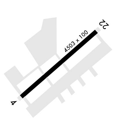 Airport Diagram might not be current. | |
| Facility Name: | MARSHALL AAF |
| City Name: | FORT RILEY (JUNCTION CITY) |
| County: | RILEY |
| State abbrev: | KS |
| State Name: | KANSAS |
| Ownership: | ARMY OWNED |
| Use: | PRIVATE |
| Owner's Name: | US ARMY AERONAUTICAL SVCS AGENCY |
| Address: | |
| FT BELVOIR, VA 22060 | |
| Owner's Phone: | |
| Manager's Name: | CDR. |
| Address: | ATTN: AF2N-GT-AOD (MR. MILLARD) |
| FORT RILEY, KS | |
| Phone: | 785-239-8588 |
| FAA Region: | CENTRAL |
| FAA Field Office: | NONE |
| Date | Sunrise | Sunset |
|---|---|---|
| 04/24/24 Wednesday | 6:37 | 20:14 |
| 04/25/24 Thursday | 6:35 | 20:15 |
| 04/26/24 Friday | 6:34 | 20:16 |
| 04/27/24 Saturday | 6:33 | 20:17 |
| 04/28/24 Sunday | 6:32 | 20:18 |
| 04/29/24 Monday | 6:30 | 20:19 |
| 04/30/24 Tuesday | 6:29 | 20:20 |
| 05/01/24 Wednesday | 6:28 | 20:21 |
| 05/02/24 Thursday | 6:27 | 20:22 |
| 05/03/24 Friday | 6:26 | 20:23 |
| 05/04/24 Saturday | 6:24 | 20:24 |
| 05/05/24 Sunday | 6:23 | 20:25 |
| 05/06/24 Monday | 6:22 | 20:26 |
| 05/07/24 Tuesday | 6:21 | 20:26 |
| Airport Attendance Schedule | ALL; OPR 1300Z++ MON - 0500Z++SAT, EXC HOL. |
| Airport Status | OPERATIONAL (This Status can change at any time - please check NOTAMS) |
| Airport Lighting Schedule | ACTVT ODALS RWY 04; HIRL RWY 04/22 - CTAF. |
| Airport Storage Available | NONE |
| Extra Services Available | NONE |
| Wind Indicator | YES - (lighted) |
| Control Tower | YES |
| CTAF Frequency | 126.200; UHF CTAF- 248.65. |
| Unicom Frequency | |
| Rotating Beacon Color | SWG |
| Segmented Circle | NO |
| Landing Fee |
| Airport Inspected | No Inspection Data Available performed by the OWNER |
| Inspection Date | Unknown |
| Type of Fuel Available | None |
| Airframe Repair Service | None |
| Power Plant Repair Service | None |
| Latitude | N3903.2 |
| Longitude | W09645.9 (ESTIMATED) |
| Arpt Elevation | 1066ft (SURVEYED) |
| Magnetic Variation | 06E |
| 3 miles NE | of FORT RILEY (JUNCTION CITY) |
| Traffic Pattern Altitude | 1035 |
| Sectional Chart | KANSAS CITY |
| Operations (Reported) | Yearly | Avg. Daily |
|---|---|---|
| General Aviation Transient | 0 | 0 |
| General Aviation Local | 0 | 0 |
| Air Taxi | 0 | 0 |
| Commerical | 0 | 0 |
| Commuter | 0 | 0 |
| Military | 0 | 0 |
| Aircraft based on Field | |
|---|---|
| General Aviation Singles | 0 |
| General Aviation Multi | 0 |
| Jet Aircraft | 0 |
| General Aviation Helicopters | 0 |
| Military Aircraft | 0 |
| Gliders | 0 |
| Ultralights | 0 |
| FSS on field | NO |
| FSS tie-in | WICHITA |
| FSS Phone | 1-800-WX-BRIEF |
| Who issues Notams | FRI |
| Notam D service at airport | YES |
| ARTCC Name | KANSAS CITY |
| Airport Certification | |
| Aircraft Rescue & Firefighting Index | None |
| Airport of Entry | No |
| Custom Landing Rights | No |
| Joint Civil/Military | No |
| Military Landing rights | No |
| MILITARY USE: R3602 WX 121.025. |
| TFC PAT: LEFT AND RGT. R/W 1800 FT' F/W 2600 FT. F/W RSTD TO S TFC PAT ONLY. |
| MISC: NO HGR TRAN ACFT. BASE OPS FAX DSN 856-2745 C785-239-2745. |
| WX DSN 856-6562, C785-239-6562. FULL SVC 0600++ MON-0600Z++ SAT EXC HOL. OPR HR MAY VARY WITH LCL FLYING SKED. FULL OBSVN AUTO EQMNT IN USE, AUGMENTED DURING OPR HR. REMOTE BRIEF SVC AVBL 26 OWS, BARKSDALE AFB DSN 331-2633, C318-529-2633, TOLL FREE 1-866-223-9328. AFLD WX IS MNT BY AN/FMQ-19. |
| R/W ACFT OPR WITH MIN LGT SS-SR. MIGRATORY BIRDS VCNTY OF AFLD. |
| FULL SVC OPR 0600Z++ MON- 0600Z++SAT EXC HOL. OPR HR MAY VARY WITH LCL FLYING SKED. |
| FULL OBSN; AUTO EQPT IN USE, AUGMENTED DUR OPR HR. REMOTE BRIEF SVC AVBL 26 OWS, BARKSDALE AFB DSN 331-2633, C318-529-2633, TOLL FREE 1-866-223-9328. |
| CAUTION: WHEN CLASS D EFF UAS OPR SFC TO 2000 FT MSL. FBPAR AND REFLECTORS 280 FT FR RWY CNTRLN. |
| COMMUNICATIONS: PMSV METRO-C785-239-6562. |
| OPR AFLD OPS 1300-0700Z++ MON-FRI; 1300-2200Z++ FRI EXC HOL. |
| UHF CTAF FREQ IS 248.65. |
| RSTD: 24 HR PPR FOR ALL ACFT. CTC BASE OPS DSN 856-2530, C785-239-2530. |
| RWY H1 H1 - HOSPITAL SE CORNER. |
Airport Communications & Frequencies:
| |||||||||||||||||||||||||||
| Runway: 04 | Runway: 22 | ||
| Mag heading: | 44° | Mag heading: | 224° |
| Rwy Slope: | -.06% Down | Rwy Slope: | .06% Up |
| Approach: | Approach: | ||
| Pattern: | Right Traffic | Pattern: | Left Traffic |
| Markings: | PRECISION INSTRUMENT | Markings: | PRECISION INSTRUMENT |
| Marking Condition: | GOOD | Marking Condition: | GOOD |
| Arresting Dev: | Arresting Dev: | ||
| Lat & Long: | N3902.9 W09646.2 | Lat. & Long.: | N3903.4 W09645.5 |
| Elev: | 1065.3 ft. MSL | Elev: | 1062.8 ft. MSL |
| TCH: | TCH: | ||
| Visual Glide Path: | Visual Glide Path: | ||
| Displaced Threshold: | No | Displaced Threshold: | No |
| Touchdown Zone: | YES | Touchdown Zone: | YES |
| Touchdown Elev.: | 1065.3 feet | Touchdown Elev.: | 1064.0 feet |
| Visual Glide Slope: | Visual Glide Slope: | ||
| RVR Equipment: | RVR Equipment: | ||
| RVV Equipment: | NO | RVV Equipment: | NO |
| Approach Lights: | ODALS - omnidirectional approach lighting system | Approach Lights: | |
| REIL: | NO | REIL: | NO |
| Centerline Lights: | NO | Centerline Lights: | NO |
| Touchdown lights: | NO | Touchdown lights: | NO |
| Runway Category: | Runway Category: | ||
| Declared Distances: | Declared Distances: |
