Current Weather/Notams (Metars, TAFs, Notams, NWS Forecast, PIREPS, and nearby weather)
Customs Information Send updates to Support@FltPlan.com
Customs Not Available
Database effective 05/16/2024
Airport Diagram might not be current.
|
| Facility Name: | FRENCH LICK MUNI |
| City Name: | FRENCH LICK |
| County: | ORANGE |
| State abbrev: | IN |
| State Name: | INDIANA |
| | |
| Ownership: | PUBLICLY OWNED |
| Use: | OPEN TO THE PUBLIC |
| Owner's Name: | FRENCH LICK BOAC |
| Address: | 9764 W. C. RD. 375 S. |
| | FRENCH LICK, IN 47432 |
| Owner's Phone: | 812-936-2222 |
| | |
| Manager's Name: | MATTHEW CARSON |
| Address: | 9764 W. C. RD. 375 S. |
| | FRENCH LICK, IN 47432 |
| Phone: | 812-936-2222 |
| | |
| FAA Region: | GREAT LAKES |
| FAA Field Office: | CHI |
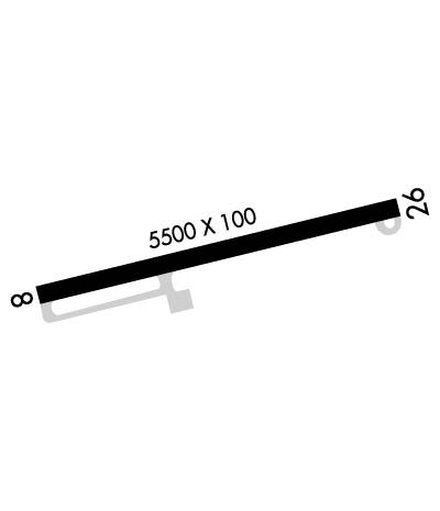
Runway Identifications
Runway Identification: 08/26Length: 5500 ft
Width: 100 ft
Surface: ASPHALT-GOOD CONDITION
Edge lights: Medium IntensityTreatment: GROOVED
| | Runway: 08 | | Runway: 26 |
| Mag heading: | 80° | Mag heading: | 260° |
| Rwy Slope: | -.12% Down | Rwy Slope: | .12% Up |
| Approach: | | Approach: | SDF |
| Pattern: | Left Traffic | Pattern: | Left Traffic |
| Markings: | NONPRECISION INSTRUMENT | Markings: | NONPRECISION INSTRUMENT |
| Marking Condition: | FAIR | Marking Condition: | FAIR |
| Arresting Dev: | | Arresting Dev: | |
| Lat & Long: | N3830.3 W08638.8 | Lat. & Long.: | N3830.5 W08637.7 |
| Elev: | 790.3 ft. MSL | Elev: | 783.6 ft. MSL |
| TCH: | 42 ft. AGL | TCH: | 44 ft. AGL |
| Visual Glide Path: | 3.00 degrees | Visual Glide Path: | 3.00 degrees |
| Displaced Threshold: | No | Displaced Threshold: | No |
| Touchdown Zone: | YES | Touchdown Zone: | YES |
| Touchdown Elev.: | 792.2 feet | Touchdown Elev.: | 792.2 feet |
| Visual Glide Slope: | 4-Light PAPI on LEFT side of Runway | Visual Glide Slope: | 4-Light PAPI on LEFT side of Runway |
| RVR Equipment: | | RVR Equipment: | |
| RVV Equipment: | NO | RVV Equipment: | NO |
| Approach Lights: | | Approach Lights: | |
| REIL: | YES | REIL: | YES |
| Centerline Lights: | NO | Centerline Lights: | NO |
| Touchdown lights: | NO | Touchdown lights: | NO |
| Runway Category: | Runway with a Non-precision Approach having visibility minimums greater than 3/4 mile | Runway Category: | Runway with a Non-precision Approach having visibility minimums greater than 3/4 mile |
| Declared Distances: | TORA:5500' TODA:5500' ASDA:5309' LDA:5309' | Declared Distances: | TORA:5500' TODA:5500' ASDA:5298' LDA:5298' |
| Obstructions: | TREES | Obstructions: | TREES |
| Marked: | NOT Marked/Lighted | Marked: | NOT Marked/Lighted |
| Clearance slope: | 20:1 | Clearance slope: | 32:1 |
| Obstruction height: | 25 feet AGL | Obstruction height: | 34 feet AGL |
| Dist. from runway: | 700 feet | Dist. from runway: | 1320 feet |
| Centerline offset: | B | Centerline offset: | B |
| Comments: | 8 FT BRUSH 110 FT FROM RWY END. | Comments: | 8 FT BRUSH 40 FT FROM RWY END 240 FT L OF CNTRLN. |

