Click here for more info on on SMS!

KFPR

TREASURE COAST INTL
FORT PIERCE
FL
Time Zone: Eastern
Lat: N 2729.8
Long: W 08022.4
Elev: 23
Var: +07
Longest Runway: 6492
Dept. ATIS: 134.82
Arr. ATIS: 134.82
Ground: 119.55
Tower: 128.2

FBO & Flight Services info for KFPR

FBOs: Update your Fuel Prices
AVOID THE CONGESTED INTERNATIONAL TRAFFIC IN SOUTH FLORIDA! No landing fees, low prices, incredibly fast service. We have it all. US Customs steps away from lobby. Home of the Airport Tiki Restaurant. Why go anywhere else? Colt, UVair, JFI, Mariah, Mercury, Everest, World.
Ph: 772-489-2285 Fax: 772-468-0252 Freq: 122.95WebsiteE-Mail
                     
Service
Jet
100LL
SAF
MoGas
Fuel Avail: PRIST PREMIXED. Hrs 7A-9P, 7 Days, self-service 24/7
Full6.106.15    Last Update: 04/14/2024 10:59

Prices may change weekly, call for current price
Self  5.65    
Misc. Info: CONTRACT CARDS ACCEPTEDAddress: 2982 CURTIS KING BLVD.   FORT PIERCE, FL 34946

AMRI MROPh: 772-242-1949 Fax: 954-333-3575
-
Service
Jet
100LL
SAF
MoGas
Fuel Avail: ~~NO FUEL AVAILABLE
Full        Last Update: 04/19/2024 00:01:44  
Self        
ASOSPh: 772-489-4281
-
-
 
If you are an FBO, call 1-203-262-1700 to update your info or email: FltPlan.Advertising@garmin.com
Advertise your FBO on FltPlan.com
FBOs at nearby airports who want your business:
KVRB


  click here  
Welcome to Corporate Air Inc., a full service FBO in Vero Beach
- Luxurious state of the art FBO & ramp space to handle up to a Boeing Business Jet
- 70,000 sq ft of hangar space
- Maintenance, GPU, car rental, & NATA Safety First trained linemen
- (6 a.m. - 9 p.m) after hours avail
- CAA Preferred
- Jet A $6.09, 100LL $6.31 & Self-Serve $5.46
Ph: 1-772-562-1199WebsiteE-MailFax: 1-000-000-0000Freq: 122.77

Runway & Approach Info for KFPR
Rwy
Length
Land Dist**
Approach*
  Rwy
Length
Land Dist**
Approach*
10L
4000x75  4000'          
 
  
28R
  4000x75  4000'          
 
10R
6492x150  6492'          
ILS/DME
 110.55 - 097°  
  
28L
  6492x150  6492'          
 
14
4755x100  4755'          
 
  
32
  4755x100  4755'          
 
 * only ILS, LOC, LDA, and SDF approaches to a specific runway are shown
** For any Declared Landing Distance Available, please see A/FD or Approach plates
Runway Weight Capability (lbs.) Help
Runway IDSingle WheelDouble WheelDouble Tandem WheelDual Double Wheel
10L/28R15,000N/AN/AN/A
10R/28L50,000110,000230,000N/A
14/3215,000N/AN/AN/A
These numbers are Advisory and are not limits.   The Airport Manager should have more accurate Weight Limits
Approach Charts
Approaches    
Current Weather/Notams
Customs Information Send updates to Support@FltPlan.com
Phone 772-461-1733
Fax 772-466-1126

Comments Sun-Sat 1000-1800 1 hr advance notice required
Database effective 04/18/2024
Airport Diagram of KFPR
Airport Diagram might not be current.

Facility Name: TREASURE COAST INTL
City Name: FORT PIERCE
County: ST LUCIE
State abbrev: FL
State Name: FLORIDA
   
Ownership: PUBLICLY OWNED
Use: OPEN TO THE PUBLIC
Owner's Name: ST. LUCIE COUNTY
Address: 2300 VIRGINIA AVE
 FT PIERCE, FL 34982-5652
Owner's Phone: 772-462-1732
  
Manager's Name: CAMERON HOWARD
Address: 3000 CURTIS KING BOULEVARD
 FT PIERCE, FL 34946
Phone: 772-462-1727
   
FAA Region: SOUTHERN
FAA Field Office: ORL


Sunrise / Sunset times for TREASURE COAST INTL

DateSunriseSunset
04/18/24 Thursday6:5319:48
04/19/24 Friday6:5219:49
04/20/24 Saturday6:5119:49
04/21/24 Sunday6:5019:50
04/22/24 Monday6:5019:51
04/23/24 Tuesday6:4919:51
04/24/24 Wednesday6:4819:52
04/25/24 Thursday6:4719:52
04/26/24 Friday6:4619:53
04/27/24 Saturday6:4519:53
04/28/24 Sunday6:4419:54
04/29/24 Monday6:4319:55
04/30/24 Tuesday6:4319:55
05/01/24 Wednesday6:4219:56

Airport Facilities

Airport Attendance Schedule7 Days A Week 0700-2100
Airport Status OPERATIONAL (This Status can change at any time - please check NOTAMS)
Airport Lighting ScheduleACTVT REIL RWY 10R & 28L; MIRL RWY 10L/28R, 10R/28L & 14/32 - CTAF.
Airport Storage AvailableTie Downs, Hanger
Extra Services AvailableAir Ambulance, Avionics, Charter, Flight Instruction, Aircraft Rental, Aircraft Sales
Wind IndicatorYES - (lighted)
Control TowerYES
CTAF Frequency128.200
Unicom Frequency
Rotating Beacon ColorWG
Segmented CircleY-L
Landing FeeNO

Airport Inspection Data

Airport InspectedSTATE - performed by STATE AERONAUTICAL PERSONNEL
Inspection Date01/09/2024

Airport Services

Type of Fuel AvailableGrade 100LL, JET A (freeze point -40C); -10100LL SELF SERVE
Airframe Repair ServiceMAJOR
Power Plant Repair ServiceMAJOR

Geographic Data

LatitudeN2729.8
LongitudeW08022.4 (ESTIMATED)
Arpt Elevation23ft (SURVEYED)
Magnetic Variation07W
3 miles NWof FORT PIERCE
Traffic Pattern Altitude
Sectional ChartMIAMI

Aircraft Data

Operations (Reported)YearlyAvg. Daily
General Aviation Transient 92120252
General Aviation Local 103880285
Air Taxi 00
Commerical 00
Commuter 00
Military 00
Aircraft based on Field
General Aviation Singles 99
General Aviation Multi 26
Jet Aircraft 4
General Aviation Helicopters 8
Military Aircraft 0
Gliders 1
Ultralights 0

FAA Services

FSS on field NO
FSS tie-in MIAMI
FSS Phone 1-800-WX-BRIEF
Who issues Notams FPR
Notam D service at airport YES
ARTCC Name MIAMI

Federal Status

Airport Certification
Aircraft Rescue & Firefighting IndexLGTD ARFF COM ANT 125 FT AGL (149 FT AMSL) LCTD 793 FT SSE OF RWY 27 THLD.
Airport of EntryNo
Custom Landing RightsYES
Joint Civil/MilitaryNo
Military Landing rightsYES

Federal Agreements

NATIONAL PLAN OF INTEGRATED AIRPORT SYSTEMS (NPIAS)
GRANT AGREEMENTS UNDER FAAP/ADAP/AIP
ASSURANCES PURSUANT TO TITLE VI, CIVIL RIGHTS ACT OF 1964
AGREEMENT UNDER DLAND OR DCLA HAS EXPIRED.

Remarks

THIS AIRPORT HAS BEEN SURVEYED BY THE NATIONAL GEODETIC SURVEY.
8 FT FENCE 400 FT FM CNTRLN ON NORTH SIDE OF RWY 10R/28L AND EAST OF RWY 14/32.
VOLUNTARY NOISE ABATEMENT PROCS IN EFCT, CTC ARPT MGMT AT 772-462-1732.
LGTD ARFF COM ANT 125 FT AGL (149 FT AMSL) LCTD 793 FT SSE OF RWY 27 THLD.
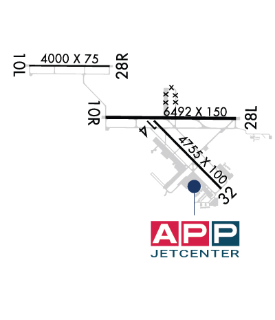
RWY 10L/28R VFR TRNG RWY.
HIGH TENSION PLINES 1/4 SM 'W' AER 10L UNMKD & UNLIGHTED.
DRAINAGE CHANNEL 80 FT WIDE, 10 FT DEEP, 600 FT FM AER 10L.
DRAINAGE CHANNEL 80 FT WIDE, 10 FT DEEP 530 FT AER 28R. 2 FT DRAINAGE DITCH 361 FT FR RY 10R THLD 259 FT RIGHT.
2 FT DRAINAGE DITCH 797 FT FM THR RWY 28L 349 FT LEFT.
2 FT DRAINAGE DITCH 367 FT 'W' OF TWY 'A1' BTWN TWY 'A' & RWY 10L/28R.
FOR CD, IF UNA VIA GCO, CTC PALM BEACH APCH AT 561-684-9047 OR 561-275-1430.
GCO AVBL ON FREQ 119.55 PALM BEACH CD.
EXTENSIVE FLIGHT TRAINING ON AND WITHIN 20 MILES OF ARPT BLO 6000 FT. VFR TRAINING ACFT OUTSIDE OF CLASS D AIRSPACE TRANSMIT INTENDED ACTIVITY ON 123.3.
NUMEROUS FLOCKS OF BIRDS & WILDLIFE ON AND INVOF ARPT.
TWY C1 RESTRICTED TO ACFT WITH A WING SPAN OF 105 FT OR LESS.
RWY 10R/ 28L25' PAVED SHOULDERS.
RWY 14/3 2 50' PAVED SHOULDERS.
Airport Communications & Frequencies:
ATIS Frequencies:   Hours(local) of Operation: CONTINUOUS
134.825
FT PIERCE Tower Frequencies:   Hours(local) of operation: 0700-2100   
128.2
FT PIERCE Ground Frequencies:
119.55
CTAF Frequency:
128.200
MIAMI ARTCC Primary Approach Frequencies:  
132.8 SOUTH
MIAMI ARTCC Primary Departure Frequencies:  
132.8 SOUTH
Runway Identifications
Runway Identification: 10L/28R
Length: 4000 ft
Width: 75 ft
Surface: ASPHALT-GOOD CONDITION
Edge lights: Medium Intensity

Treatment: NONE
Weight: PCN 10 /F/A/Y/T

 Runway: 10L   Runway: 28R
Mag heading: 97°Mag heading: 277°
Rwy Slope: .00% UpRwy Slope: .00% Down
Approach: Approach:
Pattern: Left TrafficPattern: Right Traffic
Markings: BASICMarkings: BASIC
Marking Condition: GOODMarking Condition: GOOD
Arresting Dev: Arresting Dev:
Lat & Long: N2730.3  W08023.5Lat. & Long.: N2730.3  W08022.7
Elev: 22.9 ft. MSLElev: 23.0 ft. MSL
TCH: TCH:
Visual Glide Path: Visual Glide Path:
Displaced Threshold: NoDisplaced Threshold: No
Touchdown Zone: YESTouchdown Zone: YES
Touchdown Elev.: 23.0 feetTouchdown Elev.: 23.0 feet
Visual Glide Slope: Visual Glide Slope:
RVR Equipment: RVR Equipment:
RVV Equipment: NORVV Equipment: NO
Approach Lights: Approach Lights:
REIL: NOREIL: NO
Centerline Lights: NOCenterline Lights: NO
Touchdown lights: NOTouchdown lights: NO
Runway Category: Runway with a Visual ApproachRunway Category: Runway with a Visual Approach
Declared Distances: Declared Distances:
Obstructions: PLINEObstructions: TREES
Marked: NOT Marked/LightedMarked: NOT Marked/Lighted
Clearance slope: 20:1Clearance slope: 16:1; RWY 28R APCH SLP 21:1 TO AER.
Obstruction height: 78 feet AGLObstruction height: 40 feet AGL
Dist. from runway: 1765 feetDist. from runway: 840 feet
Centerline offset: Centerline offset: 105 feet left of centerline
Comments: Comments:
Runway Identification: 10R/28L
Length: 6492 ft
Width: 150 ft
Surface: ASPHALT-FAIR CONDITION
Edge lights: Medium Intensity

Treatment: NONE
Weight: PCN 33 /F/A/X/T

 Runway: 10R   Runway: 28L
Mag heading: 97°Mag heading: 277°
Rwy Slope: -.03% DownRwy Slope: .03% Up
Approach: ILS/DMEApproach:
Pattern: Left TrafficPattern: Right Traffic
Markings: PRECISION INSTRUMENTMarkings: PRECISION INSTRUMENT
Marking Condition: GOODMarking Condition: GOOD
Arresting Dev: Arresting Dev:
Lat & Long: N2729.8  W08022.8Lat. & Long.: N2729.8  W08021.6
Elev: 23.0 ft. MSLElev: 21.1 ft. MSL
TCH: 52 ft. AGLTCH: 59 ft. AGL
Visual Glide Path: 3.00 degreesVisual Glide Path: 3.00 degrees
Displaced Threshold: NoDisplaced Threshold: No
Touchdown Zone: YESTouchdown Zone: YES
Touchdown Elev.: 23.3 feetTouchdown Elev.: 23.2 feet
Visual Glide Slope: 4-BOX VASI ON LEFT SIDE OF RUNWAYVisual Glide Slope: 4-BOX VASI ON LEFT SIDE OF RUNWAY
RVR Equipment: RVR Equipment:
RVV Equipment: NORVV Equipment: NO
Approach Lights: Approach Lights:
REIL: YESREIL: YES
Centerline Lights: NOCenterline Lights: NO
Touchdown lights: NOTouchdown lights: NO
Runway Category: Precision Instrument RunwayRunway Category: Runway with a Non-precision Approach having visibility minimums greater than 3/4 mile
Declared Distances: Declared Distances:
Obstructions: TREESObstructions: TREES
Marked: NOT Marked/LightedMarked: NOT Marked/Lighted
Clearance slope: 45:1; RWY 10R APCH SLP 50:1 TO AER.Clearance slope: 27:1; RWY 28L APCH SLP 34:1 TO AER.
Obstruction height: 26 feet AGLObstruction height: 35 feet AGL
Dist. from runway: 1380 feetDist. from runway: 1160 feet
Centerline offset: 555 left of centerlineCenterline offset: 400 feet right of centerline
Comments: Comments:
Runway Identification: 14/32
Length: 4755 ft
Width: 100 ft
Surface: ASPHALT
Edge lights: Medium Intensity

Treatment: NONE
Weight: PCN 38 /F/B/X/T

 Runway: 14   Runway: 32
Mag heading: 142°Mag heading: 322°
Rwy Slope: .01% UpRwy Slope: -.01% Down
Approach: Approach:
Pattern: Right TrafficPattern: Left Traffic
Markings: NONPRECISION INSTRUMENTMarkings: NONPRECISION INSTRUMENT
Marking Condition: GOODMarking Condition: GOOD
Arresting Dev: Arresting Dev:
Lat & Long: N2729.8  W08022.3Lat. & Long.: N2729.2  W08021.7
Elev: 22.5 ft. MSLElev: 22.9 ft. MSL
TCH: 46 ft. AGLTCH:
Visual Glide Path: 3.00 degreesVisual Glide Path:
Displaced Threshold: NoDisplaced Threshold: No
Touchdown Zone: YESTouchdown Zone: YES
Touchdown Elev.: 23.4 feetTouchdown Elev.: 23.4 feet
Visual Glide Slope: 4-Light PAPI on LEFT side of RunwayVisual Glide Slope:
RVR Equipment: RVR Equipment:
RVV Equipment: NORVV Equipment: NO
Approach Lights: Approach Lights:
REIL: NOREIL: NO
Centerline Lights: NOCenterline Lights: NO
Touchdown lights: NOTouchdown lights: NO
Runway Category: Runway with a Non-precision Approach having visibility minimums greater than 3/4 mileRunway Category: Runway with a Non-precision Approach having visibility minimums greater than 3/4 mile
Declared Distances: Declared Distances:
Obstructions: TREESObstructions: TREES
Marked: NOT Marked/LightedMarked: NOT Marked/Lighted
Clearance slope: 35:1Clearance slope: 34:1
Obstruction height: 32 feet AGLObstruction height: 43 feet AGL
Dist. from runway: 1335 feetDist. from runway: 1690 feet
Centerline offset: 260 right of centerlineCenterline offset: 220 feet left of centerline
Comments: Comments:
C:131/P: