Click here for more info on on SMS!

KFOM

FILLMORE MUNI
FILLMORE
UT
Time Zone: Mountain
Lat: N 3857.5
Long: W 11221.8
Elev: 4985
Var: -12
Longest Runway: 5040
AWOS: 133.77
CTAF: 122.8

FBO & Flight Services info for KFOM

FBOs: Update your Fuel Prices

CITY OF FILLMOREPh: 435-743-5233
-
Freq: 122.8
Service
Jet
100LL
SAF
MoGas
Full        Last Update: 04/15/2024 17:24

Self4.795.13    
 Address: 1120 W 200 S ST,   FILLMORE, UT 84631
AWOSPh: 435-743-4182
-
Freq: 133.77  
If you are an FBO, call 1-203-262-1700 to update your info or email: FltPlan.Advertising@garmin.com
Advertise your FBO on FltPlan.com

Runway & Approach Info for KFOM
Rwy
Length
Land Dist**
Approach*
  Rwy
Length
Land Dist**
Approach*
04
5040x75  5040'          
 
  
22
  5040x75  5040'          
 
 * only ILS, LOC, LDA, and SDF approaches to a specific runway are shown
** For any Declared Landing Distance Available, please see A/FD or Approach plates
Runway Weight Capability (lbs.) Help
Runway IDSingle WheelDouble WheelDouble Tandem WheelDual Double Wheel
04/2212,500N/AN/AN/A
These numbers are Advisory and are not limits.   The Airport Manager should have more accurate Weight Limits
Approach Charts
Approaches    
Current Weather/Notams
Customs Information Send updates to Support@FltPlan.com
Customs Not Available
Database effective 04/18/2024
Airport Diagram of KFOM
Airport Diagram might not be current.

Facility Name: FILLMORE MUNI
City Name: FILLMORE
County: MILLARD
State abbrev: UT
State Name: UTAH
   
Ownership: PUBLICLY OWNED
Use: OPEN TO THE PUBLIC
Owner's Name: CITY OF FILLMORE
Address: 75 WEST CENTER
 FILLMORE, UT 84631-0687
Owner's Phone: 435-743-5233
  
Manager's Name: CHRISTINE RASMUSSEN
Address: 1120 WEST 200 SOUTH
 FILLMORE, UT 84631
Phone: (435) 253-0919
   
FAA Region: NORTHWEST MOUNTAIN
FAA Field Office: DEN


Sunrise / Sunset times for FILLMORE MUNI

DateSunriseSunset
04/18/24 Thursday6:4720:10
04/19/24 Friday6:4620:11
04/20/24 Saturday6:4520:12
04/21/24 Sunday6:4320:13
04/22/24 Monday6:4220:14
04/23/24 Tuesday6:4120:15
04/24/24 Wednesday6:3920:16
04/25/24 Thursday6:3820:17
04/26/24 Friday6:3720:18
04/27/24 Saturday6:3520:19
04/28/24 Sunday6:3420:20
04/29/24 Monday6:3320:21
04/30/24 Tuesday6:3220:22
05/01/24 Wednesday6:3120:23

Airport Facilities

Airport Attendance ScheduleCONTINUOUS
Airport Status OPERATIONAL (This Status can change at any time - please check NOTAMS)
Airport Lighting ScheduleACTVT & INCR INTST REIL RWY 04 & 22; PAPI RWY 04 & 22; MIRL RWY 04/22; TWY LGTS - CTAF.
Airport Storage AvailableTie Downs, Hanger
Extra Services AvailableNONE
Wind IndicatorYES - (lighted)
Control TowerNO
CTAF Frequency122.800
Unicom Frequency122.800
Rotating Beacon ColorWG
Segmented CircleYES
Landing FeeNO

Airport Inspection Data

Airport InspectedSTATE - performed by PRIVATE CONTRACT PERSONNEL
Inspection Date09/22/2023

Airport Services

Type of Fuel AvailableGrade 100LL, JET A (freeze point -40C); -1024 HR SELF SVC.
Airframe Repair ServiceNONE
Power Plant Repair ServiceNONE

Geographic Data

LatitudeN3857.5
LongitudeW11221.8 (ESTIMATED)
Arpt Elevation4984ft (ESTIMATED)
Magnetic Variation12E
2 miles Wof FILLMORE
Traffic Pattern Altitude
Sectional ChartLAS VEGAS

Aircraft Data

Operations (Reported)YearlyAvg. Daily
General Aviation Transient 14854
General Aviation Local 1680
Air Taxi 300
Commerical 00
Commuter 00
Military 00
Aircraft based on Field
General Aviation Singles 2
General Aviation Multi 0
Jet Aircraft 0
General Aviation Helicopters 0
Military Aircraft 0
Gliders 0
Ultralights 0

FAA Services

FSS on field NO
FSS tie-in CEDAR CITY
FSS Phone 1-800-WX-BRIEF
Who issues Notams CDC
Notam D service at airport YES
ARTCC Name SALT LAKE CITY

Federal Status

Airport Certification
Aircraft Rescue & Firefighting IndexNone
Airport of EntryNo
Custom Landing RightsNo
Joint Civil/MilitaryNo
Military Landing rightsYES

Remarks

FOR CD CTC SALT LAKE ARTCC AT 801-320-2568.
SN REMOVAL SCND PRIORITY, CALL FOR FICONS.
AMGR LIVES ADJ.
Airport Communications & Frequencies:
CTAF Frequency:
122.800
Unicom Frequency:
122.800
Remarks
  • APCH/DEP CTL SVC PRVDD BY SALT LAKE ARTCC (ZLC) ON FREQS 125.575/379.275 (DELTA RCAG).
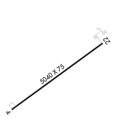
  • Runway Identifications
    Runway Identification: 04/22
    Length: 5040 ft
    Width: 75 ft
    Surface: ASPHALT-FAIR CONDITION
    Edge lights: Medium Intensity

    Treatment: NONE

     Runway: 04   Runway: 22
    Mag heading: N/AMag heading: N/A
    Rwy Slope: 1.45% UpRwy Slope: -1.45% Down
    Approach: Approach:
    Pattern: Left TrafficPattern: Left Traffic
    Markings: NONPRECISION INSTRUMENTMarkings: NONPRECISION INSTRUMENT
    Marking Condition: POOR; RWY MKGS FADED.Marking Condition: POOR; RWY MKGS FADED.
    Arresting Dev: Arresting Dev:
    Lat & Long: N3857.2  W11222.2Lat. & Long.: N3857.7  W11221.4
    Elev: 4911.5 ft. MSLElev: 4984.5 ft. MSL
    TCH: 30 ft. AGLTCH: 35 ft. AGL
    Visual Glide Path: 3.00 degreesVisual Glide Path: 3.00 degrees
    Displaced Threshold: NoDisplaced Threshold: No
    Touchdown Zone: YESTouchdown Zone: YES
    Touchdown Elev.: 4957.0 feetTouchdown Elev.: 4984.5 feet
    Visual Glide Slope: 2-Light PAPI on LEFT side of RunwayVisual Glide Slope: 2-Light PAPI on LEFT side of Runway
    RVR Equipment: RVR Equipment:
    RVV Equipment: NORVV Equipment: NO
    Approach Lights: Approach Lights:
    REIL: YESREIL: YES
    Centerline Lights: NOCenterline Lights: NO
    Touchdown lights: NOTouchdown lights: NO
    Runway Category: Runway with a Non-precision ApproachRunway Category: Runway with a Non-precision Approach
    Declared Distances: Declared Distances:
    Obstructions: Obstructions: ROAD
    Marked: Marked: NOT Marked/Lighted
    Clearance slope: 34:1Clearance slope: 15:1
    Obstruction height: Obstruction height: 27 feet AGL
    Dist. from runway: Dist. from runway: 630 feet
    Centerline offset: Centerline offset: 280 feet left of centerline
    Comments: Comments:
    C:1/P: