Click here for more info on on SMS!

KFOD

FORT DODGE RGNL
FORT DODGE
IA
Time Zone: Central
Lat: N 4233.1
Long: W 09411.5
Elev: 1156
Var: -02
Longest Runway: 6547
AWOS: 118.77
CTAF: 123.0

FBO & Flight Services info for KFOD

FBOs: Update your Fuel Prices
Providing high quality fuel and services to you and your customers, from Phillips 66 Aviation.
Ph: 515-955-3434 Fax: 515-955-4254 Freq: 123.0Website-
                               
Service
Jet
100LL
SAF
MoGas
Fuel Avail: PRIST PREMIXED
Full5.025.90    Last Update: 04/13/2024 11:42

Self4.875.75    
Misc. Info: Address: 1639 NELSON AVE STE 4,   FORT DODGE, IA 50501

AWOSPh: 515-955-5490
-
Freq: 118.77  
If you are an FBO, call 1-203-262-1700 to update your info or email: FltPlan.Advertising@garmin.com
Advertise your FBO on FltPlan.com

Runway & Approach Info for KFOD
Rwy
Length
Land Dist**
Approach*
  Rwy
Length
Land Dist**
Approach*
06
6547x150  6547'          
ILS
 109.10 - 063°  
  
24
  6547x150  6547'          
 
12
5301x100  5301'          
 
  
30
  5301x100  5301'          
 
 * only ILS, LOC, LDA, and SDF approaches to a specific runway are shown
** For any Declared Landing Distance Available, please see A/FD or Approach plates
Runway Weight Capability (lbs.) Help
Runway IDSingle WheelDouble WheelDouble Tandem WheelDual Double Wheel
06/2465,000110,000165,000N/A
12/3036,00058,000N/AN/A
These numbers are Advisory and are not limits.   The Airport Manager should have more accurate Weight Limits
Approach Charts
Approaches    
Current Weather/Notams
Customs Information Send updates to Support@FltPlan.com
Customs Not Available
Database effective 04/18/2024
Airport Diagram of KFOD
Airport Diagram might not be current.

Facility Name: FORT DODGE RGNL
City Name: FORT DODGE
County: WEBSTER
State abbrev: IA
State Name: IOWA
   
Ownership: PUBLICLY OWNED
Use: OPEN TO THE PUBLIC
Owner's Name: CITY OF FORT DODGE
Address: 819 FIRST AVE SOUTH
 FORT DODGE, IA 50501
Owner's Phone: 515-573-7144
  
Manager's Name: MS. RHONDA CHAMBERS
Address: 1639 NELSON AVE SUITE 2; EMAIL ADDRESS: RCHAMBERS@FORTDODGEIOWA.ORG (ALL LOWER CASE)
 FORT DODGE, IA 50501
Phone: 515-573-3881
   
FAA Region: CENTRAL
FAA Field Office: NONE


Sunrise / Sunset times for FORT DODGE RGNL

DateSunriseSunset
04/17/24 Wednesday6:3120:02
04/18/24 Thursday6:3020:03
04/19/24 Friday6:2820:04
04/20/24 Saturday6:2620:05
04/21/24 Sunday6:2520:06
04/22/24 Monday6:2320:08
04/23/24 Tuesday6:2220:09
04/24/24 Wednesday6:2020:10
04/25/24 Thursday6:1920:11
04/26/24 Friday6:1720:12
04/27/24 Saturday6:1620:13
04/28/24 Sunday6:1520:14
04/29/24 Monday6:1320:15
04/30/24 Tuesday6:1220:17

Airport Facilities

Airport Attendance Schedule7 Days A Week 0400-1730; FOR ATTENDANT AFT HRS CALL (515) 955-3434/332-4955.
Airport Status OPERATIONAL (This Status can change at any time - please check NOTAMS)
Airport Lighting Schedule
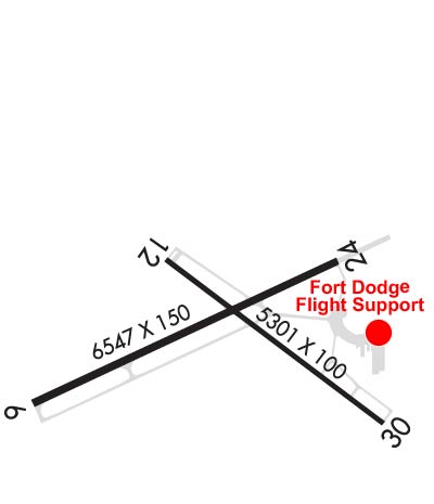
ACTVT HIRL RY 06/24; MIRL RY 12/30; REIL RYS 12, 24 & 30; MALSR RY 06 & VASI RYS 12 & 24 & PAPI RYS 06 & 30 - CTAF.
Airport Storage AvailableTie Downs, Hanger
Extra Services AvailableAir Freight, Avionics, Charter, Flight Instruction, Aircraft Rental
Wind IndicatorYES - (lighted)
Control TowerNO
CTAF Frequency123.000
Unicom Frequency123.000
Rotating Beacon ColorWG
Segmented CircleNO
Landing FeeNO

Airport Inspection Data

Airport InspectedFEDERAL - performed by FAA AIRPORTS FIELD PERSONNEL
Inspection Date05/23/2023

Airport Services

Type of Fuel AvailableGrade 100LL, JET A (freeze point -40C); -10100LL AND JET A SELF-SVC FUEL AVBL.
Airframe Repair ServiceMAJOR
Power Plant Repair ServiceMAJOR

Geographic Data

LatitudeN4233.1
LongitudeW09411.5 (ESTIMATED)
Arpt Elevation1156ft (SURVEYED)
Magnetic Variation02E
3 miles Nof FORT DODGE
Traffic Pattern Altitude843
Sectional ChartOMAHA

Aircraft Data

Operations (Reported)YearlyAvg. Daily
General Aviation Transient 500014
General Aviation Local 400011
Air Taxi 2501
Commerical 12483
Commuter 00
Military 1000
Aircraft based on Field
General Aviation Singles 19
General Aviation Multi 2
Jet Aircraft 0
General Aviation Helicopters 1
Military Aircraft 0
Gliders 0
Ultralights 0

FAA Services

FSS on field NO
FSS tie-in FORT DODGE
FSS Phone 1-800-WX-BRIEF
Who issues Notams FOD
Notam D service at airport YES
ARTCC Name MINNEAPOLIS

Federal Status

Airport CertificationAIRPORT RECEIVING SCHEDULED AIR CARRIER SERVICE FROM CARRIERS CERTIFICATED BY THE CIVIL AERONAUTICS BOARD; ARFF INDEX B PROVIDED.
Aircraft Rescue & Firefighting IndexAIRPORT HAS A CERTIFICATE UNDER CFR PART 139
Airport of EntryNo
Custom Landing RightsNo
Joint Civil/MilitaryNo
Military Landing rightsYES

Federal Agreements

NATIONAL PLAN OF INTEGRATED AIRPORT SYSTEMS (NPIAS)
GRANT AGREEMENTS UNDER FAAP/ADAP/AIP
ASSURANCES PURSUANT TO TITLE VI, CIVIL RIGHTS ACT OF 1964

Remarks

ACR OPNS INVOLVING ACFT WITH MORE THAN 9 PASSENGER SEATS ARE NOT AUTHORIZED IN EXCESS OF 15 MINS BEFORE OR AFT SCHEDULED ARR OR DEP TIMES WITHOUT PRIOR COORD WITH ARPT MANAGEMENT AND/OR ARPT MAINT & CONFIRMATION THAT ARFF SVCS ARE AVBL PRIOR TO LANDING OR TAKEOFF.
RY 06 IS CALM WIND RY.
SFC CONDS NOT MONTRD ON WKENDS AND BTWN 1600-0500 MON-FRI.
FOR CD IF UNA TO CTC ON FSS FREQ, CTC MINNEAPOLIS ARTCC AT 651-463-5588.
Airport Communications & Frequencies:
CTAF Frequency:
123.000
Unicom Frequency:
123.000
Remarks
  • APCH/DEP SVC PRVDD BY MINNEAPOLIS ARTCC ON FREQS 134.0/288.3 (FORT DODGE RCAG).
  • Runway Identifications
    Runway Identification: 06/24
    Length: 6547 ft
    Width: 150 ft
    Surface: ASPHALT
    Edge lights: High Intensity

    Treatment: GROOVED
    Weight: PCN 60 /F/B/X/T

     Runway: 06   Runway: 24
    Mag heading: 63°Mag heading: 243°
    Rwy Slope: 1.17% UpRwy Slope: -1.17% Down
    Approach: ILSApproach:
    Pattern: Left TrafficPattern: Left Traffic
    Markings: PRECISION INSTRUMENTMarkings: NONPRECISION INSTRUMENT
    Marking Condition: GOODMarking Condition: GOOD
    Arresting Dev: Arresting Dev:
    Lat & Long: N4232.9  W09412.3Lat. & Long.: N4233.3  W09411.0
    Elev: 1079.5 ft. MSLElev: 1156.3 ft. MSL
    TCH: 55 ft. AGLTCH: 41 ft. AGL
    Visual Glide Path: 3.00 degreesVisual Glide Path: 3.00 degrees
    Displaced Threshold: NoDisplaced Threshold: No
    Touchdown Zone: YESTouchdown Zone: YES
    Touchdown Elev.: 1106.5 feetTouchdown Elev.: 1156.3 feet
    Visual Glide Slope: 4-Light PAPI on LEFT side of RunwayVisual Glide Slope: 4-BOX VASI ON LEFT SIDE OF RUNWAY
    RVR Equipment: RVR Equipment:
    RVV Equipment: NORVV Equipment: NO
    Approach Lights: MALSR - 1,400 foot medium intensity approach lighting system with runway alignment indicator lightsApproach Lights:
    REIL: NOREIL: YES
    Centerline Lights: NOCenterline Lights: NO
    Touchdown lights: NOTouchdown lights: NO
    Runway Category: Precision Instrument RunwayRunway Category: Runway with a Non-precision Approach having visibility minimums greater than 3/4 mile
    Declared Distances: TORA:6547' TODA:6547' ASDA:6547' LDA:6547'Declared Distances: TORA:6547' TODA:6547' ASDA:6547' LDA:6547'
    Runway Identification: 12/30
    Length: 5301 ft
    Width: 100 ft
    Surface: ASPHALT
    Edge lights: Medium Intensity

    Treatment: GROOVED
    Weight: PCN 52 /F/B/X/T

     Runway: 12   Runway: 30
    Mag heading: 125°Mag heading: 305°
    Rwy Slope: .56% UpRwy Slope: -.56% Down
    Approach: Approach:
    Pattern: Left TrafficPattern: Left Traffic
    Markings: NONPRECISION INSTRUMENTMarkings: NONPRECISION INSTRUMENT
    Marking Condition: GOODMarking Condition: GOOD
    Arresting Dev: Arresting Dev:
    Lat & Long: N4233.3  W09411.8Lat. & Long.: N4232.8  W09410.8
    Elev: 1112.3 ft. MSLElev: 1141.8 ft. MSL
    TCH: 51 ft. AGLTCH: 39 ft. AGL
    Visual Glide Path: 3.00 degreesVisual Glide Path: 3.00 degrees
    Displaced Threshold: NoDisplaced Threshold: No
    Touchdown Zone: YESTouchdown Zone: YES
    Touchdown Elev.: 1127.6 feetTouchdown Elev.: 1141.8 feet
    Visual Glide Slope: 4-BOX VASI ON LEFT SIDE OF RUNWAYVisual Glide Slope: 4-Light PAPI on LEFT side of Runway
    RVR Equipment: RVR Equipment:
    RVV Equipment: NORVV Equipment: NO
    Approach Lights: Approach Lights:
    REIL: YESREIL: YES
    Centerline Lights: NOCenterline Lights: NO
    Touchdown lights: NOTouchdown lights: NO
    Runway Category: Runway with a Non-precision Approach having visibility minimums greater than 3/4 mileRunway Category: Runway with a Non-precision Approach having visibility minimums greater than 3/4 mile
    Declared Distances: TORA:5301' TODA:5301' ASDA:5301' LDA:5301'Declared Distances: TORA:5301' TODA:5301' ASDA:5301' LDA:5301'
    Obstructions: Obstructions: POLE
    Marked: Marked: NOT Marked/Lighted
    Clearance slope: 50:1Clearance slope: 38:1
    Obstruction height: Obstruction height: 30 feet AGL
    Dist. from runway: Dist. from runway: 1340 feet
    Centerline offset: Centerline offset: 224 feet left of centerline
    Comments: Comments:
    C:7/P: