Current Weather/Notams (Metars, TAFs, Notams, NWS Forecast, PIREPS, and nearby weather)
Customs Information Send updates to Support@FltPlan.com
Phone 989-695-2871
Fax N/A
Comments M-F 0800-1600 *3 hrs advance notice required. *Maximum passengers per flight: 10 *Call prior to 1700 on preceding weekday.
Database effective 05/16/2024
Airport Diagram might not be current.
|
| Facility Name: | BISHOP INTL |
| City Name: | FLINT |
| County: | GENESEE |
| State abbrev: | MI |
| State Name: | MICHIGAN |
| | |
| Ownership: | PUBLICLY OWNED |
| Use: | OPEN TO THE PUBLIC |
| Owner's Name: | BISHOP INTL ARPT AUTH |
| Address: | G-3425 W BRISTOL RD |
| | FLINT, MI 48507 |
| Owner's Phone: | 810-235-6560 |
| | |
| Manager's Name: | NINO SAPONE |
| Address: | G-3425 W BRISTOL RD |
| | FLINT, MI 48507 |
| Phone: | 810-235-6560 |
| | |
| FAA Region: | GREAT LAKES |
| FAA Field Office: | DET |
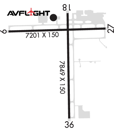
Runway Identifications
Runway Identification: 09/27Length: 7201 ft
Width: 150 ft
Surface: ASPHALT-GOOD CONDITION
Edge lights: High IntensityTreatment: GROOVED
Weight: PCN 88 /F/A/W/T
| | Runway: 09 | | Runway: 27 |
| Mag heading: | 94° | Mag heading: | 274° |
| Rwy Slope: | -.02% Down | Rwy Slope: | .02% Up |
| Approach: | ILS | Approach: | ILS |
| Pattern: | Left Traffic | Pattern: | Left Traffic |
| Markings: | PRECISION INSTRUMENT | Markings: | PRECISION INSTRUMENT |
| Marking Condition: | GOOD | Marking Condition: | GOOD |
| Arresting Dev: | | Arresting Dev: | |
| Lat & Long: | N4258.1 W08345.6 | Lat. & Long.: | N4258.2 W08344.0 |
| Elev: | 763.8 ft. MSL | Elev: | 762.5 ft. MSL |
| TCH: | 63 ft. AGL | TCH: | 56 ft. AGL |
| Visual Glide Path: | 3.00 degrees | Visual Glide Path: | 3.00 degrees |
| Displaced Threshold: | No | Displaced Threshold: | No |
| Touchdown Zone: | YES | Touchdown Zone: | YES |
| Touchdown Elev.: | 771.1 feet | Touchdown Elev.: | 770.1 feet |
| Visual Glide Slope: | 4-Light PAPI on RIGHT side of Runway | Visual Glide Slope: | 4-Light PAPI on LEFT side of Runway |
| RVR Equipment: | TOUCHDOWN | RVR Equipment: | ROLLOUT |
| RVV Equipment: | NO | RVV Equipment: | NO |
| Approach Lights: | MALSR - 1,400 foot medium intensity approach lighting system with runway alignment indicator lights | Approach Lights: | MALSR - 1,400 foot medium intensity approach lighting system with runway alignment indicator lights |
| REIL: | NO | REIL: | NO |
| Centerline Lights: | NO | Centerline Lights: | NO |
| Touchdown lights: | NO | Touchdown lights: | NO |
| Runway Category: | Precision Instrument Runway | Runway Category: | Precision Instrument Runway |
| Declared Distances: | TORA:7201' TODA:7201' ASDA:7201' LDA:7201' | Declared Distances: | TORA:7201' TODA:7201' ASDA:7201' LDA:7201' |
| Obstructions: | TREES | Obstructions: | TREES |
| Marked: | NOT Marked/Lighted | Marked: | NOT Marked/Lighted |
| Clearance slope: | 37:1 | Clearance slope: | 36:1 |
| Obstruction height: | 60 feet AGL | Obstruction height: | 76 feet AGL |
| Dist. from runway: | 2460 feet | Dist. from runway: | 2968 feet |
| Centerline offset: | 540 left of centerline | Centerline offset: | 98 feet right of centerline |
| Comments: | | Comments: | |
Runway Identification: 18/36Length: 7852 ft
Width: 150 ft
Surface: ASPHALT-GOOD CONDITION
Edge lights: High IntensityTreatment: GROOVED
Weight: PCN 88 /F/A/W/T
| | Runway: 18 | | Runway: 36 |
| Mag heading: | 185° | Mag heading: | 5° |
| Rwy Slope: | .19% Up | Rwy Slope: | -.19% Down |
| Approach: | | Approach: | |
| Pattern: | Left Traffic | Pattern: | Left Traffic |
| Markings: | NONPRECISION INSTRUMENT | Markings: | NONPRECISION INSTRUMENT |
| Marking Condition: | GOOD | Marking Condition: | GOOD |
| Arresting Dev: | | Arresting Dev: | |
| Lat & Long: | N4258.4 W08344.6 | Lat. & Long.: | N4257.1 W08344.6 |
| Elev: | 763.9 ft. MSL | Elev: | 779.0 ft. MSL |
| TCH: | 47 ft. AGL | TCH: | 55 ft. AGL |
| Visual Glide Path: | 3.00 degrees | Visual Glide Path: | 3.00 degrees |
| Displaced Threshold: | 202 feet | Displaced Threshold: | No |
| Touchdown Zone: | YES | Touchdown Zone: | YES |
| Touchdown Elev.: | 777.0 feet | Touchdown Elev.: | 782.1 feet |
| Visual Glide Slope: | 4-Light PAPI on RIGHT side of Runway; PAPI UNUSBL BYD 8 DEGS LEFT OF CNTRLN. | Visual Glide Slope: | 4-Light PAPI on LEFT side of Runway |
| RVR Equipment: | | RVR Equipment: | |
| RVV Equipment: | NO | RVV Equipment: | NO |
| Approach Lights: | | Approach Lights: | |
| REIL: | YES | REIL: | YES |
| Centerline Lights: | NO | Centerline Lights: | NO |
| Touchdown lights: | NO | Touchdown lights: | NO |
| Runway Category: | Runway with a Non-precision Approach having visibility minimums greater than 3/4 mile | Runway Category: | Runway with a Non-precision Approach having visibility minimums greater than 3/4 mile |
| Declared Distances: | TORA:7852' TODA:7852' ASDA:7852' LDA:7650' | Declared Distances: | TORA:7852' TODA:7852' ASDA:7652' LDA:7652' |
| Obstructions: | TREE | Obstructions: | TREE |
| Marked: | NOT Marked/Lighted | Marked: | NOT Marked/Lighted |
| Clearance slope: | 25:1; APCH RATIO 28:1 TO DTHR. | Clearance slope: | 25:1 |
| Obstruction height: | 79 feet AGL | Obstruction height: | 69 feet AGL |
| Dist. from runway: | 2229 feet | Dist. from runway: | 1945 feet |
| Centerline offset: | 299 left of centerline | Centerline offset: | 485 feet left of centerline |
| Comments: | | Comments: | |

