Current Weather/Notams (Metars, TAFs, Notams, NWS Forecast, PIREPS, and nearby weather)
Customs Information Send updates to Support@FltPlan.com
Customs Not Available
Database effective 04/18/2024
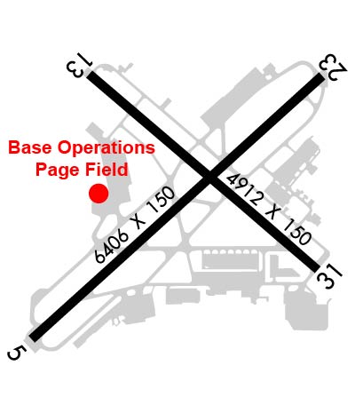
Airport Diagram might not be current. Facility Name: PAGE FLD City Name: FORT MYERS County: LEE State abbrev: FL State Name: FLORIDA Ownership: PUBLICLY OWNED Use: OPEN TO THE PUBLIC Owner's Name: LEE COUNTY PORT AUTHORITY; CTC PERSON: BENJAMIN SIEGEL 239-590-4400 Address: 11000 TERMINAL ACCESS RD SUITE 8671 FORT MYERS, FL 33913 Owner's Phone: 239-590-4800 Manager's Name: SCOTT SHEETS; AIRPORT PHYSICAL ADDRESS: 5200 CAPT. CHANNING PAGE DRIVE. Address: 5200 CAPTAIN CHANNING PAGE DRIVE FORT MYERS, FL 33907 Phone: 239-590-6601 FAA Region: SOUTHERN FAA Field Office: ORL
Runway Identifications Help
Runway Identification: 05/23 Length: 6406 ftWidth: 150 ftSurface: ASPHALTEdge lights: Medium Intensity Treatment: GROOVEDWeight: PCN 32 /F/A/X/T Runway: 05 Runway: 23 Mag heading: 51° Mag heading: 231° Rwy Slope: .07% Up Rwy Slope: -.07% Down Approach: ILS Approach: Pattern: Left Traffic Pattern: Left Traffic Markings: PRECISION INSTRUMENT Markings: PRECISION INSTRUMENT Marking Condition: GOOD Marking Condition: GOOD Arresting Dev: Arresting Dev: Lat & Long: N2634.8 W08152.3 Lat. & Long.: N2635.5 W08151.4 Elev: 12.8 ft. MSL Elev: 17.1 ft. MSL TCH: 52 ft. AGL TCH: 55 ft. AGL Visual Glide Path: 3.00 degrees Visual Glide Path: 3.00 degrees Displaced Threshold: 459 feet Displaced Threshold: 399 feet Touchdown Zone: YES Touchdown Zone: YES Touchdown Elev.: 14.6 feet Touchdown Elev.: 16.1 feet Visual Glide Slope: 4-Light PAPI on LEFT side of Runway Visual Glide Slope: 4-Light PAPI on LEFT side of Runway RVR Equipment: RVR Equipment: RVV Equipment: NO RVV Equipment: NO Approach Lights: Approach Lights: REIL: YES REIL: YES Centerline Lights: NO Centerline Lights: NO Touchdown lights: NO Touchdown lights: NO Runway Category: Precision Instrument Runway Runway Category: D Declared Distances: TORA:6406' TODA:6406' ASDA:6007' LDA:5548' Declared Distances: TORA:6406' TODA:6406' ASDA:5947' LDA:5548' Obstructions: ROAD Obstructions: RR Marked: MARKED and LIGHTED Marked: LIGHTED Clearance slope: 1:1; RWY 05 APCH SLOPE TO DSPLCD THR 34:1 DUE TO 24 FT BLDG 345 FM END OF RWY 255 FT LEFT OF CNTRLN. Clearance slope: RY 23 APCH SLOPE 25:1 TO DSPLCD THLD. Obstruction height: 15 feet AGL Obstruction height: 23 feet AGL Dist. from runway: 200 feet Dist. from runway: 180 feet Centerline offset: 125 left of centerline Centerline offset: 500 feet left of centerline Comments: RWY 05 HAS 6 FT FENCE & 15 FT ROAD 185 FT FM RWY END. Comments: RWY 23 HAS 23 FT RR 180 FT FM END OF RWY, 500 FT LEFT OF CNTRLN.
Runway Identification: 13/31 Length: 4910 ftWidth: 150 ftSurface: ASPHALTEdge lights: Medium Intensity Treatment: GROOVEDWeight: PCN 17 /F/A/X/T Runway: 13 Runway: 31 Mag heading: 133° Mag heading: 313° Rwy Slope: .02% Up Rwy Slope: -.02% Down Approach: Approach: Pattern: Left Traffic Pattern: Left Traffic Markings: NONPRECISION INSTRUMENT Markings: NONPRECISION INSTRUMENT Marking Condition: GOOD Marking Condition: GOOD Arresting Dev: Arresting Dev: Lat & Long: N2635.5 W08152.1 Lat. & Long.: N2635.0 W08151.4 Elev: 14.1 ft. MSL Elev: 15.0 ft. MSL TCH: 32 ft. AGL TCH: 41 ft. AGL Visual Glide Path: 3.00 degrees Visual Glide Path: 3.00 degrees Displaced Threshold: 614 feet Displaced Threshold: No Touchdown Zone: YES Touchdown Zone: YES Touchdown Elev.: 14.8 feet Touchdown Elev.: 15.0 feet Visual Glide Slope: 4-Light PAPI on LEFT side of Runway Visual Glide Slope: 4-Light PAPI on RIGHT side of Runway RVR Equipment: RVR Equipment: RVV Equipment: NO RVV Equipment: NO Approach Lights: Approach Lights: REIL: YES REIL: YES Centerline Lights: NO Centerline Lights: NO Touchdown lights: NO Touchdown lights: NO Runway Category: Runway with a Non-precision Approach having visibility minimums greater than 3/4 mile Runway Category: Runway with a Non-precision Approach having visibility minimums greater than 3/4 mile Declared Distances: TORA:4910' TODA:4910' ASDA:4909' LDA:4297' Declared Distances: TORA:4705' TODA:4910' ASDA:4667' LDA:4667' Obstructions: ROAD Obstructions: RR Marked: MARKED and LIGHTED Marked: MARKED and LIGHTED Clearance slope: 1:1; RWY 13 APCH SLOPE 47:1 TO DSPLCD THR. Clearance slope: 14:1; RWY 31 APCH SLOPE 34:1 TO AER. Obstruction height: 15 feet AGL Obstruction height: 24 feet AGL Dist. from runway: 200 feet Dist. from runway: 545 feet Centerline offset: Centerline offset: 250 feet right of centerline Comments: 15 FT BLAST FENCE & ROAD END OF RY. Comments: