Click here for more info on on SMS!

KFMN

FOUR CORNERS RGNL
FARMINGTON
NM
Time Zone: Mountain
Lat: N 3644.5
Long: W 10813.8
Elev: 5507
Var: -12
Longest Runway: 6704
Dept. ATIS: 127.15
Arr. ATIS: 127.15
Ground: 121.7
Tower: 118.9

FBO & Flight Services info for KFMN

FBOs: Update your Fuel Prices
Atlantic Aviation is your premier aviation service provider with more than 100 locations in North America, including Hawaii and the Caribbean. We provide standard ground services you'd expect, with a detailed focus on ensuring an unforgettable customer experience.
Ph: 505-325-2867 Fax: 505-327-9973 Freq: 122.95WebsiteE-Mail
                                   
Service
Jet
100LL
SAF
MoGas
Full7.577.15    Last Update: 04/18/2024 13:28:40

Self        
Misc. Info: All prices are 'Out The Door', call for volume discountsAddress:

ASOSPh: 505-324-6252
-
-
 
If you are an FBO, call 1-203-262-1700 to update your info or email: FltPlan.Advertising@garmin.com
Advertise your FBO on FltPlan.com

Runway & Approach Info for KFMN
Rwy
Length
Land Dist**
Approach*
  Rwy
Length
Land Dist**
Approach*
05
6501x150  6501'          
 
  
23
  6501x150  5990'          
 
07
6704x100  6465'          
 
  
25
  6704x100  6487'          
ILS/DME
 111.90 - 256°  
 * only ILS, LOC, LDA, and SDF approaches to a specific runway are shown
** For any Declared Landing Distance Available, please see A/FD or Approach plates
Runway Weight Capability (lbs.) Help
Runway IDSingle WheelDouble WheelDouble Tandem WheelDual Double Wheel
05/2347,00066,000N/AN/A
07/2550,00090,000N/AN/A
These numbers are Advisory and are not limits.   The Airport Manager should have more accurate Weight Limits
Approach Charts
Approaches    
Current Weather/Notams
Customs Information Send updates to Support@FltPlan.com
Customs Not Available
Database effective 04/18/2024
Airport Diagram of KFMN
Airport Diagram might not be current.

Facility Name: FOUR CORNERS RGNL
City Name: FARMINGTON
County: SAN JUAN
State abbrev: NM
State Name: NEW MEXICO
   
Ownership: PUBLICLY OWNED
Use: OPEN TO THE PUBLIC
Owner's Name: CITY OF FARMINGTON
Address: 800 MUNICIPAL DRIVE
 FARMINGTON, NM 87401
Owner's Phone: 505-599-1100
  
Manager's Name: MICHAEL LEWIS
Address: 800 MUNICIPAL DRIVE
 FARMINGTON, NM 87401
Phone: 505-599-1394
   
FAA Region: SOUTHWEST
FAA Field Office: LNM
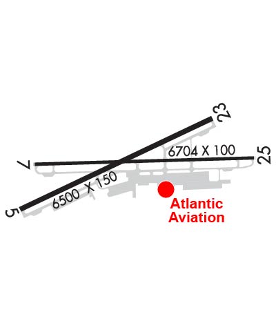

Sunrise / Sunset times for FOUR CORNERS RGNL

DateSunriseSunset
04/18/24 Thursday6:3419:51
04/19/24 Friday6:3319:52
04/20/24 Saturday6:3119:53
04/21/24 Sunday6:3019:53
04/22/24 Monday6:2919:54
04/23/24 Tuesday6:2819:55
04/24/24 Wednesday6:2619:56
04/25/24 Thursday6:2519:57
04/26/24 Friday6:2419:58
04/27/24 Saturday6:2319:59
04/28/24 Sunday6:2220:00
04/29/24 Monday6:2020:00
04/30/24 Tuesday6:1920:01
05/01/24 Wednesday6:1820:02

Airport Facilities

Airport Attendance Schedule7 Days A Week 0600-2200
Airport Status OPERATIONAL (This Status can change at any time - please check NOTAMS)
Airport Lighting ScheduleWHEN ATCT CLSD ACTVT REIL RWY 23 & 25; PAPI RWY 05 & 23; VASI RWY 07 & 25; MIRL RWY 05/23 & 07/25 - CTAF. REIL RWY 25 & MIRL RWY 07/25 PRESET LOW INTST.
Airport Storage AvailableTie Downs, Hanger
Extra Services AvailableAir Freight, Air Ambulance, Cargo Handling, Charter, Flight Instruction, Aircraft Rental, Aircraft Sales
Wind IndicatorYES - (lighted)
Control TowerYES
CTAF Frequency118.900
Unicom Frequency122.950
Rotating Beacon ColorWG
Segmented CircleYES
Landing FeeNO

Airport Inspection Data

Airport InspectedFEDERAL - performed by FAA AIRPORTS FIELD PERSONNEL
Inspection Date06/02/2022

Airport Services

Type of Fuel AvailableGrade 100LL, JET A (freeze point -40C), JET A-1 (icing inhibitor, freeze point -50C)
Airframe Repair ServiceMAJOR
Power Plant Repair ServiceMAJOR

Geographic Data

LatitudeN3644.5
LongitudeW10813.8 (ESTIMATED)
Arpt Elevation5506ft (SURVEYED)
Magnetic Variation12E
1 miles NWof FARMINGTON
Traffic Pattern Altitude
Sectional ChartDENVER

Aircraft Data

Operations (Reported)YearlyAvg. Daily
General Aviation Transient 1337337
General Aviation Local 2555070
Air Taxi 591416
Commerical 00
Commuter 00
Military 11523
Aircraft based on Field
General Aviation Singles 90
General Aviation Multi 12
Jet Aircraft 1
General Aviation Helicopters 4
Military Aircraft 0
Gliders 1
Ultralights 3

FAA Services

FSS on field NO
FSS tie-in ALBUQUERQUE
FSS Phone 1-800-WX-BRIEF
Who issues Notams FMN
Notam D service at airport YES
ARTCC Name DENVER

Federal Status

Airport CertificationAIRPORT RECEIVING SCHEDULED AIR CARRIER SERVICE FROM CARRIERS CERTIFICATED BY THE CIVIL AERONAUTICS BOARD
Aircraft Rescue & Firefighting IndexAIRPORT HAS A CERTIFICATE UNDER CFR PART 139
Airport of EntryNo
Custom Landing RightsNo
Joint Civil/MilitaryNo
Military Landing rightsYES

Federal Agreements

NATIONAL PLAN OF INTEGRATED AIRPORT SYSTEMS (NPIAS)
GRANT AGREEMENTS UNDER FAAP/ADAP/AIP
ADVANCE PLANNING AGREEMENT UNDER FAAP
ASSURANCES PURSUANT TO TITLE VI, CIVIL RIGHTS ACT OF 1964

Remarks

FOR CD CTC FARMINGTON ATCT GROUND CONTROL 121.7, WHEN ATCT CLSD CTC DENVER ARTCC AT 303-651-4257
ARPT SURFACE CONDITIONS ARE NOT MONITORED OUTSIDE OF ATTENDED HOURS.
Airport Communications & Frequencies:
ATIS Frequencies:   Hours(local) of Operation: CONTINUOUS
127.15
FARMINGTON Tower Frequencies:   Hours(local) of operation: 0600-2200   
118.9
257.8
FARMINGTON Ground Frequencies:
121.7
Emergency Frequencies:
121.5
243.0
CTAF Frequency:
118.900
Unicom Frequency:
122.950
Remarks
  • APCH/DEP CTL SVC PRVDD BY DENVER ARTCC (ZDV) ON FREQS 118.575/348.7 (FARMINGTON RCAG).
  • ATCT LEASED TO CITY OF FARMINGTON AND OPERATED BY MIDWEST ATC SERVICE INC.
  • Runway Identifications
    Runway Identification: 05/23
    Length: 6501 ft
    Width: 150 ft
    Surface: ASPHALT
    Edge lights: Medium Intensity

    Treatment: GROOVED
    Weight: PCN 29 /F/C/X/T

     Runway: 05   Runway: 23
    Mag heading: 53°Mag heading: 233°
    Rwy Slope: .49% UpRwy Slope: -.49% Down
    Approach: Approach:
    Pattern: Left TrafficPattern: Left Traffic
    Markings: NONPRECISION INSTRUMENTMarkings: NONPRECISION INSTRUMENT
    Marking Condition: GOODMarking Condition: GOOD
    Arresting Dev: Arresting Dev:
    Lat & Long: N3644.2  W10814.5Lat. & Long.: N3644.7  W10813.3
    Elev: 5471.6 ft. MSLElev: 5503.7 ft. MSL
    TCH: 42 ft. AGLTCH: 42 ft. AGL
    Visual Glide Path: 3.00 degreesVisual Glide Path: 3.00 degrees
    Displaced Threshold: NoDisplaced Threshold: 511 feet
    Touchdown Zone: YESTouchdown Zone: YES
    Touchdown Elev.: 5498.0 feetTouchdown Elev.: 5504.5 feet
    Visual Glide Slope: 4-Light PAPI on LEFT side of RunwayVisual Glide Slope: 4-Light PAPI on RIGHT side of Runway
    RVR Equipment: RVR Equipment:
    RVV Equipment: NORVV Equipment: NO
    Approach Lights: Approach Lights:
    REIL: NOREIL: YES
    Centerline Lights: NOCenterline Lights: NO
    Touchdown lights: NOTouchdown lights: NO
    Runway Category: Runway with a Non-precision Approach having visibility minimums greater than 3/4 mileRunway Category: Runway with a Non-precision Approach having visibility minimums greater than 3/4 mile
    Declared Distances: TORA:6501' TODA:6501' ASDA:5590' LDA:5590'Declared Distances: TORA:6501' TODA:6501' ASDA:6101' LDA:5590'
    Runway Identification: 07/25
    Length: 6704 ft
    Width: 100 ft
    Surface: ASPHALT-GOOD CONDITION
    Edge lights: Medium Intensity

    Treatment: POROUS FRICTION COURSE
    Weight: PCN 29 /F/C/X/T

     Runway: 07   Runway: 25
    Mag heading: 76°Mag heading: 256°
    Rwy Slope: .39% UpRwy Slope: -.39% Down
    Approach: Approach: ILS/DME
    Pattern: Left TrafficPattern: Left Traffic
    Markings: PRECISION INSTRUMENTMarkings: PRECISION INSTRUMENT
    Marking Condition: GOODMarking Condition: GOOD
    Arresting Dev: Arresting Dev:
    Lat & Long: N3644.5  W10814.4Lat. & Long.: N3644.5  W10813.0
    Elev: 5476.9 ft. MSLElev: 5502.8 ft. MSL
    TCH: 50 ft. AGLTCH: 55 ft. AGL
    Visual Glide Path: 3.00 degreesVisual Glide Path: 3.00 degrees
    Displaced Threshold: 239 feetDisplaced Threshold: 217 feet
    Touchdown Zone: YESTouchdown Zone: YES
    Touchdown Elev.: 5501.5 feetTouchdown Elev.: 5506.6 feet
    Visual Glide Slope: 4-BOX VASI ON LEFT SIDE OF RUNWAYVisual Glide Slope: 4-BOX VASI ON LEFT SIDE OF RUNWAY
    RVR Equipment: RVR Equipment:
    RVV Equipment: NORVV Equipment: NO
    Approach Lights: Approach Lights:
    REIL: NOREIL: YES
    Centerline Lights: NOCenterline Lights: NO
    Touchdown lights: NOTouchdown lights: NO
    Runway Category: Runway with a Non-precision Approach having visibility minimums greater than 3/4 mileRunway Category: Precision Instrument Runway
    Declared Distances: TORA:6704' TODA:6704' ASDA:6487' LDA:6248'Declared Distances: TORA:6704' TODA:6704' ASDA:6465' LDA:6248'
    C:38/P: