Current Weather/Notams (Metars, TAFs, Notams, NWS Forecast, PIREPS, and nearby weather)
Customs Information Send updates to Support@FltPlan.com
Customs Not Available
Database effective 05/16/2024
Airport Diagram might not be current.
|
| Facility Name: | FORT MORGAN MUNI |
| City Name: | FORT MORGAN |
| County: | MORGAN |
| State abbrev: | CO |
| State Name: | COLORADO |
| | |
| Ownership: | PUBLICLY OWNED |
| Use: | OPEN TO THE PUBLIC |
| Owner's Name: | CITY OF FORT MORGAN |
| Address: | BOX 100 CITY HALL |
| | FORT MORGAN, CO 80701 |
| Owner's Phone: | 970-867-8414 |
| | |
| Manager's Name: | KYLE SCOTT |
| Address: | 23101 HWY 52 |
| | FORT MORGAN, CO 80701 |
| Phone: | 970-867-8414 |
| | |
| FAA Region: | NORTHWEST MOUNTAIN |
| FAA Field Office: | DEN |
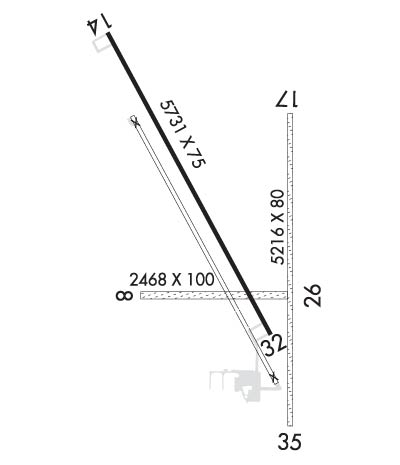
Runway Identifications
Runway Identification: 08/26Length: 2468 ft
Width: 100 ft
Surface: GRASS-FAIR CONDITION
Edge lights: Treatment: NONE
| | Runway: 08 | | Runway: 26 |
| Mag heading: | 82° | Mag heading: | 262° |
| Rwy Slope: | -.12% Down | Rwy Slope: | .12% Up |
| Approach: | | Approach: | |
| Pattern: | Left Traffic | Pattern: | Left Traffic |
| Markings: | | Markings: | |
| Marking Condition: | | Marking Condition: | |
| Arresting Dev: | | Arresting Dev: | |
| Lat & Long: | N4020.0 W10348.6 | Lat. & Long.: | N4020.0 W10348.1 |
| Elev: | 4512.2 ft. MSL | Elev: | 4509.3 ft. MSL |
| TCH: | | TCH: | |
| Visual Glide Path: | | Visual Glide Path: | |
| Displaced Threshold: | No | Displaced Threshold: | No |
| Touchdown Zone: | YES | Touchdown Zone: | YES |
| Touchdown Elev.: | 4512.9 feet | Touchdown Elev.: | 4512.9 feet |
| Visual Glide Slope: | | Visual Glide Slope: | |
| RVR Equipment: | | RVR Equipment: | |
| RVV Equipment: | NO | RVV Equipment: | NO |
| Approach Lights: | | Approach Lights: | |
| REIL: | NO | REIL: | NO |
| Centerline Lights: | NO | Centerline Lights: | NO |
| Touchdown lights: | NO | Touchdown lights: | NO |
| Runway Category: | Runway with a Visual Approach | Runway Category: | Runway with a Visual Approach |
| Declared Distances: | | Declared Distances: | |
| Obstructions: | OTHER; INTERMITTENTLY HAS 5 FT HAY BALES 10 FT FROM AND PARALLEL TO THRESHOLD. | Obstructions: | ROAD |
| Marked: | NOT Marked/Lighted | Marked: | NOT Marked/Lighted |
| Clearance slope: | | Clearance slope: | 8:1 |
| Obstruction height: | 10 feet AGL | Obstruction height: | 18 feet AGL |
| Dist. from runway: | 10 feet | Dist. from runway: | 151 feet |
| Centerline offset: | | Centerline offset: | |
| Comments: | | Comments: | |
Runway Identification: 14/32Length: 5731 ft
Width: 75 ft
Surface: ASPHALT-GOOD CONDITION
Edge lights: Medium IntensityTreatment: NONE
| | Runway: 14 | | Runway: 32 |
| Mag heading: | 143° | Mag heading: | 323° |
| Rwy Slope: | -1.50% Down | Rwy Slope: | 1.50% Up |
| Approach: | | Approach: | |
| Pattern: | Left Traffic | Pattern: | Left Traffic |
| Markings: | NONPRECISION INSTRUMENT | Markings: | NONPRECISION INSTRUMENT |
| Marking Condition: | GOOD | Marking Condition: | GOOD |
| Arresting Dev: | | Arresting Dev: | |
| Lat & Long: | N4020.7 W10348.7 | Lat. & Long.: | N4019.9 W10348.1 |
| Elev: | 4595.3 ft. MSL | Elev: | 4509.3 ft. MSL |
| TCH: | 28 ft. AGL | TCH: | 27 ft. AGL |
| Visual Glide Path: | 3.00 degrees | Visual Glide Path: | 3.00 degrees |
| Displaced Threshold: | No | Displaced Threshold: | No |
| Touchdown Zone: | YES | Touchdown Zone: | YES |
| Touchdown Elev.: | 4595.3 feet | Touchdown Elev.: | 4545.8 feet |
| Visual Glide Slope: | 2-Light PAPI on LEFT side of Runway | Visual Glide Slope: | 2-Light PAPI on LEFT side of Runway |
| RVR Equipment: | | RVR Equipment: | |
| RVV Equipment: | NO | RVV Equipment: | NO |
| Approach Lights: | | Approach Lights: | |
| REIL: | YES | REIL: | YES |
| Centerline Lights: | NO | Centerline Lights: | NO |
| Touchdown lights: | NO | Touchdown lights: | NO |
| Runway Category: | Runway with a Non-precision Approach having visibility minimums greater than 3/4 mile | Runway Category: | Runway with a Non-precision Approach having visibility minimums greater than 3/4 mile |
| Declared Distances: | | Declared Distances: | |
| Obstructions: | | Obstructions: | ROAD |
| Marked: | | Marked: | NOT Marked/Lighted |
| Clearance slope: | 50:1 | Clearance slope: | 11:1 |
| Obstruction height: | | Obstruction height: | 17 feet AGL |
| Dist. from runway: | | Dist. from runway: | 393 feet |
| Centerline offset: | | Centerline offset: | 298 feet right of centerline |
| Comments: | | Comments: | |
Runway Identification: 17/35Length: 5216 ft
Width: 80 ft
Surface: GRASS NATURAL SOIL-FAIR CONDITION
Edge lights: Treatment: NONE
| | Runway: 17 | | Runway: 35 |
| Mag heading: | 172° | Mag heading: | 352° |
| Rwy Slope: | -.55% Down | Rwy Slope: | .55% Up |
| Approach: | | Approach: | |
| Pattern: | Left Traffic | Pattern: | Left Traffic |
| Markings: | | Markings: | |
| Marking Condition: | | Marking Condition: | |
| Arresting Dev: | | Arresting Dev: | |
| Lat & Long: | N4020.5 W10348.0 | Lat. & Long.: | N4019.6 W10348.0 |
| Elev: | 4530.7 ft. MSL | Elev: | 4501.8 ft. MSL |
| TCH: | | TCH: | |
| Visual Glide Path: | | Visual Glide Path: | |
| Displaced Threshold: | No | Displaced Threshold: | No |
| Touchdown Zone: | YES | Touchdown Zone: | YES |
| Touchdown Elev.: | 4530.8 feet | Touchdown Elev.: | 4509.0 feet |
| Visual Glide Slope: | | Visual Glide Slope: | |
| RVR Equipment: | | RVR Equipment: | |
| RVV Equipment: | NO | RVV Equipment: | NO |
| Approach Lights: | | Approach Lights: | |
| REIL: | NO | REIL: | NO |
| Centerline Lights: | NO | Centerline Lights: | NO |
| Touchdown lights: | NO | Touchdown lights: | NO |
| Runway Category: | Runway with a Visual Approach | Runway Category: | Runway with a Visual Approach |
| Declared Distances: | | Declared Distances: | |
| Obstructions: | | Obstructions: | ROAD |
| Marked: | | Marked: | NOT Marked/Lighted |
| Clearance slope: | 50:1 | Clearance slope: | |
| Obstruction height: | | Obstruction height: | 10 feet AGL |
| Dist. from runway: | | Dist. from runway: | 9 feet |
| Centerline offset: | | Centerline offset: | |
| Comments: | | Comments: | |

