Current Weather/Notams (Metars, TAFs, Notams, NWS Forecast, PIREPS, and nearby weather)
Customs Information Send updates to Support@FltPlan.com
Customs Not Available
Database effective 04/18/2024
Airport Diagram might not be current.
|
| Facility Name: | MEADOW LAKE |
| City Name: | COLORADO SPRINGS |
| County: | EL PASO |
| State abbrev: | CO |
| State Name: | COLORADO |
| | |
| Ownership: | PRIVATELY OWNED |
| Use: | OPEN TO THE PUBLIC |
| Owner's Name: | MEADOW LAKE AIRPORT ASSOC., INC.; DAVE ELLIOTT ASSOCIATION PRESIDENT. |
| Address: | 13625 JUDGE ORR ROAD |
| | PEYTON, CO 80831 |
| Owner's Phone: | 719-339-0928 |
| | |
| Manager's Name: | DAVE ELLIOTT |
| Address: | 13625 JUDGE ORR ROAD |
| | PEYTON, CO 80831 |
| Phone: | 719-339-0928; ALTN PHONE IS MIKE BARR AT (719) 287-4204 |
| | |
| FAA Region: | NORTHWEST MOUNTAIN |
| FAA Field Office: | DEN |
Runway Identifications
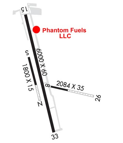
Runway Identification: 08/26Length: 2126 ft
Width: 35 ft
Surface: ASPHALT-GOOD CONDITION-FAIR CONDITION
Edge lights: Treatment: NONE
| | Runway: 08 | | Runway: 26 |
| Mag heading: | 84° | Mag heading: | 264° |
| Rwy Slope: | -1.19% Down | Rwy Slope: | 1.19% Up |
| Approach: | | Approach: | |
| Pattern: | Right Traffic | Pattern: | Left Traffic |
| Markings: | NONE | Markings: | NONE |
| Marking Condition: | POOR | Marking Condition: | POOR |
| Arresting Dev: | | Arresting Dev: | |
| Lat & Long: | N3856.8 W10434.2 | Lat. & Long.: | N3856.8 W10433.8 |
| Elev: | 6824.8 ft. MSL | Elev: | 6799.4 ft. MSL |
| TCH: | | TCH: | |
| Visual Glide Path: | | Visual Glide Path: | |
| Displaced Threshold: | No | Displaced Threshold: | No |
| Touchdown Zone: | YES | Touchdown Zone: | YES |
| Touchdown Elev.: | 6824.8 feet | Touchdown Elev.: | 6824.8 feet |
| Visual Glide Slope: | | Visual Glide Slope: | |
| RVR Equipment: | | RVR Equipment: | |
| RVV Equipment: | NO | RVV Equipment: | NO |
| Approach Lights: | | Approach Lights: | |
| REIL: | NO | REIL: | NO |
| Centerline Lights: | NO | Centerline Lights: | NO |
| Touchdown lights: | NO | Touchdown lights: | NO |
| Runway Category: | Runway with a Visual Approach | Runway Category: | Runway with a Visual Approach |
| Declared Distances: | | Declared Distances: | |
| Obstructions: | | Obstructions: | ROAD |
| Marked: | | Marked: | NOT Marked/Lighted |
| Clearance slope: | 20:1 | Clearance slope: | 1:1 |
| Obstruction height: | | Obstruction height: | 10 feet AGL |
| Dist. from runway: | | Dist. from runway: | 0 feet |
| Centerline offset: | | Centerline offset: | |
| Comments: | | Comments: | |
Runway Identification: 15/33Length: 6001 ft
Width: 60 ft
Surface: ASPHALT
Edge lights: Medium IntensityTreatment: NONE
| | Runway: 15 | | Runway: 33 |
| Mag heading: | 153° | Mag heading: | 333° |
| Rwy Slope: | -1.44% Down | Rwy Slope: | 1.44% Up |
| Approach: | | Approach: | |
| Pattern: | Left Traffic | Pattern: | Right Traffic |
| Markings: | NONPRECISION INSTRUMENT | Markings: | NONPRECISION INSTRUMENT |
| Marking Condition: | POOR | Marking Condition: | POOR |
| Arresting Dev: | | Arresting Dev: | |
| Lat & Long: | N3857.2 W10434.5 | Lat. & Long.: | N3856.3 W10434.1 |
| Elev: | 6878.1 ft. MSL | Elev: | 6791.4 ft. MSL |
| TCH: | 42 ft. AGL | TCH: | 39 ft. AGL |
| Visual Glide Path: | 3.50 degrees | Visual Glide Path: | 3.00 degrees |
| Displaced Threshold: | No | Displaced Threshold: | No |
| Touchdown Zone: | YES | Touchdown Zone: | YES |
| Touchdown Elev.: | 6878.1 feet | Touchdown Elev.: | 6826.0 feet |
| Visual Glide Slope: | 2-Light PAPI on LEFT side of Runway | Visual Glide Slope: | 2-Light PAPI on LEFT side of Runway |
| RVR Equipment: | | RVR Equipment: | |
| RVV Equipment: | NO | RVV Equipment: | NO |
| Approach Lights: | | Approach Lights: | |
| REIL: | YES | REIL: | YES |
| Centerline Lights: | NO | Centerline Lights: | NO |
| Touchdown lights: | NO | Touchdown lights: | NO |
| Runway Category: | Runway with a Visual Approach | Runway Category: | Runway with a Visual Approach |
| Declared Distances: | | Declared Distances: | |
| Obstructions: | ROAD | Obstructions: | |
| Marked: | NOT Marked/Lighted | Marked: | |
| Clearance slope: | 19:1 | Clearance slope: | 20:1 |
| Obstruction height: | 18 feet AGL | Obstruction height: | |
| Dist. from runway: | 558 feet | Dist. from runway: | |
| Centerline offset: | 115 left of centerline | Centerline offset: | |
| Comments: | | Comments: | |
Runway Identification: 16/34Length: 5001 ft
Width: 200 ft
Surface: GRASS-FAIR CONDITION
Edge lights: Treatment: NONE
| | Runway: 16 | | Runway: 34 |
| Mag heading: | 153° | Mag heading: | 333° |
| Rwy Slope: | .00% | Rwy Slope: | .00% |
| Approach: | | Approach: | |
| Pattern: | Left Traffic | Pattern: | Left Traffic |
| Markings: | NONE | Markings: | NONE |
| Marking Condition: | POOR | Marking Condition: | POOR |
| Arresting Dev: | | Arresting Dev: | |
| Lat & Long: | N3856.7 W10434.4 | Lat. & Long.: | N3855.9 W10434.0 |
| Elev: | 6776.8 ft. MSL | Elev: | 6776.8 ft. MSL |
| TCH: | | TCH: | |
| Visual Glide Path: | | Visual Glide Path: | |
| Displaced Threshold: | No | Displaced Threshold: | No |
| Touchdown Zone: | YES | Touchdown Zone: | YES |
| Touchdown Elev.: | 6833.5 feet | Touchdown Elev.: | 6812.2 feet |
| Visual Glide Slope: | | Visual Glide Slope: | |
| RVR Equipment: | | RVR Equipment: | |
| RVV Equipment: | NO | RVV Equipment: | NO |
| Approach Lights: | | Approach Lights: | |
| REIL: | NO | REIL: | NO |
| Centerline Lights: | NO | Centerline Lights: | NO |
| Touchdown lights: | NO | Touchdown lights: | NO |
| Runway Category: | Runway with a Visual Approach | Runway Category: | Runway with a Visual Approach |
| Declared Distances: | | Declared Distances: | |
| Obstructions: | Unknown | Obstructions: | |
| Marked: | NOT Marked/Lighted | Marked: | |
| Clearance slope: | 11:1 | Clearance slope: | 20:1 |
| Obstruction height: | 5 feet AGL | Obstruction height: | |
| Dist. from runway: | 56 feet | Dist. from runway: | |
| Centerline offset: | 79 | Centerline offset: | |
| Comments: | | Comments: | |