Click here for more info on on SMS!

KFLO

FLORENCE RGNL
FLORENCE
SC
Time Zone: Eastern
Lat: N 3411.1
Long: W 07943.4
Elev: 147
Var: +09
Longest Runway: 6502
Clr Del: 121.9
Dept. ATIS: 123.62
Arr. ATIS: 123.62
AWOS: 123.62
Ground: 121.9
Tower: 125.1

FBO & Flight Services info for KFLO

FBOs: Update your Fuel Prices

PRECISION AIR INCPh: 843-667-9627 Fax: 843-667-9838 Freq: 122.95
Service
Jet
100LL
SAF
MoGas
Fuel Avail: 843-409-4556 after hours
Full6.056.85    Last Update: 04/15/2024 10:08

PRIST PREMIXED
Self  6.48    
 Address: 500 S MCCALL BLVD,   FLORENCE, SC 29506
ASOSPh: 843-665-1306
-
-
 
If you are an FBO, call 1-203-262-1700 to update your info or email: FltPlan.Advertising@garmin.com
Advertise your FBO on FltPlan.com

Runway & Approach Info for KFLO
Rwy
Length
Land Dist**
Approach*
  Rwy
Length
Land Dist**
Approach*
01
6000x150  6000'          
 
  
19
  6000x150  6000'          
 
09
6502x150  6502'          
ILS/DME
 109.10 - 092°  
  
27
  6502x150  6502'          
 
 * only ILS, LOC, LDA, and SDF approaches to a specific runway are shown
** For any Declared Landing Distance Available, please see A/FD or Approach plates
Runway Weight Capability (lbs.) Help
Runway IDSingle WheelDouble WheelDouble Tandem WheelDual Double Wheel
01/1987,000139,000238,000N/A
09/2797,000156,000261,000N/A
These numbers are Advisory and are not limits.   The Airport Manager should have more accurate Weight Limits
Approach Charts
Approaches    
Current Weather/Notams
Customs Information Send updates to Support@FltPlan.com
Customs Not Available
Database effective 05/16/2024
Airport Diagram of KFLO
Airport Diagram might not be current.

Facility Name: FLORENCE RGNL
City Name: FLORENCE
County: FLORENCE
State abbrev: SC
State Name: SOUTH CAROLINA
   
Ownership: PUBLICLY OWNED
Use: OPEN TO THE PUBLIC
Owner's Name: PEE DEE REGIONAL ARPT AUTHORITY
Address: 2100 TERMINAL DRIVE
 FLORENCE, SC 29506
Owner's Phone: 843-669-5001
  
Manager's Name: CONNIE G. ANDERSON
Address: 2100 TERMINAL DRIVE
 FLORENCE, SC 29506
Phone: 843-669-5001
   
FAA Region: SOUTHERN
FAA Field Office: ATL


Sunrise / Sunset times for FLORENCE RGNL

DateSunriseSunset
04/24/24 Wednesday6:3619:58
04/25/24 Thursday6:3519:59
04/26/24 Friday6:3420:00
04/27/24 Saturday6:3320:00
04/28/24 Sunday6:3220:01
04/29/24 Monday6:3120:02
04/30/24 Tuesday6:3020:03
05/01/24 Wednesday6:2920:04
05/02/24 Thursday6:2820:04
05/03/24 Friday6:2720:05
05/04/24 Saturday6:2620:06
05/05/24 Sunday6:2520:07
05/06/24 Monday6:2420:08
05/07/24 Tuesday6:2320:08

Airport Facilities

Airport Attendance Schedule7 Days A Week 0630-2200
Airport Status OPERATIONAL (This Status can change at any time - please check NOTAMS)
Airport Lighting ScheduleWHEN ATCT CLSD ACTVT MALSR RWY 09; REIL RWY 01, 19 & 27; PAPI RWY 01 & 19; HIRL RWY 09/27; AND TWY LGTS - CTAF.
Airport Storage AvailableTie Downs, Hanger
Extra Services AvailableCargo Handling, Flight Instruction, Aircraft Rental
Wind IndicatorYES - (lighted)
Control TowerYES
CTAF Frequency125.100
Unicom Frequency122.950
Rotating Beacon ColorWG
Segmented CircleYES
Landing FeeNO

Airport Inspection Data

Airport InspectedFEDERAL - performed by FAA AIRPORTS FIELD PERSONNEL
Inspection Date03/01/2023

Airport Services

Type of Fuel AvailableGrade 100LL, JET A (freeze point -40C)
Airframe Repair ServiceMAJOR
Power Plant Repair ServiceMAJOR

Geographic Data

LatitudeN3411.1
LongitudeW07943.4 (ESTIMATED)
Arpt Elevation146ft (SURVEYED)
Magnetic Variation09W
3 miles Eof FLORENCE
Traffic Pattern Altitude
Sectional ChartCHARLOTTE

Aircraft Data

Operations (Reported)YearlyAvg. Daily
General Aviation Transient 1557643
General Aviation Local 1167832
Air Taxi 357710
Commerical 340
Commuter 00
Military 17285
Aircraft based on Field
General Aviation Singles 25
General Aviation Multi 14
Jet Aircraft 2
General Aviation Helicopters 6
Military Aircraft 0
Gliders 0
Ultralights 0

FAA Services

FSS on field NO
FSS tie-in ANDERSON
FSS Phone 1-800-WX-BRIEF
Who issues Notams FLO
Notam D service at airport YES
ARTCC Name JACKSONVILLE

Federal Status

Airport CertificationAIRPORT RECEIVING SCHEDULED AIR CARRIER SERVICE FROM CARRIERS CERTIFICATED BY THE CIVIL AERONAUTICS BOARD
Aircraft Rescue & Firefighting IndexAIRPORT HAS A CERTIFICATE UNDER CFR PART 139
Airport of EntryNo
Custom Landing RightsNo
Joint Civil/MilitaryNo
Military Landing rightsYES

Federal Agreements

NATIONAL PLAN OF INTEGRATED AIRPORT SYSTEMS (NPIAS)
GRANT AGREEMENTS UNDER FAAP/ADAP/AIP
SURPLUS PROPERTY AGREEMENT UNDER REGULATION 16-WAA
ASSURANCES PURSUANT TO TITLE VI, CIVIL RIGHTS ACT OF 1964
AGREEMENT UNDER DLAND OR DCLA HAS EXPIRED.

Remarks

24 HR PPR FOR UNSKED ACR OPNS WITH MORE THAN 30 PSGR SEATS; CTC AMGR AT 843-669-5001.
FOR CD IF UNA TO CTC ON FSS FREQ, CTC FLORENCE APCH AT 843-665-0632, WHEN APCH CLSD CTC JACKSONVILLE ARTCC AT 904-845-1592.
Airport Communications & Frequencies:
ATIS Frequencies:   Hours(local) of Operation: CONTINUOUS
123.625
FLORENCE Tower Frequencies:   Hours(local) of operation: 0630-2200   
125.1
353.85
FLORENCE Ground Frequencies:
121.9
353.85
Clearance Delivery Frequencies:
121.9
353.85
CTAF Frequency:
125.100
Unicom Frequency:
122.950
Remarks
  • APCH/DEP SVC PRVDD BY JACKSONVILLE ARTCC ON FREQS 133.45/306.3 (FLORENCE RCAG) WHEN FLORENCE APCH CTL CLSD.
  • FLORENCE Primary Approach Frequencies:   Hours(local) of operation: 0630-2200   
    118.6 ;256-074
    135.25 ;075-255
    316.15 ;075-255
    341.7 ;256-074
    FLORENCE Primary Departure Frequencies:   Hours(local) of operation: 0630-2200   
    118.6 ;256-074
    135.25 ;075-255
    316.15 ;075-255
    341.7 ;256-074
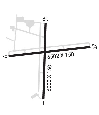
    Runway Identifications
    Runway Identification: 01/19
    Length: 6000 ft
    Width: 150 ft
    Surface: ASPHALT-FAIR CONDITION
    Edge lights: Medium Intensity

    Treatment: NONE
    Weight: PCN 34 /F/B/Y/T

     Runway: 01   Runway: 19
    Mag heading: 10°Mag heading: 190°
    Rwy Slope: .52% UpRwy Slope: -.52% Down
    Approach: Approach:
    Pattern: Left TrafficPattern: Left Traffic
    Markings: NONPRECISION INSTRUMENTMarkings: NONPRECISION INSTRUMENT
    Marking Condition: FAIRMarking Condition: GOOD
    Arresting Dev: Arresting Dev:
    Lat & Long: N3410.6  W07943.5Lat. & Long.: N3411.6  W07943.5
    Elev: 112.2 ft. MSLElev: 143.4 ft. MSL
    TCH: 63 ft. AGLTCH: 32 ft. AGL
    Visual Glide Path: 3.00 degreesVisual Glide Path: 3.00 degrees
    Displaced Threshold: NoDisplaced Threshold: No
    Touchdown Zone: YESTouchdown Zone: YES
    Touchdown Elev.: 134.1 feetTouchdown Elev.: 143.6 feet
    Visual Glide Slope: 4-Light PAPI on LEFT side of RunwayVisual Glide Slope: 4-Light PAPI on LEFT side of Runway
    RVR Equipment: RVR Equipment:
    RVV Equipment: NORVV Equipment: NO
    Approach Lights: Approach Lights:
    REIL: YESREIL: YES
    Centerline Lights: NOCenterline Lights: NO
    Touchdown lights: NOTouchdown lights: NO
    Runway Category: Runway with a Non-precision Approach having visibility minimums greater than 3/4 mileRunway Category: Runway with a Non-precision Approach having visibility minimums greater than 3/4 mile
    Declared Distances: Declared Distances:
    Obstructions: TREEObstructions: TREES
    Marked: NOT Marked/LightedMarked: NOT Marked/Lighted
    Clearance slope: 25:1Clearance slope: 20:1
    Obstruction height: 42 feet AGLObstruction height: 90 feet AGL
    Dist. from runway: 1250 feetDist. from runway: 2000 feet
    Centerline offset: Centerline offset:
    Comments: Comments:
    Runway Identification: 09/27
    Length: 6502 ft
    Width: 150 ft
    Surface: ASPHALT-GOOD CONDITION
    Edge lights: High Intensity

    Treatment: GROOVED
    Weight: PCN 38 /F/B/X/T

     Runway: 09   Runway: 27
    Mag heading: 93°Mag heading: 273°
    Rwy Slope: -.38% DownRwy Slope: .38% Up
    Approach: ILS/DMEApproach:
    Pattern: Left TrafficPattern: Left Traffic
    Markings: PRECISION INSTRUMENTMarkings: NONPRECISION INSTRUMENT
    Marking Condition: GOODMarking Condition: GOOD
    Arresting Dev: Arresting Dev:
    Lat & Long: N3411.1  W07944.0Lat. & Long.: N3411.2  W07942.8
    Elev: 146.5 ft. MSLElev: 121.5 ft. MSL
    TCH: 58 ft. AGLTCH: 46 ft. AGL
    Visual Glide Path: 3.00 degreesVisual Glide Path: 3.00 degrees
    Displaced Threshold: NoDisplaced Threshold: No
    Touchdown Zone: YESTouchdown Zone: YES
    Touchdown Elev.: 146.6 feetTouchdown Elev.: 138.6 feet
    Visual Glide Slope: 4-Light PAPI on LEFT side of RunwayVisual Glide Slope: 4-Light PAPI on LEFT side of Runway
    RVR Equipment: RVR Equipment:
    RVV Equipment: NORVV Equipment: NO
    Approach Lights: MALSR - 1,400 foot medium intensity approach lighting system with runway alignment indicator lightsApproach Lights:
    REIL: NOREIL: YES
    Centerline Lights: NOCenterline Lights: NO
    Touchdown lights: NOTouchdown lights: NO
    Runway Category: Precision Instrument RunwayRunway Category: Runway with a Non-precision Approach having visibility minimums greater than 3/4 mile
    Declared Distances: Declared Distances:
    C:30/P: