Customs - Maintenance - Concierge Services

KFLL

FORT LAUDERDALE/HOLLYWOOD INTL
FORT LAUDERDALE
FL
Time Zone: Eastern
Lat: N 2604.3
Long: W 08009.0
Elev: 65
Var: +06
Longest Runway: 9000
Clr Del: 128.4
Dept. ATIS: 135.0
Arr. ATIS: 135.0
Ground: 121.4/121.7
Tower: 119.3/120.2

FBO & Flight Services info for KFLL

FBOs: Update your Fuel Prices

  click here  
At Jetscape you won't pay extraordinary prices for extraordinary service. You will experience miles of smiles, from touchdown to takeoff. Our happy employees make happy customers & that's what it's all about! You will feel the difference as soon as you taxi over; from the expert ramp handling, to the warm, friendly greeting you & your passengers receive. Escape the Ordinary & come to Jetscape.
Ph: 954-359-9991 Fax: 954-359-8100 Freq: 130.92WebsiteE-Mail
                     
Service
Jet
100LL
SAF
MoGas
Fuel Avail: WE FUEL AT CUSTOMS 24/7.
Full5.937.18    Last Update: 04/09/2024 07:17

***ASK FOR OUR 1ST TIME SPECIAL***
Self        
Misc. Info: Find out about our Weekly Specials. Call the FBO to learn more!Address: 240 SW 34TH ST,   FT. LAUDERDALE, FL 33315

  click here  
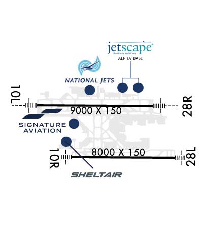
Services include: DCA Gateway, outside the presidential TFR, direct access to new 8000' runway, 24-hour on-site U.S. Customs, superior ground support/concierge services, complimentary interior cleaning, catering, crew cars, on-site cafe, complimentary refreshments, executive conference rooms, pilot lounge, extensive hangar/ramp capacity, a gym & sauna, and your official gateway to the Bahamas.
Ph: 800-394-5388 Fax: 954-359-3211 Freq: 130.1WebsiteE-Mail
                     
Service
Jet
100LL
SAF
MoGas
Fuel Avail: Prist + $0.07
Full6.898.84    Last Update: 04/23/2024 08:31
PRICES GUARANTEED by FBO.
Self        
Misc. Info: On-Site Customs! Call us for special fuel pricing!Address: 1100 LEE WAGENER BLVD.   FT. LAUDERDALE, FL 33315

  click here  
Often called the 'Yachting Capital of the World,' Fort Lauderdale (FLL) is home to Port Everglades, one of the nation's busiest container centers, making FLL a major distribution center. The city also features endless beaches and perfect weather. Whether your plans include catching some Florida-style rays or attending to business, Signature-FLL can take care of your executive aviation needs.
Ph: 954-359-0000 Fax: 954-359-2765 Freq: 129.72WebsiteE-Mail
Service
Jet
100LL
SAF
MoGas
Fuel Avail: Prist +$0.06/gal
Full6.278.37    Last Update: 04/26/2024 10:15

Self        
Misc. Info: Address: 4050 S.W. 11TH TERRACE,   FT. LAUDERDALE, FL 33315

  click here  
Family owned since 1947, providing family friendly, professional, and award-winning line services. Voted #2 Best Line Service in the US in BAN and #4 Best Line Service in the US in AIN 2023 pilot survveys. Open 24/7. Fuel, QTA & passenger services at Customs. NATA Safety 1st Certified Line service. An AEG Connect FBO. A 145 Repair Station with AOG support. Aircraft Charter & Aircraft Management.
Ph: 954-359-9900 Fax: 954-359-0064 Freq: 132.0WebsiteE-Mail
                   
Service
Jet
100LL
SAF
MoGas
Fuel Avail: Open 24/7/365
Full5.907.15    Last Update: 04/24/2024 11:03
PRICES GUARANTEED by FBO.
Self        
Misc. Info: Free 1 day parking with minimum uplift. Contract fuel pricing available.Address: 3495 SW 9TH AVENUE,   FT. LAUDERDALE, FL 33315

If you are an FBO, call 1-203-262-1700 to update your info or email: FltPlan.Advertising@garmin.com
Advertise your FBO on FltPlan.com
FBOs at nearby airports who want your business:
KFXE


  click here  
Avoid frequent traffic delays at FLL. Choose Banyan Air Service at FXE for fast, friendly, personalized service. Banyan is a 24-hour award winning FBO also providing turbine airframe/engine maintenance, avionics service, aircraft sales and hangar storage. FXE is a port of entry and gateway to the Bahamas, the Caribbean and Latin America. U.S. Customs open 8AM-midnight daily.
Ph: 954-491-3170 WebsiteE-MailFax: 954-771-0281 Freq: 130.8

Runway & Approach Info for KFLL
Rwy
Length
Land Dist**
Approach*
  Rwy
Length
Land Dist**
Approach*
10L
9000x150  8424'          
ILS/DME
 110.10 - 096°  
  
28R
  9000x150  8394'          
ILS/DME
 110.70 - 276°  
10R
8000x150  8000'          
ILS/DME
 111.75 - 096°  
  
28L
  8000x150  8000'          
ILS/DME
 111.75 - 276°  
 * only ILS, LOC, LDA, and SDF approaches to a specific runway are shown
** For any Declared Landing Distance Available, please see A/FD or Approach plates
Runway Weight Capability (lbs.) Help
Runway IDSingle WheelDouble WheelDouble Tandem WheelDual Double Wheel
10L/28R100,000200,000468,000800,000
10R/28L120,000247,000461,000987,000
These numbers are Advisory and are not limits.   The Airport Manager should have more accurate Weight Limits
Approach Charts
Approaches    
Current Weather/Notams
Customs Information Send updates to Support@FltPlan.com
Phone 954-359-1160
Fax 954-359-2804

Comments Sun-Sat open 24 HOURS *1 hr advance notice required *Maximum passengers per flight: 20 *Prior arrangements required
Database effective 05/16/2024
Airport Diagram of KFLL
Airport Diagram might not be current.

Facility Name: FORT LAUDERDALE/HOLLYWOOD INTL
City Name: FORT LAUDERDALE
County: BROWARD
State abbrev: FL
State Name: FLORIDA
   
Ownership: PUBLICLY OWNED
Use: OPEN TO THE PUBLIC
Owner's Name: BROWARD COUNTY
Address: 115 S. ANDREWS AVENUE, ROOM 421
 DANIA BEACH, FL 33312-1872
Owner's Phone: 954-359-6100
  
Manager's Name: MARK GALE
Address: 320 TERMINAL DRIVE SUITE 200
 FORT LAUDERDALE, FL 33315
Phone: 954-359-6100
   
FAA Region: SOUTHERN
FAA Field Office: ORL


Sunrise / Sunset times for FORT LAUDERDALE/HOLLYWOOD INTL

DateSunriseSunset
04/25/24 Thursday6:4819:50
04/26/24 Friday6:4719:50
04/27/24 Saturday6:4619:51
04/28/24 Sunday6:4519:51
04/29/24 Monday6:4419:52
04/30/24 Tuesday6:4419:52
05/01/24 Wednesday6:4319:53
05/02/24 Thursday6:4219:53
05/03/24 Friday6:4119:54
05/04/24 Saturday6:4119:54
05/05/24 Sunday6:4019:55
05/06/24 Monday6:3919:55
05/07/24 Tuesday6:3919:56
05/08/24 Wednesday6:3819:56

Airport Facilities

Airport Attendance ScheduleCONTINUOUS
Airport Status OPERATIONAL (This Status can change at any time - please check NOTAMS)
Airport Lighting ScheduleSS-SR
Airport Storage AvailableTie Downs, Hanger
Extra Services AvailableAir Freight, Air Ambulance, Avionics, Cargo Handling, Charter, Flight Instruction, Aircraft Rental, Aircraft Sales, Annual Surveying
Wind IndicatorYES - (unlit)
Control TowerYES
CTAF Frequency
Unicom Frequency122.950
Rotating Beacon ColorWG
Segmented CircleNO
Landing FeeNO

Airport Inspection Data

Airport InspectedFEDERAL - performed by STATE AERONAUTICAL PERSONNEL
Inspection Date02/08/2024

Airport Services

Type of Fuel AvailableGrade 100LL, JET A (freeze point -40C)
Airframe Repair ServiceMAJOR
Power Plant Repair ServiceMAJOR

Geographic Data

LatitudeN2604.3
LongitudeW08009.0 (ESTIMATED)
Arpt Elevation65ft (SURVEYED)
Magnetic Variation06W
3 miles SWof FORT LAUDERDALE
Traffic Pattern Altitude
Sectional ChartMIAMI

Aircraft Data

Operations (Reported)YearlyAvg. Daily
General Aviation Transient 3313791
General Aviation Local 00
Air Taxi 3098485
Commerical 238055652
Commuter 00
Military 14834
Aircraft based on Field
General Aviation Singles 11
General Aviation Multi 7
Jet Aircraft 80
General Aviation Helicopters 2
Military Aircraft 0
Gliders 0
Ultralights 0

FAA Services

FSS on field NO
FSS tie-in MIAMI
FSS Phone 1-800-WX-BRIEF
Who issues Notams FLL
Notam D service at airport YES
ARTCC Name MIAMI

Federal Status

Airport CertificationAIRPORT RECEIVING SCHEDULED AIR CARRIER SERVICE FROM CARRIERS CERTIFICATED BY THE CIVIL AERONAUTICS BOARD
Aircraft Rescue & Firefighting IndexAIRPORT HAS A CERTIFICATE UNDER CFR PART 139
Airport of EntryYES
Custom Landing RightsNo
Joint Civil/MilitaryNo
Military Landing rightsYES

Federal Agreements

NATIONAL PLAN OF INTEGRATED AIRPORT SYSTEMS (NPIAS)
GRANT AGREEMENTS UNDER FAAP/ADAP/AIP
SURPLUS PROPERTY AGREEMENT UNDER PUBLIC LAW 289
CONVEYANCE UNDER SCETION 16, FEDERAL AIRPORT ACT OF 1946 OR SECTION 23, AIRPORT AND AIRWAY DEVELOPMENT ACT OF 1970
ASSURANCES PURSUANT TO TITLE VI, CIVIL RIGHTS ACT OF 1964

Remarks

CLSD TO ACR TRAINING; LRG ACFT TRNG OVER 58000 LBS MAX CERTD GROSS TKOF WEIGHT; ALL TRNG 2300-0700.
PPR FOR ACFT WITH EXPLOSIVES.
TWY E BTN TWY C & TWY L CLSD TO ACFT WINGSPAN MORE THAN 118 FT EXC 10 MIN PPR 954-816-3179.
ARR FM N & W MNTN 6000 FT UNTIL ABM RWY 28R ON DOWNWIND; ARR FM N MNTN 6000 FT UNTIL ABM RWY 10L ON DOWNWIND.
NO VFR APCHS OR BASE LEGS UNTIL OFFSHORE.
IR CARRIER ACFT USE RAMP PUSH BACK PROCS PRESCRIBED BY ARPT OPS.
EAST SIDE OF CONCOURSE B AVBL TO ACFT WITH WINGSPAN LESS THAN 124.9 FT.
ACFT OPRG FROM TRML 1, 2, 3, 4 MUST CTC RAMP CTL. RAMP CTL EFF - CTC ARPT OPS FOR HRS.
ASDE-X IN USE; OPR PARROT WITH ALT RPRTG MODE & ADS-B (IF EQUIPPED) ENABLED ON ARPT SFCS.
TURB BLW 1000 FT OVR LANDFILL LCTD 2 NM W.
ALL RWYS NOISE SENSITIVE; NOISE ABATEMENT IN EFCT - 954-359-6181.
TWY J BGN TO ELEV 900 FT EAST OF TWY Q. DUE TO ELEV ALL ACFT REMAIN ON CNTRLN; TWY T8 & TAXILANE T NOT ACCESSIBLE FM TWY J.
RWY STATUS LIGHTS IN OPRN.
ACFT LDG RWY 10R & EXITING J9 FOLLOW TWY LEAD OFF LINE ONTO J9.
PREFERENTIAL RWY USE PROGRAM IN EFCT; CTC NOISE ABATEMENT OFFICE.
NMRS TREES SW QUADRANT OF ARPT.
HIGH LIGHT MASTS WNW APCH END RWY 28L.
APN TWY T EAST OF TWY T8 CLSD TO ACFT WINGSPAN MORE THAN 118 FT AND TAIL HEIGHT MORE THAN 45FT EXC ACFT UNDER TOW.
TXL T BTN T7 AND T8 CLSD TO ACFT WINGSPAN MORE THAN 171 FT.
JET RUNUPS NA 2300-0700.
DO NOT MISTAKE TWY B FOR LNDG/TKOF SFC.
TWY A BTN TWY A2 & TWY A3 CLSD TO ACFT WINGSPAN MORE THAN 170 FT & TAIL HGT MORE THAN 59 FT EXC PPR 954-816-3179
TWY B E OF TWY B12 & TXL T E OF TWY T1 CLSD TO ACFT WITH WINGSPAN GTR THAN 118 FT & TAIL HGT GTR THAN 45 FT EXC PPR 954-816-3179.
BIRDS ON & INVOF ARPT; CONCENTRATION OF BIRDS BLW 500 FT 2.0 NM W OF 10L & 10R AER.
RWY 10R/ 28LRWY 10R/28L NRS UNGROOVED AREAS.
RWY 10L/ 28RST 175
Airport Communications & Frequencies:
ATIS Frequencies:   Hours(local) of Operation: CONTINUOUS
135.0
FORT LAUDERDALE Tower Frequencies:   Hours(local) of operation: CONTINUOUS   
119.3
120.2
257.8
FORT LAUDERDALE Ground Frequencies:
121.4
121.7
Clearance Delivery Frequencies:
128.4
Pre-Taxi Clearance Frequencies:
128.4
Unicom Frequency:
122.950
MIAMI Primary Approach Frequencies:  
118.1 271-090 BLW 4000 FT
119.45 5000 FT & ABV
133.775 271-090 4000 FT & ABV
285.6 271-090 4000 FT & ABV
290.325 5000 FT & ABV
306.975 091-270
306.975 4000 FT & BLW
MIAMI Primary Departure Frequencies:  
119.45 5000 FT & ABV
119.7 271-090 BLW 4000 FT
126.05 271-090 4000 FT & ABV
128.6
251.1 271-090 4000 FT & ABV
290.325 5000 FT & ABV
306.3 271-090 BLW 4000 FT
306.975 091-270
306.975 4000 FT & BLW
Class C Frequencies:
119.7 270-090
128.6 091-269
306.3 270-090
306.975 091-269
Runway Identifications
Runway Identification: 10L/28R
Length: 9000 ft
Width: 150 ft
Surface: CONCRETE ASPHALT
Edge lights: High Intensity

Treatment: GROOVED
Weight: PCN 95 /R/B/W/T

 Runway: 10L   Runway: 28R
Mag heading: 96°Mag heading: 276°
Rwy Slope: .00% DownRwy Slope: .00% Up
Approach: ILS/DMEApproach: ILS/DME
Pattern: Left TrafficPattern: Right Traffic
Markings: PRECISION INSTRUMENTMarkings: PRECISION INSTRUMENT
Marking Condition: GOODMarking Condition: GOOD
Arresting Dev: EMAS; ARSTG GEAR/SYS: ENGRD MTRLS ARSTG SYS (EMAS) 409 FT IN LEN BY 170 FT IN WID AT THE DEP END OF RWY 10L.Arresting Dev: EMAS; ARSTG GEAR/SYS: ENGRD MTRLS ARSTG SYS (EMAS) 251 FT IN LEN BY 170 FT IN WID AT THE DEP END OF RWY 28R.
Lat & Long: N2604.6  W08010.0Lat. & Long.: N2604.6  W08008.3
Elev: 5.6 ft. MSLElev: 5.3 ft. MSL
TCH: 66 ft. AGLTCH: 69 ft. AGL
Visual Glide Path: 3.00 degreesVisual Glide Path: 3.00 degrees
Displaced Threshold: 576 feetDisplaced Threshold: 606 feet
Touchdown Zone: YESTouchdown Zone: YES
Touchdown Elev.: 7.1 feetTouchdown Elev.: 6.7 feet
Visual Glide Slope: 4-Light PAPI on LEFT side of RunwayVisual Glide Slope: 4-Light PAPI on LEFT side of Runway
RVR Equipment: TOUCHDOWNRVR Equipment: TOUCHDOWN
RVV Equipment: NORVV Equipment: NO
Approach Lights: MALSR - 1,400 foot medium intensity approach lighting system with runway alignment indicator lightsApproach Lights: MALSR - 1,400 foot medium intensity approach lighting system with runway alignment indicator lights
REIL: NOREIL: NO
Centerline Lights: NOCenterline Lights: NO
Touchdown lights: NOTouchdown lights: NO
Runway Category: Precision Instrument RunwayRunway Category: Precision Instrument Runway
Declared Distances: TORA:9000' TODA:9000' ASDA:9000' LDA:8424'Declared Distances: TORA:9000' TODA:9000' ASDA:9000' LDA:8394'
Obstructions: ROADObstructions: RR
Marked: NOT Marked/LightedMarked: NOT Marked/Lighted
Clearance slope: 10:1; APCH RATIO 50:1 TO DSPLCD THR.Clearance slope: 8:1; APCH RATIO 32:1 TO DSPLCD THR; +43 FT LGTD POLE 1414 FT FM THR 75 FT R; APCH RATIO 46:1.
Obstruction height: 14 feet AGLObstruction height: 33 feet AGL
Dist. from runway: 340 feetDist. from runway: 470 feet
Centerline offset: Centerline offset: 530 feet right of centerline
Comments: +8 FT FENCE 200 FT FM THR & 400 FT R; 40 FT LGT POLES PARL TO RWY BTN TWY Q & A-4 650 FT N.Comments:
Runway Identification: 10R/28L
Length: 8000 ft
Width: 150 ft
Surface: CONCRETE
Edge lights: High Intensity

Treatment: GROOVED
Weight: PCN 74 /R/B/W/T

 Runway: 10R   Runway: 28L
Mag heading: 96°Mag heading: 276°
Rwy Slope: .69% UpRwy Slope: -.69% Down
Approach: ILS/DMEApproach: ILS/DME
Pattern: Right TrafficPattern: Left Traffic
Markings: PRECISION INSTRUMENTMarkings: PRECISION INSTRUMENT
Marking Condition: GOODMarking Condition: GOOD
Arresting Dev: EMAS; ARSTG GEAR/SYS: ENGRD MTRLS ARSTG SYS (EMAS) 562.9 FT IN LEN BY 178.2 FT IN WID AT THE DEP END OF RWY 10R.Arresting Dev: EMAS; ARSTG GEAR/SYS: ENGRD MTRLS ARSTG SYS (EMAS) 562.9 FT IN LEN BY 178.2 FT IN WID AT THE DEP END OF RWY 28L.
Lat & Long: N2604.0  W08009.5Lat. & Long.: N2603.9  W08008.0
Elev: 10.1 ft. MSLElev: 65.0 ft. MSL
TCH: 71 ft. AGLTCH: 69 ft. AGL
Visual Glide Path: 3.00 degreesVisual Glide Path: 3.00 degrees
Displaced Threshold: NoDisplaced Threshold: No
Touchdown Zone: YESTouchdown Zone: YES
Touchdown Elev.: 14.3 feetTouchdown Elev.: 65.0 feet
Visual Glide Slope: 4-Light PAPI on RIGHT side of RunwayVisual Glide Slope: 4-Light PAPI on LEFT side of Runway
RVR Equipment: TOUCHDOWNRVR Equipment: TOUCHDOWN
RVV Equipment: NORVV Equipment: NO
Approach Lights: MALSF - 1,400 foot medium intensity approach lighting system with sequenced flashers; RWY 10R MALSF NSTD; 370 FT GAP BTN 8+00 & STATION 11+70.Approach Lights: MALSF - 1,400 foot medium intensity approach lighting system with sequenced flashers
REIL: NOREIL: NO
Centerline Lights: NOCenterline Lights: NO
Touchdown lights: NOTouchdown lights: NO
Runway Category: Precision Instrument RunwayRunway Category: Precision Instrument Runway
Declared Distances: TORA:8000' TODA:8000' ASDA:8000' LDA:8000'Declared Distances: TORA:8000' TODA:8000' ASDA:8000' LDA:8000'
Obstructions: POLEObstructions:
Marked: LIGHTEDMarked:
Clearance slope: 18:1Clearance slope: 50:1
Obstruction height: 35 feet AGLObstruction height:
Dist. from runway: 865 feetDist. from runway:
Centerline offset: 587 left of centerlineCenterline offset:
Comments: Comments:
C:365/P: