Click here for more info on on SMS!

KFIT

FITCHBURG MUNI
FITCHBURG
MA
Time Zone: Eastern
Lat: N 4233.2
Long: W 07145.6
Elev: 345
Var: +15
Longest Runway: 5001
Clr Del: 603-594-5552
AWOS: 135.17
CTAF: 122.7

FBO & Flight Services info for KFIT

FBOs: Update your Fuel Prices

FITCHBURG MUNPh: 978-345-9580 Fax: 978-345-9579 Freq: 122.7
Service
Jet
100LL
SAF
MoGas
Fuel Avail: PRIST Premixed. Surcharge for After Hours/Discount for Cash, Check or SHELL card.
Full6.006.42    Last Update: 04/21/2024 09:52

Self  6.12    
 Address: 567 CRAWFORD ST,   FITCHBURG, MA 01420
ASOSPh: 978-343-9121
-
Freq: 135.17  
If you are an FBO, call 1-203-262-1700 to update your info or email: FltPlan.Advertising@garmin.com
Advertise your FBO on FltPlan.com

Runway & Approach Info for KFIT
Rwy
Length
Land Dist**
Approach*
  Rwy
Length
Land Dist**
Approach*
14
5001x100  4838'          
 
  
32
  5001x100  4701'          
 
 * only ILS, LOC, LDA, and SDF approaches to a specific runway are shown
** For any Declared Landing Distance Available, please see A/FD or Approach plates
Runway Weight Capability (lbs.) Help
Runway IDSingle WheelDouble WheelDouble Tandem WheelDual Double Wheel
14/3230,00041,000N/AN/A
These numbers are Advisory and are not limits.   The Airport Manager should have more accurate Weight Limits
Approach Charts
Approaches    
Current Weather/Notams
Customs Information Send updates to Support@FltPlan.com
Customs Not Available
Database effective 05/16/2024
Airport Diagram of KFIT
Airport Diagram might not be current.

Facility Name: FITCHBURG MUNI
City Name: FITCHBURG
County: WORCESTER
State abbrev: MA
State Name: MASSACHUSETTS
   
Ownership: PUBLICLY OWNED
Use: OPEN TO THE PUBLIC
Owner's Name: CITY OF FITCHBURG
Address: CITY HALL, 718 MAIN ST
 FITCHBURG, MA 01420
Owner's Phone: 978-829-1800
  
Manager's Name: PETER KETTLE
Address: FITCHBURG MUNICIPAL AIRPORT, 567 CRAWFORD ST
 FITCHBURG, MA 01420
Phone: 978-345-9580; PKETTLE@FITCHBURGMA.GOV.
   
FAA Region: NEW ENGLAND
FAA Field Office: NONE


Sunrise / Sunset times for FITCHBURG MUNI

DateSunriseSunset
04/23/24 Tuesday5:5219:39
04/24/24 Wednesday5:5119:40
04/25/24 Thursday5:4919:41
04/26/24 Friday5:4819:42
04/27/24 Saturday5:4619:43
04/28/24 Sunday5:4519:45
04/29/24 Monday5:4419:46
04/30/24 Tuesday5:4219:47
05/01/24 Wednesday5:4119:48
05/02/24 Thursday5:4019:49
05/03/24 Friday5:3819:50
05/04/24 Saturday5:3719:51
05/05/24 Sunday5:3619:52
05/06/24 Monday5:3419:53

Airport Facilities

Airport Attendance Schedule0800-1700
Airport Status OPERATIONAL (This Status can change at any time - please check NOTAMS)
Airport Lighting ScheduleACTVT REIL RWY 14 & 32; PAPI RWY 14 & 32; MIRL RWY 14/32 - 123.0.
Airport Storage AvailableTie Downs, Hanger
Extra Services AvailableAir Ambulance, Avionics, Charter, Glider, Flight Instruction, Aircraft Rental
Wind IndicatorYES - (unlit)
Control TowerNO
CTAF Frequency122.700
Unicom Frequency122.700
Rotating Beacon ColorWG; ROTG BCN NOT AVBL DURG DALGT IFR CONDS.
Segmented CircleYES
Landing FeeYES; CORPORATE & COML FLTS ONLY.

Airport Inspection Data

Airport InspectedSTATE - performed by STATE AERONAUTICAL PERSONNEL
Inspection Date11/16/2023

Airport Services

Type of Fuel AvailableGrade 100LL, JET A (freeze point -40C), JET A
Airframe Repair ServiceMAJOR
Power Plant Repair ServiceMAJOR

Geographic Data

LatitudeN4233.2
LongitudeW07145.6 (ESTIMATED)
Arpt Elevation344ft (SURVEYED)
Magnetic Variation15W
3 miles SEof FITCHBURG
Traffic Pattern Altitude1002
Sectional ChartNEW YORK

Aircraft Data

Operations (Reported)YearlyAvg. Daily
General Aviation Transient 10003
General Aviation Local 1200033
Air Taxi 1000
Commerical 00
Commuter 00
Military 1000
Aircraft based on Field
General Aviation Singles 100
General Aviation Multi 9
Jet Aircraft 1
General Aviation Helicopters 1
Military Aircraft 0
Gliders 1
Ultralights 2

FAA Services

FSS on field NO
FSS tie-in BRIDGEPORT
FSS Phone 1-800-WX-BRIEF
Who issues Notams FIT
Notam D service at airport YES
ARTCC Name BOSTON

Federal Status

Airport Certification
Aircraft Rescue & Firefighting IndexNone
Airport of EntryNo
Custom Landing RightsNo
Joint Civil/MilitaryNo
Military Landing rightsYES

Federal Agreements

NATIONAL PLAN OF INTEGRATED AIRPORT SYSTEMS (NPIAS)
GRANT AGREEMENTS UNDER FAAP/ADAP/AIP
ASSURANCES PURSUANT TO TITLE VI, CIVIL RIGHTS ACT OF 1964
AGREEMENT UNDER DLAND OR DCLA HAS EXPIRED.

Remarks

WILDLIFE ON & INVOF ARPT.
FOR CD CTC BOSTON APCH AT 603-594-5552.
COLD TEMPERATURE AIRPORT. ALTITUDE CORRECTION REQUIRED AT OR BELOW -22C.
Airport Communications & Frequencies:
CTAF Frequency:
122.700
Unicom Frequency:
122.700
BOSTON Primary Approach Frequencies:  
124.4
279.6
BOSTON Primary Departure Frequencies:  
124.4
279.6
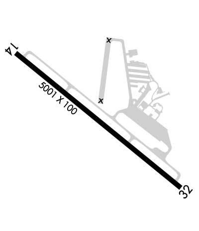
Runway Identifications
Runway Identification: 14/32
Length: 5001 ft
Width: 100 ft
Surface: ASPHALT
Edge lights: Medium Intensity

Treatment: NONE

 Runway: 14   Runway: 32
Mag heading: 145°Mag heading: 325°
Rwy Slope: -.32% DownRwy Slope: .32% Up
Approach: Approach:
Pattern: Left TrafficPattern: Left Traffic
Markings: NONPRECISION INSTRUMENTMarkings: NONPRECISION INSTRUMENT
Marking Condition: GOODMarking Condition: GOOD
Arresting Dev: Arresting Dev:
Lat & Long: N4233.5  W07146.0Lat. & Long.: N4233.0  W07145.1
Elev: 344.5 ft. MSLElev: 328.5 ft. MSL
TCH: 40 ft. AGLTCH: 46 ft. AGL
Visual Glide Path: 3.00 degreesVisual Glide Path: 3.50 degrees
Displaced Threshold: 163 feetDisplaced Threshold: 300 feet
Touchdown Zone: YESTouchdown Zone: YES
Touchdown Elev.: 344.2 feetTouchdown Elev.: 336.6 feet
Visual Glide Slope: 4-Light PAPI on LEFT side of Runway; PAPI UNUSBL BYD 5 DEGS L & R OF CNTRLN.Visual Glide Slope: 4-Light PAPI on LEFT side of Runway
RVR Equipment: RVR Equipment:
RVV Equipment: NORVV Equipment: NO
Approach Lights: Approach Lights:
REIL: YESREIL: YES
Centerline Lights: NOCenterline Lights: NO
Touchdown lights: NOTouchdown lights: NO
Runway Category: Runway with a Non-precision ApproachRunway Category: Runway with a Non-precision Approach
Declared Distances: TORA:5001' TODA:5001' ASDA:4701' LDA:4538'Declared Distances: TORA:5001' TODA:5001' ASDA:4838' LDA:4538'
Obstructions: TREESObstructions: TREES
Marked: NOT Marked/LightedMarked: NOT Marked/Lighted
Clearance slope: 8:1Clearance slope: 14:1
Obstruction height: 50 feet AGLObstruction height: 42 feet AGL
Dist. from runway: 600 feetDist. from runway: 800 feet
Centerline offset: 125 left of centerlineCenterline offset: 125 feet right of centerline
Comments: Comments:
C:6/P: