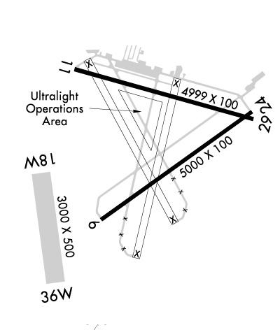
Runway Identification: 06/24Length: 5001 ft
Width: 100 ft
Surface: ASPHALT
Edge lights: Medium IntensityTreatment: GROOVED
Weight: PCN 19 /F/B/Y/T
| | Runway: 06 | | Runway: 24 |
| Mag heading: | 61° | Mag heading: | 241° |
| Rwy Slope: | .03% Up | Rwy Slope: | -.03% Down |
| Approach: | | Approach: | |
| Pattern: | Left Traffic | Pattern: | Left Traffic |
| Markings: | NONPRECISION INSTRUMENT | Markings: | NONPRECISION INSTRUMENT |
| Marking Condition: | GOOD | Marking Condition: | GOOD |
| Arresting Dev: | | Arresting Dev: | |
| Lat & Long: | N2927.6 W08112.7 | Lat. & Long.: | N2928.1 W08112.0 |
| Elev: | 29.6 ft. MSL | Elev: | 31.0 ft. MSL |
| TCH: | 41 ft. AGL | TCH: | 40 ft. AGL |
| Visual Glide Path: | 3.00 degrees | Visual Glide Path: | 3.00 degrees |
| Displaced Threshold: | No | Displaced Threshold: | No |
| Touchdown Zone: | YES | Touchdown Zone: | YES |
| Touchdown Elev.: | 32.9 feet | Touchdown Elev.: | 32.9 feet |
| Visual Glide Slope: | 4-Light PAPI on LEFT side of Runway | Visual Glide Slope: | 4-Light PAPI on LEFT side of Runway |
| RVR Equipment: | | RVR Equipment: | |
| RVV Equipment: | NO | RVV Equipment: | NO |
| Approach Lights: | | Approach Lights: | |
| REIL: | YES | REIL: | YES |
| Centerline Lights: | NO | Centerline Lights: | NO |
| Touchdown lights: | NO | Touchdown lights: | NO |
| Runway Category: | Runway with a Non-precision Approach having visibility minimums greater than 3/4 mile | Runway Category: | Runway with a Non-precision Approach having visibility minimums greater than 3/4 mile |
| Declared Distances: | | Declared Distances: | |
| Obstructions: | TREES | Obstructions: | TREES |
| Marked: | NOT Marked/Lighted | Marked: | NOT Marked/Lighted |
| Clearance slope: | 34:1 | Clearance slope: | 21:1 |
| Obstruction height: | 84 feet AGL | Obstruction height: | 53 feet AGL |
| Dist. from runway: | 3075 feet | Dist. from runway: | 1330 feet |
| Centerline offset: | 315 right of centerline | Centerline offset: | 130 feet left of centerline |
| Comments: | | Comments: | |
Runway Identification: 11/29Length: 5500 ft
Width: 100 ft
Surface: ASPHALT
Edge lights: Medium IntensityTreatment: GROOVED
Weight: PCN 27 /F/A/X/T
| | Runway: 11 | | Runway: 29 |
| Mag heading: | 112° | Mag heading: | 292° |
| Rwy Slope: | .00% Up | Rwy Slope: | .00% Down |
| Approach: | | Approach: | |
| Pattern: | Left Traffic; RWY 11 DSGND CALM WIND RWY FOR ARRS AND DEPS 0300-1100Z. | Pattern: | Left Traffic |
| Markings: | NONPRECISION INSTRUMENT | Markings: | NONPRECISION INSTRUMENT |
| Marking Condition: | FAIR | Marking Condition: | FAIR |
| Arresting Dev: | | Arresting Dev: | |
| Lat & Long: | N2928.2 W08112.8 | Lat. & Long.: | N2928.0 W08111.8 |
| Elev: | 30.8 ft. MSL | Elev: | 30.9 ft. MSL |
| TCH: | 40 ft. AGL | TCH: | 40 ft. AGL |
| Visual Glide Path: | 3.00 degrees | Visual Glide Path: | 3.00 degrees |
| Displaced Threshold: | No | Displaced Threshold: | No |
| Touchdown Zone: | YES | Touchdown Zone: | YES |
| Touchdown Elev.: | 33.1 feet | Touchdown Elev.: | 32.7 feet |
| Visual Glide Slope: | 4-Light PAPI on LEFT side of Runway | Visual Glide Slope: | 4-Light PAPI on LEFT side of Runway |
| RVR Equipment: | | RVR Equipment: | |
| RVV Equipment: | NO | RVV Equipment: | NO |
| Approach Lights: | | Approach Lights: | |
| REIL: | YES | REIL: | YES |
| Centerline Lights: | NO | Centerline Lights: | NO |
| Touchdown lights: | NO | Touchdown lights: | NO |
| Runway Category: | Runway with a Non-precision Approach having visibility minimums greater than 3/4 mile | Runway Category: | Runway with a Non-precision Approach having visibility minimums greater than 3/4 mile |
| Declared Distances: | | Declared Distances: | |
| Obstructions: | TREES | Obstructions: | TREES |
| Marked: | NOT Marked/Lighted | Marked: | NOT Marked/Lighted |
| Clearance slope: | 35:1 | Clearance slope: | 32:1 |
| Obstruction height: | 55 feet AGL | Obstruction height: | 66 feet AGL |
| Dist. from runway: | 2155 feet | Dist. from runway: | 2322 feet |
| Centerline offset: | 250 right of centerline | Centerline offset: | 250 feet right of centerline |
| Comments: | | Comments: | |
Runway Identification: 18W/36WLength: 3001 ft
Width: 500 ft
Surface: WATER
Edge lights: Treatment: NONE
| | Runway: 18W | | Runway: 36W |
| Mag heading: | 179° | Mag heading: | 359° |
| Rwy Slope: | .00% | Rwy Slope: | .00% |
| Approach: | | Approach: | |
| Pattern: | Left Traffic | Pattern: | Left Traffic |
| Markings: | | Markings: | |
| Marking Condition: | | Marking Condition: | |
| Arresting Dev: | | Arresting Dev: | |
| Lat & Long: | N2927.9 W08113.0 | Lat. & Long.: | N2927.4 W08113.0 |
| Elev: | 22.0 ft. MSL | Elev: | 22.0 ft. MSL |
| TCH: | | TCH: | |
| Visual Glide Path: | | Visual Glide Path: | |
| Displaced Threshold: | No | Displaced Threshold: | No |
| Touchdown Zone: | YES | Touchdown Zone: | YES |
| Touchdown Elev.: | 22.0 feet | Touchdown Elev.: | 22.0 feet |
| Visual Glide Slope: | | Visual Glide Slope: | |
| RVR Equipment: | | RVR Equipment: | |
| RVV Equipment: | NO | RVV Equipment: | NO |
| Approach Lights: | | Approach Lights: | |
| REIL: | NO | REIL: | NO |
| Centerline Lights: | NO | Centerline Lights: | NO |
| Touchdown lights: | NO | Touchdown lights: | NO |
| Runway Category: | Runway with a Visual Approach | Runway Category: | Runway with a Visual Approach |
| Declared Distances: | | Declared Distances: | |
Runway Identification: H1 HELIPADLength: 36 ft
Width: 36 ft
Surface: CONCRETE-GOOD CONDITION-FAIR CONDITION
Edge lights:
Treatment: NONE