Current Weather/Notams (Metars, TAFs, Notams, NWS Forecast, PIREPS, and nearby weather)
Customs Information Send updates to Support@FltPlan.com
Customs Not Available
Database effective 04/18/2024
Airport Diagram might not be current.
|
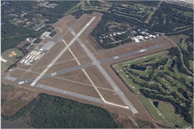
| Facility Name: | FERNANDINA BEACH MUNI |
| City Name: | FERNANDINA BEACH |
| County: | NASSAU |
| State abbrev: | FL |
| State Name: | FLORIDA |
| | |
| Ownership: | PUBLICLY OWNED |
| Use: | OPEN TO THE PUBLIC |
| Owner's Name: | CITY OF FERNANDINA BEACH |
| Address: | 204 ASH ST |
| | FERNANDINA BEACH, FL 32034 |
| Owner's Phone: | 904-310-3101 |
| | |
| Manager's Name: | SAM CARVER |
| Address: | 700 AIRPORT ROAD |
| | FERNANDINA BEACH, FL 32034 |
| Phone: | 904-310-3436 |
| | |
| FAA Region: | SOUTHERN |
| FAA Field Office: | ORL |
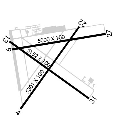
Runway Identifications
Runway Identification: 04/22Length: 5301 ft
Width: 100 ft
Surface: ASPHALT
Edge lights: Medium IntensityTreatment: GROOVED
Weight: PCN 24 /F/B/W/T
| | Runway: 04 | | Runway: 22 |
| Mag heading: | 41° | Mag heading: | 221° |
| Rwy Slope: | .03% Up | Rwy Slope: | -.03% Down |
| Approach: | | Approach: | |
| Pattern: | Left Traffic | Pattern: | Left Traffic |
| Markings: | NONPRECISION INSTRUMENT | Markings: | NONPRECISION INSTRUMENT |
| Marking Condition: | GOOD | Marking Condition: | GOOD |
| Arresting Dev: | | Arresting Dev: | |
| Lat & Long: | N3036.3 W08128.0 | Lat. & Long.: | N3037.0 W08127.4 |
| Elev: | 12.4 ft. MSL | Elev: | 14.2 ft. MSL |
| TCH: | 47 ft. AGL | TCH: | 48 ft. AGL |
| Visual Glide Path: | 3.00 degrees | Visual Glide Path: | 3.00 degrees |
| Displaced Threshold: | No | Displaced Threshold: | 440 feet |
| Touchdown Zone: | YES | Touchdown Zone: | YES |
| Touchdown Elev.: | 14.8 feet | Touchdown Elev.: | 15.7 feet |
| Visual Glide Slope: | 4-Light PAPI on LEFT side of Runway | Visual Glide Slope: | 4-Light PAPI on LEFT side of Runway |
| RVR Equipment: | | RVR Equipment: | |
| RVV Equipment: | NO | RVV Equipment: | NO |
| Approach Lights: | | Approach Lights: | |
| REIL: | YES | REIL: | NO |
| Centerline Lights: | NO | Centerline Lights: | NO |
| Touchdown lights: | NO | Touchdown lights: | NO |
| Runway Category: | Runway with a Non-precision Approach having visibility minimums greater than 3/4 mile | Runway Category: | Runway with a Non-precision Approach having visibility minimums greater than 3/4 mile |
| Declared Distances: | | Declared Distances: | |
| Obstructions: | TREES | Obstructions: | TREES |
| Marked: | NOT Marked/Lighted | Marked: | NOT Marked/Lighted |
| Clearance slope: | 35:1 | Clearance slope: | 20:1; RWY 22, APCH RATIO 35:1 TO DSPLCD THLD. |
| Obstruction height: | 35 feet AGL | Obstruction height: | 45 feet AGL |
| Dist. from runway: | 1445 feet | Dist. from runway: | 1120 feet |
| Centerline offset: | 70 right of centerline | Centerline offset: | 25 feet left of centerline |
| Comments: | | Comments: | |
Runway Identification: 09/27Length: 5000 ft
Width: 100 ft
Surface: CONCRETE-GOOD CONDITION
Edge lights: Medium IntensityTreatment: WIRE COMB OR WIRE TINE
Weight: PCN 29 /R/B/W/T
| | Runway: 09 | | Runway: 27 |
| Mag heading: | 86° | Mag heading: | 266° |
| Rwy Slope: | .02% Up | Rwy Slope: | -.02% Down |
| Approach: | | Approach: | |
| Pattern: | Left Traffic | Pattern: | Left Traffic |
| Markings: | NONPRECISION INSTRUMENT | Markings: | NONPRECISION INSTRUMENT |
| Marking Condition: | FAIR | Marking Condition: | FAIR |
| Arresting Dev: | | Arresting Dev: | |
| Lat & Long: | N3036.8 W08128.1 | Lat. & Long.: | N3036.9 W08127.1 |
| Elev: | 12.3 ft. MSL | Elev: | 13.3 ft. MSL |
| TCH: | 45 ft. AGL | TCH: | 37 ft. AGL |
| Visual Glide Path: | 3.00 degrees | Visual Glide Path: | 3.00 degrees |
| Displaced Threshold: | No | Displaced Threshold: | 699 feet |
| Touchdown Zone: | YES | Touchdown Zone: | YES |
| Touchdown Elev.: | 15.5 feet | Touchdown Elev.: | 15.7 feet |
| Visual Glide Slope: | 4-Light PAPI on LEFT side of Runway | Visual Glide Slope: | 4-Light PAPI on LEFT side of Runway |
| RVR Equipment: | | RVR Equipment: | |
| RVV Equipment: | NO | RVV Equipment: | NO |
| Approach Lights: | | Approach Lights: | |
| REIL: | NO | REIL: | NO |
| Centerline Lights: | NO | Centerline Lights: | NO |
| Touchdown lights: | NO | Touchdown lights: | NO |
| Runway Category: | Runway with a Visual Approach | Runway Category: | Runway with a Visual Approach |
| Declared Distances: | | Declared Distances: | |
| Obstructions: | TREE | Obstructions: | ROAD |
| Marked: | NOT Marked/Lighted | Marked: | NOT Marked/Lighted |
| Clearance slope: | 21:1 | Clearance slope: | 11:1; RWY 27 APCH RATIO 25:1 AT DSPLCD THLD. |
| Obstruction height: | 49 feet AGL | Obstruction height: | 15 feet AGL |
| Dist. from runway: | 1210 feet | Dist. from runway: | 370 feet |
| Centerline offset: | 210 left of centerline | Centerline offset: | 250 feet left of centerline |
| Comments: | | Comments: | |
Runway Identification: 13/31Length: 5152 ft
Width: 100 ft
Surface: ASPHALT-FAIR CONDITION
Edge lights: Medium IntensityTreatment: NONE
Weight: PCN 5 /F/B/Y/T
| | Runway: 13 | | Runway: 31 |
| Mag heading: | 131° | Mag heading: | 311° |
| Rwy Slope: | .04% Up | Rwy Slope: | -.04% Down |
| Approach: | | Approach: | |
| Pattern: | Left Traffic | Pattern: | Left Traffic |
| Markings: | NONPRECISION INSTRUMENT | Markings: | NONPRECISION INSTRUMENT |
| Marking Condition: | FAIR | Marking Condition: | FAIR |
| Arresting Dev: | | Arresting Dev: | |
| Lat & Long: | N3036.9 W08128.1 | Lat. & Long.: | N3036.4 W08127.3 |
| Elev: | 12.2 ft. MSL | Elev: | 14.4 ft. MSL |
| TCH: | 49 ft. AGL | TCH: | |
| Visual Glide Path: | 3.00 degrees | Visual Glide Path: | |
| Displaced Threshold: | No | Displaced Threshold: | 793 feet |
| Touchdown Zone: | YES | Touchdown Zone: | YES |
| Touchdown Elev.: | 14.4 feet | Touchdown Elev.: | 14.6 feet |
| Visual Glide Slope: | 2-Light PAPI on LEFT side of Runway | Visual Glide Slope: | |
| RVR Equipment: | | RVR Equipment: | |
| RVV Equipment: | NO | RVV Equipment: | NO |
| Approach Lights: | | Approach Lights: | |
| REIL: | YES | REIL: | NO |
| Centerline Lights: | NO | Centerline Lights: | NO |
| Touchdown lights: | NO | Touchdown lights: | NO |
| Runway Category: | Runway with a Non-precision Approach having visibility minimums greater than 3/4 mile | Runway Category: | Runway with a Visual Approach |
| Declared Distances: | | Declared Distances: | |
| Obstructions: | TREE | Obstructions: | TREES |
| Marked: | NOT Marked/Lighted | Marked: | NOT Marked/Lighted |
| Clearance slope: | 42:1 | Clearance slope: | 10:1; RWY 31 APCH RATIO 28:1 AT DSPLCD THLD. |
| Obstruction height: | 44 feet AGL | Obstruction height: | 56 feet AGL |
| Dist. from runway: | 2045 feet | Dist. from runway: | 775 feet |
| Centerline offset: | 50 right of centerline | Centerline offset: | |
| Comments: | | Comments: | |