Click here for more info on on SMS!

KFGU

COLLEGEDALE MUNI
COLLEGEDALE
TN
Time Zone: Eastern
Lat: N 3502.7
Long: W 08501.2
Elev: 860
Var: +02
Longest Runway: 4986
AWOS: 122.7
CTAF: 122.7

FBO & Flight Services info for KFGU

FBOs: Update your Fuel Prices

COLLEGEDALE MUNIPh: 423-236-5008 Fax: 423-236-5080 Freq: 122.7
Service
Jet
100LL
SAF
MoGas
Fuel Avail: Jet-A with PRIST Available. $50 after hrs call out fee. AvGas and Jet-A 24/7 self -serv..
Full        Last Update: 03/27/2024 11:04

Self5.555.79    
 Address: 5100 BESS MOORE RD   APISON, TN 37302
AWOSPh: 423-236-4028
-
Freq: 122.7  
If you are an FBO, call 1-203-262-1700 to update your info or email: FltPlan.Advertising@garmin.com
Advertise your FBO on FltPlan.com

Runway & Approach Info for KFGU
Rwy
Length
Land Dist**
Approach*
  Rwy
Length
Land Dist**
Approach*
03
4986x75  4586'          
 
  
21
  4986x75  4986'          
 
 * only ILS, LOC, LDA, and SDF approaches to a specific runway are shown
** For any Declared Landing Distance Available, please see A/FD or Approach plates
Runway Weight Capability (lbs.) Help
Runway IDSingle WheelDouble WheelDouble Tandem WheelDual Double Wheel
03/21N/AN/AN/AN/A
These numbers are Advisory and are not limits.   The Airport Manager should have more accurate Weight Limits
Approach Charts
FltPlan does not have IFR approach charts available for KFGU.
Current Weather/Notams
Customs Information Send updates to Support@FltPlan.com
Customs Not Available
Database effective 04/18/2024
Airport Diagram of KFGU
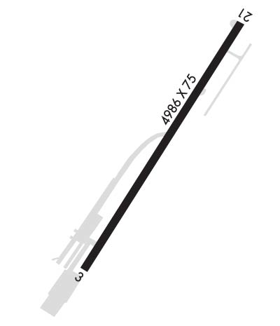
Airport Diagram might not be current.

Facility Name: COLLEGEDALE MUNI
City Name: COLLEGEDALE
County: HAMILTON
State abbrev: TN
State Name: TENNESSEE
   
Ownership: PUBLICLY OWNED
Use: OPEN TO THE PUBLIC
Owner's Name: CITY OF COLLEGEDALE
Address: P.O. BOX 1880
 COLLEGEDALE, TN 37315-1880
Owner's Phone: 423-396-3135
  
Manager's Name: RYAN BYFORD
Address: P.O. BOX 1880
 COLLEGEDALE, TN 37315-1880
Phone: 423-468-1988
   
FAA Region: SOUTHERN
FAA Field Office: MEM


Sunrise / Sunset times for COLLEGEDALE MUNI

DateSunriseSunset
04/19/24 Friday7:0220:17
04/20/24 Saturday7:0120:17
04/21/24 Sunday7:0020:18
04/22/24 Monday6:5820:19
04/23/24 Tuesday6:5720:20
04/24/24 Wednesday6:5620:21
04/25/24 Thursday6:5520:21
04/26/24 Friday6:5420:22
04/27/24 Saturday6:5320:23
04/28/24 Sunday6:5220:24
04/29/24 Monday6:5020:25
04/30/24 Tuesday6:4920:25
05/01/24 Wednesday6:4820:26
05/02/24 Thursday6:4720:27

Airport Facilities

Airport Attendance ScheduleMON - FRI 0830-1730, SAT-SUN 0830-1400; CLSD THANKSGIVING, CHRISTMAS & NEW YEARS DAY.
Airport Status OPERATIONAL (This Status can change at any time - please check NOTAMS)
Airport Lighting ScheduleSS-SR
Airport Storage AvailableTie Downs, Hanger
Extra Services AvailableFlight Instruction, Aircraft Rental
Wind IndicatorYES - (lighted)
Control TowerNO
CTAF Frequency122.700
Unicom Frequency122.700
Rotating Beacon ColorWG
Segmented CircleYES
Landing FeeNO

Airport Inspection Data

Airport InspectedSTATE - performed by STATE AERONAUTICAL PERSONNEL
Inspection Date03/29/2023

Airport Services

Type of Fuel AvailableGrade 100LL, JET A (freeze point -40C)
Airframe Repair ServiceMAJOR
Power Plant Repair ServiceMAJOR

Geographic Data

LatitudeN3502.7
LongitudeW08501.2 (ESTIMATED)
Arpt Elevation860ft (ESTIMATED)
Magnetic Variation02W
2 miles SEof COLLEGEDALE
Traffic Pattern Altitude1040
Sectional ChartATLANTA

Aircraft Data

Operations (Reported)YearlyAvg. Daily
General Aviation Transient 22006
General Aviation Local 1400038
Air Taxi 1000
Commerical 00
Commuter 00
Military 500
Aircraft based on Field
General Aviation Singles 92
General Aviation Multi 2
Jet Aircraft 0
General Aviation Helicopters 2
Military Aircraft 0
Gliders 0
Ultralights 0

FAA Services

FSS on field NO
FSS tie-in NASHVILLE
FSS Phone 1-800-WX-BRIEF
Who issues Notams BNA
Notam D service at airport YES
ARTCC Name ATLANTA

Federal Status

Airport Certification
Aircraft Rescue & Firefighting IndexNone
Airport of EntryNo
Custom Landing RightsNo
Joint Civil/MilitaryNo
Military Landing rightsNo

Remarks

DEER ON AND INVOF ARPT.
FOR CD CTC CHATTANOOGA APCH AT 423-855-6478. WHEN APCH CLSD FOR CD CTC ATLANTA ARTCC AT 770-210-7692.
OPS ON UNAPPROVED SFCS NA.
RWY 03/2 1 TREES & POWER LINE VIOLATE 7:1 TRANSITIONAL SFC R SIDE OF RWY.
Runway Identifications
Runway Identification: 03/21
Length: 4986 ft
Width: 75 ft
Surface: ASPHALT-GOOD CONDITION
Edge lights: Medium Intensity

Treatment: NONE

 Runway: 03   Runway: 21
Mag heading: N/AMag heading: N/A
Rwy Slope: .00%Rwy Slope: .00%
Approach: Approach:
Pattern: Left TrafficPattern: Left Traffic
Markings: NONPRECISION INSTRUMENTMarkings: NONPRECISION INSTRUMENT
Marking Condition: GOODMarking Condition: GOOD
Arresting Dev: Arresting Dev:
Lat & Long: N3502.3  W08501.4Lat. & Long.: N3503.0  W08501.0
Elev: 860.0 ft. MSLElev: 860.0 ft. MSL
TCH: 35 ft. AGLTCH: 35 ft. AGL
Visual Glide Path: 3.00 degreesVisual Glide Path: 3.00 degrees
Displaced Threshold: 400 feetDisplaced Threshold: No
Touchdown Zone: YESTouchdown Zone: YES
Touchdown Elev.: 860.0 feetTouchdown Elev.: 860.0 feet
Visual Glide Slope: 2-Box VASI on LEFT side of RunwayVisual Glide Slope: 2-Box VASI on LEFT side of Runway
RVR Equipment: RVR Equipment:
RVV Equipment: NORVV Equipment: NO
Approach Lights: Approach Lights:
REIL: NOREIL: NO
Centerline Lights: NOCenterline Lights: NO
Touchdown lights: NOTouchdown lights: NO
Runway Category: Runway with a Visual ApproachRunway Category: Runway with a Visual Approach
Declared Distances: TORA:4986' TODA:4986' ASDA:4986' LDA:4586'Declared Distances: TORA:4986' TODA:4986' ASDA:4586' LDA:4586'
Obstructions: TREES; RADIO TWR 3.5 NM SW; TREES 1400 FT S.Obstructions: TREES; MOUNTAIN 1.75 NM N.
Marked: NOT Marked/LightedMarked: NOT Marked/Lighted
Clearance slope: 9:1; APCH RATIO 19:1 FROM DTHR.Clearance slope: 17:1
Obstruction height: 91 feet AGLObstruction height: 53 feet AGL
Dist. from runway: 1102 feetDist. from runway: 1130 feet
Centerline offset: 217 left of centerlineCenterline offset: 45 feet right of centerline
Comments: Comments:
C:1/P: