Current Weather/Notams (Metars, TAFs, Notams, NWS Forecast, PIREPS, and nearby weather)
Customs Information Send updates to Support@FltPlan.com
Customs Not Available
Database effective 05/16/2024
Airport Diagram might not be current.
|
| Facility Name: | FERGUS FALLS MUNI/EINAR MICKELSON FLD |
| City Name: | FERGUS FALLS |
| County: | OTTER TAIL |
| State abbrev: | MN |
| State Name: | MINNESOTA |
| | |
| Ownership: | PUBLICLY OWNED |
| Use: | OPEN TO THE PUBLIC |
| Owner's Name: | CITY OF FERGUS FALLS |
| Address: | 112 W WASHINGTON AVE, PO BOX 868 |
| | FERGUS FALLS, MN 56537-2568 |
| Owner's Phone: | 218-332-5435 |
| | |
| Manager's Name: | SKY CREW SERVICES |
| Address: | 4005 STATE HIGHWAY 210 W |
| | FERGUS FALLS, MN 56537-4005 |
| Phone: | 218-739-3733 |
| | |
| FAA Region: | GREAT LAKES |
| FAA Field Office: | DMA |
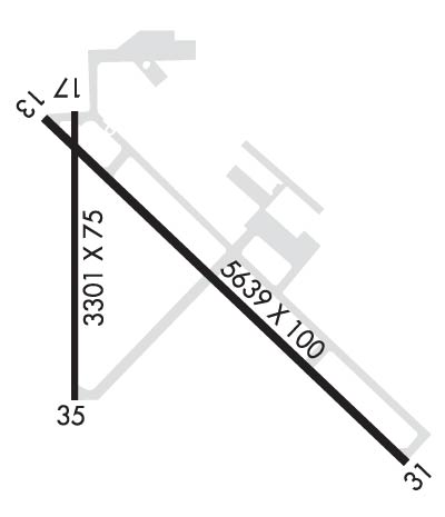
Runway Identifications
Runway Identification: 13/31Length: 5639 ft
Width: 100 ft
Surface: ASPHALT-GOOD CONDITION
Edge lights: Medium IntensityTreatment: NONE
| | Runway: 13 | | Runway: 31 |
| Mag heading: | 128° | Mag heading: | 308° |
| Rwy Slope: | -.11% Down | Rwy Slope: | .11% Up |
| Approach: | | Approach: | ILS |
| Pattern: | Left Traffic | Pattern: | Left Traffic |
| Markings: | PRECISION INSTRUMENT | Markings: | PRECISION INSTRUMENT |
| Marking Condition: | GOOD | Marking Condition: | GOOD |
| Arresting Dev: | | Arresting Dev: | |
| Lat & Long: | N4617.4 W09609.7 | Lat. & Long.: | N4616.7 W09608.8 |
| Elev: | 1181.8 ft. MSL | Elev: | 1175.6 ft. MSL |
| TCH: | 52 ft. AGL | TCH: | 52 ft. AGL |
| Visual Glide Path: | 3.00 degrees | Visual Glide Path: | 3.00 degrees |
| Displaced Threshold: | No | Displaced Threshold: | No |
| Touchdown Zone: | YES | Touchdown Zone: | YES |
| Touchdown Elev.: | 1182.2 feet | Touchdown Elev.: | 1182.0 feet |
| Visual Glide Slope: | 4-Light PAPI on LEFT side of Runway | Visual Glide Slope: | 4-Light PAPI on LEFT side of Runway |
| RVR Equipment: | | RVR Equipment: | |
| RVV Equipment: | NO | RVV Equipment: | NO |
| Approach Lights: | | Approach Lights: | MALSR - 1,400 foot medium intensity approach lighting system with runway alignment indicator lights |
| REIL: | YES | REIL: | NO |
| Centerline Lights: | NO | Centerline Lights: | NO |
| Touchdown lights: | NO | Touchdown lights: | NO |
| Runway Category: | D | Runway Category: | Precision Instrument Runway |
| Declared Distances: | | Declared Distances: | |
| Comments: | | Comments: | 8 FT HAY BALES, 140 FT DIST, 270 FT R. |
Runway Identification: 17/35Length: 3301 ft
Width: 75 ft
Surface: ASPHALT-FAIR CONDITION
Edge lights: Medium IntensityTreatment: NONE
| | Runway: 17 | | Runway: 35 |
| Mag heading: | 174° | Mag heading: | 354° |
| Rwy Slope: | -.75% Down | Rwy Slope: | .75% Up |
| Approach: | | Approach: | |
| Pattern: | Left Traffic | Pattern: | Left Traffic |
| Markings: | NONPRECISION INSTRUMENT | Markings: | NONPRECISION INSTRUMENT |
| Marking Condition: | GOOD | Marking Condition: | GOOD |
| Arresting Dev: | | Arresting Dev: | |
| Lat & Long: | N4617.4 W09609.7 | Lat. & Long.: | N4616.8 W09609.7 |
| Elev: | 1182.3 ft. MSL | Elev: | 1157.4 ft. MSL |
| TCH: | | TCH: | |
| Visual Glide Path: | | Visual Glide Path: | |
| Displaced Threshold: | No | Displaced Threshold: | No |
| Touchdown Zone: | YES | Touchdown Zone: | YES |
| Touchdown Elev.: | 1182.6 feet | Touchdown Elev.: | 1181.5 feet |
| Visual Glide Slope: | | Visual Glide Slope: | |
| RVR Equipment: | | RVR Equipment: | |
| RVV Equipment: | NO | RVV Equipment: | NO |
| Approach Lights: | | Approach Lights: | |
| REIL: | NO | REIL: | YES |
| Centerline Lights: | NO | Centerline Lights: | NO |
| Touchdown lights: | NO | Touchdown lights: | NO |
| Runway Category: | Runway with a Visual Approach | Runway Category: | Runway with a Non-precision Approach having visibility minimums greater than 3/4 mile |
| Declared Distances: | | Declared Distances: | |
| Comments: | | Comments: | 3 FT BRUSH, 13 FT DIST, 166 FT L. |

