Current Weather/Notams (Metars, TAFs, Notams, NWS Forecast, PIREPS, and nearby weather)
Customs Information Send updates to Support@FltPlan.com
Customs Not Available
Database effective 04/18/2024
Airport Diagram might not be current.
|
| Facility Name: | FINDLAY |
| City Name: | FINDLAY |
| County: | HANCOCK |
| State abbrev: | OH |
| State Name: | OHIO |
| | |
| Ownership: | PUBLICLY OWNED |
| Use: | OPEN TO THE PUBLIC |
| Owner's Name: | CITY OF FINDLAY |
| Address: | 310 MUNICIPAL BLDG |
| | FINDLAY, OH 45840-3346 |
| Owner's Phone: | 419-424-7137 |
| | |
| Manager's Name: | AMANDA MCGEE; AIRPORT@FINDLAYOHIO.COM. |
| Address: | 1615 GRAY ST |
| | FINDLAY, OH 45840-1411 |
| Phone: | 419-422-4182 |
| | |
| FAA Region: | GREAT LAKES |
| FAA Field Office: | DET |
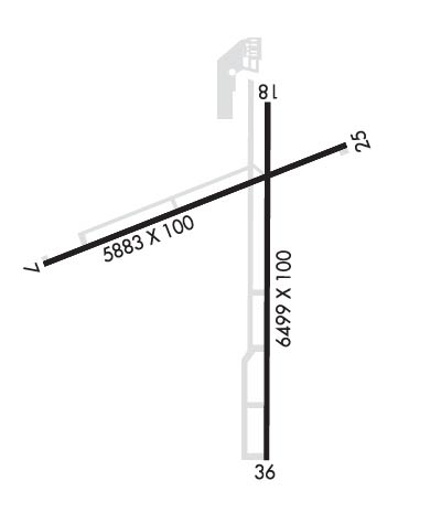
Runway Identifications
Runway Identification: 07/25Length: 5883 ft
Width: 100 ft
Surface: ASPHALT-GOOD CONDITION
Edge lights: High IntensityTreatment: NONE
| | Runway: 07 | | Runway: 25 |
| Mag heading: | 74° | Mag heading: | 254° |
| Rwy Slope: | .21% Up | Rwy Slope: | -.21% Down |
| Approach: | | Approach: | |
| Pattern: | Left Traffic | Pattern: | Left Traffic |
| Markings: | NONPRECISION INSTRUMENT | Markings: | NONPRECISION INSTRUMENT |
| Marking Condition: | GOOD | Marking Condition: | GOOD |
| Arresting Dev: | | Arresting Dev: | |
| Lat & Long: | N4100.7 W08340.9 | Lat. & Long.: | N4101.0 W08339.7 |
| Elev: | 793.7 ft. MSL | Elev: | 805.8 ft. MSL |
| TCH: | 24 ft. AGL | TCH: | 31 ft. AGL |
| Visual Glide Path: | 3.00 degrees | Visual Glide Path: | 3.00 degrees |
| Displaced Threshold: | 324 feet | Displaced Threshold: | 999 feet |
| Touchdown Zone: | YES | Touchdown Zone: | YES |
| Touchdown Elev.: | 809.5 feet | Touchdown Elev.: | 812.4 feet |
| Visual Glide Slope: | 4-Light PAPI on LEFT side of Runway | Visual Glide Slope: | 4-Light PAPI on LEFT side of Runway |
| RVR Equipment: | | RVR Equipment: | |
| RVV Equipment: | NO | RVV Equipment: | NO |
| Approach Lights: | | Approach Lights: | |
| REIL: | YES | REIL: | YES |
| Centerline Lights: | NO | Centerline Lights: | NO |
| Touchdown lights: | NO | Touchdown lights: | NO |
| Runway Category: | Runway with a Non-precision Approach having visibility minimums greater than 3/4 mile | Runway Category: | Runway with a Non-precision Approach having visibility minimums greater than 3/4 mile |
| Declared Distances: | TORA:5251' TODA:5251' ASDA:4881' LDA:4558' | Declared Distances: | TORA:5786' TODA:5786' ASDA:5558' LDA:4558' |
| Obstructions: | TREES | Obstructions: | ROAD |
| Marked: | NOT Marked/Lighted | Marked: | NOT Marked/Lighted |
| Clearance slope: | 28:1; APCH SLP 15:1 TO DTHR OVR 70 FT TREES, 1100 FT DIST, 415 FT L. | Clearance slope: | |
| Obstruction height: | 70 feet AGL | Obstruction height: | 21 feet AGL |
| Dist. from runway: | 2200 feet | Dist. from runway: | 201 feet |
| Centerline offset: | 270 left of centerline | Centerline offset: | 250 feet right of centerline |
| Comments: | | Comments: | 12 FT L/M BLAST FENCE, 117 FT DIST; 18 FT ROAD, 110 FT DIST. |
Runway Identification: 18/36Length: 6499 ft
Width: 100 ft
Surface: ASPHALT-GOOD CONDITION
Edge lights: High IntensityTreatment: NONE
| | Runway: 18 | | Runway: 36 |
| Mag heading: | 185° | Mag heading: | 5° |
| Rwy Slope: | -.02% Down | Rwy Slope: | .02% Up |
| Approach: | | Approach: | |
| Pattern: | Left Traffic | Pattern: | Left Traffic |
| Markings: | NONPRECISION INSTRUMENT | Markings: | NONPRECISION INSTRUMENT |
| Marking Condition: | GOOD | Marking Condition: | GOOD |
| Arresting Dev: | | Arresting Dev: | |
| Lat & Long: | N4101.1 W08340.0 | Lat. & Long.: | N4100.1 W08340.0 |
| Elev: | 804.5 ft. MSL | Elev: | 803.2 ft. MSL |
| TCH: | 43 ft. AGL | TCH: | 50 ft. AGL |
| Visual Glide Path: | 3.00 degrees | Visual Glide Path: | 3.00 degrees |
| Displaced Threshold: | No | Displaced Threshold: | No |
| Touchdown Zone: | YES | Touchdown Zone: | YES |
| Touchdown Elev.: | 812.8 feet | Touchdown Elev.: | 808.5 feet |
| Visual Glide Slope: | 4-Light PAPI on LEFT side of Runway | Visual Glide Slope: | 4-Light PAPI on LEFT side of Runway |
| RVR Equipment: | | RVR Equipment: | |
| RVV Equipment: | NO | RVV Equipment: | NO |
| Approach Lights: | | Approach Lights: | |
| REIL: | NO | REIL: | YES |
| Centerline Lights: | NO | Centerline Lights: | NO |
| Touchdown lights: | NO | Touchdown lights: | NO |
| Runway Category: | Runway with a Non-precision Approach having visibility minimums greater than 3/4 mile | Runway Category: | Runway with a Non-precision Approach having visibility minimums greater than 3/4 mile |
| Declared Distances: | | Declared Distances: | |
| Obstructions: | PLINE | Obstructions: | TREES |
| Marked: | NOT Marked/Lighted | Marked: | NOT Marked/Lighted |
| Clearance slope: | 31:1; APCH RATIO 33:1 TO DTHR. | Clearance slope: | 31:1 |
| Obstruction height: | 60 feet AGL | Obstruction height: | 80 feet AGL |
| Dist. from runway: | 2100 feet | Dist. from runway: | 2650 feet |
| Centerline offset: | 540 right of centerline | Centerline offset: | |
| Comments: | | Comments: | |

