Current Weather/Notams (Metars, TAFs, Notams, NWS Forecast, PIREPS, and nearby weather)
Customs Information Send updates to Support@FltPlan.com
Customs Not Available
Database effective 05/16/2024
Airport Diagram might not be current.
|
| Facility Name: | FREDERICK RGNL |
| City Name: | FREDERICK |
| County: | TILLMAN |
| State abbrev: | OK |
| State Name: | OKLAHOMA |
| | |
| Ownership: | PUBLICLY OWNED |
| Use: | OPEN TO THE PUBLIC |
| Owner's Name: | CITY OF FREDERICK |
| Address: | CITY HALL PO BOX 399 |
| | FREDERICK, OK 73542 |
| Owner's Phone: | 580-335-7551 |
| | |
| Manager's Name: | DONNIE COLEMAN |
| Address: | CITY HALL PO BOX 399 |
| | FREDERICK, OK 73542 |
| Phone: | 580-335-2421 |
| | |
| FAA Region: | SOUTHWEST |
| FAA Field Office: | AOK |
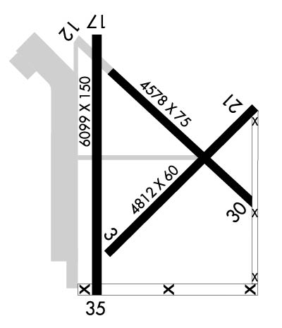
Runway Identifications
Runway Identification: 03/21Length: 4812 ft
Width: 60 ft
Surface: CONCRETE-POOR CONDITION
Edge lights: Treatment: NONE
| | Runway: 03 | | Runway: 21 |
| Mag heading: | 38° | Mag heading: | 218° |
| Rwy Slope: | .29% Up | Rwy Slope: | -.29% Down |
| Approach: | | Approach: | |
| Pattern: | Left Traffic | Pattern: | Left Traffic |
| Markings: | BASIC | Markings: | BASIC |
| Marking Condition: | FAIR | Marking Condition: | FAIR |
| Arresting Dev: | | Arresting Dev: | |
| Lat & Long: | N3420.8 W09859.3 | Lat. & Long.: | N3421.3 W09858.6 |
| Elev: | 1239.2 ft. MSL | Elev: | 1253.0 ft. MSL |
| TCH: | | TCH: | |
| Visual Glide Path: | | Visual Glide Path: | |
| Displaced Threshold: | No | Displaced Threshold: | No |
| Touchdown Zone: | YES | Touchdown Zone: | YES |
| Touchdown Elev.: | 1248.3 feet | Touchdown Elev.: | 1253.0 feet |
| Visual Glide Slope: | | Visual Glide Slope: | |
| RVR Equipment: | | RVR Equipment: | |
| RVV Equipment: | NO | RVV Equipment: | NO |
| Approach Lights: | | Approach Lights: | |
| REIL: | NO | REIL: | NO |
| Centerline Lights: | NO | Centerline Lights: | NO |
| Touchdown lights: | NO | Touchdown lights: | NO |
| Runway Category: | Runway with a Visual Approach | Runway Category: | Runway with a Visual Approach |
| Declared Distances: | | Declared Distances: | |
| Obstructions: | | Obstructions: | ROAD |
| Marked: | | Marked: | NOT Marked/Lighted |
| Clearance slope: | 20:1 | Clearance slope: | 10:1 |
| Obstruction height: | | Obstruction height: | 15 feet AGL |
| Dist. from runway: | | Dist. from runway: | 350 feet |
| Centerline offset: | | Centerline offset: | 250 feet left of centerline |
| Comments: | | Comments: | |
Runway Identification: 12/30Length: 4578 ft
Width: 75 ft
Surface: CONCRETE-POOR CONDITION
Edge lights: Treatment: NONE
| | Runway: 12 | | Runway: 30 |
| Mag heading: | 128° | Mag heading: | 308° |
| Rwy Slope: | -.27% Down | Rwy Slope: | .27% Up |
| Approach: | | Approach: | |
| Pattern: | Left Traffic | Pattern: | Left Traffic |
| Markings: | BASIC | Markings: | BASIC |
| Marking Condition: | FAIR | Marking Condition: | FAIR |
| Arresting Dev: | | Arresting Dev: | |
| Lat & Long: | N3421.5 W09859.3 | Lat. & Long.: | N3421.0 W09858.6 |
| Elev: | 1255.9 ft. MSL | Elev: | 1243.5 ft. MSL |
| TCH: | | TCH: | |
| Visual Glide Path: | | Visual Glide Path: | |
| Displaced Threshold: | No | Displaced Threshold: | No |
| Touchdown Zone: | YES | Touchdown Zone: | YES |
| Touchdown Elev.: | 1258.0 feet | Touchdown Elev.: | 1255.3 feet |
| Visual Glide Slope: | | Visual Glide Slope: | |
| RVR Equipment: | | RVR Equipment: | |
| RVV Equipment: | NO | RVV Equipment: | NO |
| Approach Lights: | | Approach Lights: | |
| REIL: | NO | REIL: | NO |
| Centerline Lights: | NO | Centerline Lights: | NO |
| Touchdown lights: | NO | Touchdown lights: | NO |
| Runway Category: | Runway with a Visual Approach | Runway Category: | Runway with a Visual Approach |
| Declared Distances: | | Declared Distances: | |
| Obstructions: | | Obstructions: | ROAD |
| Marked: | | Marked: | NOT Marked/Lighted |
| Clearance slope: | 20:1 | Clearance slope: | 11:1 |
| Obstruction height: | | Obstruction height: | 13 feet AGL |
| Dist. from runway: | | Dist. from runway: | 350 feet |
| Centerline offset: | | Centerline offset: | 250 feet right of centerline |
| Comments: | | Comments: | |
Runway Identification: 17/35Length: 6099 ft
Width: 150 ft
Surface: ASPHALT-GOOD CONDITION
Edge lights: Medium IntensityTreatment: NONE
| | Runway: 17 | | Runway: 35 |
| Mag heading: | 173° | Mag heading: | 353° |
| Rwy Slope: | -.30% Down | Rwy Slope: | .30% Up |
| Approach: | | Approach: | |
| Pattern: | Left Traffic | Pattern: | Left Traffic |
| Markings: | NONPRECISION INSTRUMENT | Markings: | NONPRECISION INSTRUMENT |
| Marking Condition: | GOOD | Marking Condition: | GOOD |
| Arresting Dev: | | Arresting Dev: | |
| Lat & Long: | N3421.6 W09859.4 | Lat. & Long.: | N3420.6 W09859.4 |
| Elev: | 1254.3 ft. MSL | Elev: | 1236.1 ft. MSL |
| TCH: | 50 ft. AGL | TCH: | 46 ft. AGL |
| Visual Glide Path: | 3.09 degrees | Visual Glide Path: | 3.09 degrees |
| Displaced Threshold: | No | Displaced Threshold: | No |
| Touchdown Zone: | YES | Touchdown Zone: | YES |
| Touchdown Elev.: | 1254.3 feet | Touchdown Elev.: | 1237.9 feet |
| Visual Glide Slope: | 4-Light PAPI on LEFT side of Runway | Visual Glide Slope: | 4-Light PAPI on LEFT side of Runway |
| RVR Equipment: | | RVR Equipment: | |
| RVV Equipment: | NO | RVV Equipment: | NO |
| Approach Lights: | | Approach Lights: | |
| REIL: | NO | REIL: | NO |
| Centerline Lights: | NO | Centerline Lights: | NO |
| Touchdown lights: | NO | Touchdown lights: | NO |
| Runway Category: | Runway with a Visual Approach | Runway Category: | D |
| Declared Distances: | | Declared Distances: | |

