
| ||||||||||||||||||||||||||||||||
| ||||||||||||||||||||||||||||||||
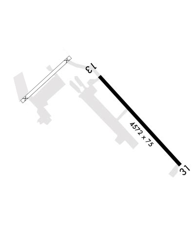
| Rwy | Rwy | |||||||
| 4500x75 | 4500' | 4500x75 | 4500' | 111.75 - 317° | ||||
| Runway ID | Single Wheel | Double Wheel | Double Tandem Wheel | Dual Double Wheel |
| 13/31 | N/A | N/A | N/A | N/A |
| H1 | N/A | N/A | N/A | N/A |
| These numbers are Advisory and are not limits. The Airport Manager should have more accurate Weight Limits | ||||
 Airport Diagram might not be current. | |
| Facility Name: | BUTTS AAF (FORT CARSON) |
| City Name: | FORT CARSON |
| County: | EL PASO |
| State abbrev: | CO |
| State Name: | COLORADO |
| Ownership: | ARMY OWNED |
| Use: | PRIVATE |
| Owner's Name: | US ARMY AERONAUTICAL SVCS AGENCY |
| Address: | |
| FT BELVOIR, VA 22060 | |
| Owner's Phone: | 520-228-6598/99 |
| Manager's Name: | |
| Address: | |
| Phone: | 719-526-2017 |
| FAA Region: | NORTHWEST MOUNTAIN |
| FAA Field Office: | DEN |
| Date | Sunrise | Sunset |
|---|---|---|
| 04/18/24 Thursday | 6:17 | 19:40 |
| 04/19/24 Friday | 6:16 | 19:41 |
| 04/20/24 Saturday | 6:15 | 19:41 |
| 04/21/24 Sunday | 6:13 | 19:42 |
| 04/22/24 Monday | 6:12 | 19:43 |
| 04/23/24 Tuesday | 6:11 | 19:44 |
| 04/24/24 Wednesday | 6:09 | 19:45 |
| 04/25/24 Thursday | 6:08 | 19:46 |
| 04/26/24 Friday | 6:07 | 19:47 |
| 04/27/24 Saturday | 6:06 | 19:48 |
| 04/28/24 Sunday | 6:04 | 19:49 |
| 04/29/24 Monday | 6:03 | 19:50 |
| 04/30/24 Tuesday | 6:02 | 19:51 |
| 05/01/24 Wednesday | 6:01 | 19:52 |
| Airport Attendance Schedule | CONTINUOUS; FLT FLW- BUTTS RDO OPR 1200-1200++ MONDAY-THURSDAY, 1200-0400++FRIDAY- SUNDAY EXC NEW YEARS, THANKSGIVING AND CHRISTMAS DAY. |
| Airport Status | OPERATIONAL (This Status can change at any time - please check NOTAMS) |
| Airport Lighting Schedule | SS-SR |
| Airport Storage Available | NONE |
| Extra Services Available | NONE |
| Wind Indicator | NONE |
| Control Tower | YES |
| CTAF Frequency | |
| Unicom Frequency | |
| Rotating Beacon Color | SWG |
| Segmented Circle | NO |
| Landing Fee |
| Airport Inspected | No Inspection Data Available performed by the OWNER |
| Inspection Date | Unknown |
| Type of Fuel Available | None |
| Airframe Repair Service | None |
| Power Plant Repair Service | None |
| Latitude | N3840.8 |
| Longitude | W10445.7 (ESTIMATED) |
| Arpt Elevation | 5874ft (SURVEYED) |
| Magnetic Variation | 08E |
| 3 miles S | of FORT CARSON |
| Traffic Pattern Altitude | TPA MULTI ENG F/W NSTD TFC RWY 13/31 E TFC 7400 FT; ALL OTHERS R/W 6400 FT, F/W 6900 FT. |
| Sectional Chart | DENVER |
| Operations (Reported) | Yearly | Avg. Daily |
|---|---|---|
| General Aviation Transient | 0 | 0 |
| General Aviation Local | 0 | 0 |
| Air Taxi | 0 | 0 |
| Commerical | 0 | 0 |
| Commuter | 0 | 0 |
| Military | 0 | 0 |
| Aircraft based on Field | |
|---|---|
| General Aviation Singles | 0 |
| General Aviation Multi | 0 |
| Jet Aircraft | 0 |
| General Aviation Helicopters | 0 |
| Military Aircraft | 0 |
| Gliders | 0 |
| Ultralights | 0 |
| FSS on field | NO |
| FSS tie-in | DENVER |
| FSS Phone | 1-800-WX-BRIEF |
| Who issues Notams | FCS |
| Notam D service at airport | YES |
| ARTCC Name | DENVER |
| Airport Certification | |
| Aircraft Rescue & Firefighting Index | None |
| Airport of Entry | No |
| Custom Landing Rights | No |
| Joint Civil/Military | No |
| Military Landing rights | No |
| SVC: NO FUEL AVBL. |
| WX TECHNICIAN (DSN 691-3620/3651, C719-526-3620/3651), AVBL 24H MON-SUN INCL HOL. BUTTS METRO AVBL ON FREQ 50.75. |
| UNITS TMPRLY ASGND ARE RQRD TO COORD WX SUPPORT IAW AFMAN 15-129. AUGMENTED WX OBSN VIEW RSTD FROM 180-270 DEG AND 310-340 DEG BY FLT LINE FAC AND BLDGS. |
| RSTD: 24 HR PPR FOR ALL ACFT. CTC BASE OPS DSN 691-3935, C719-526-3935. |
| 500 FT OVRN ON NW EOR, ACTF MAY TAX IN THIS AREA, UNUSE TO F/W ACFT FOR TKOF/LDG/ROLLOUT. |
| RWY 13/31 NSTD MARKINGS AND LIGHTING, TWY ALL NSTD MARKINGS AND LIGHTING, TWY B VFR OPS ONLY SR TO SS, NVD OPS ONLY SS TO SR. |
| WHEN BUTTS RDO IS CLSD CTC RANGE CTL 38.90 FOR OPS IN R2601. AVN TRNG AREA (ATA) AIR TO AIR FREQ ASSIGNMENT. ACFT OPERATING IN ATA 1-3 WILL MNT FM 37.200. ACFT OPERATING IN ATA 4-7 WILL MNT FM 68.750. ALL ACFT WILL MNT THE APPROPRIATE TRNG AREA FREQ WHEN OPERATING WITHIN R2601. WHEN OPERATING MULTI-SHIP ONLY ONE ACFT IS REQD TO MNT THE TRNG AREA FREQ. TRNG AREA FREQ ARE FOR TFC ADVSY AND DECONFLICTION AND WILL NOT BE USED FOR TACTICAL INTERNAL TFC. |
| ALL ACFT MUST REMAIN 100FT AGL OVER CONSTRUCTION AREAS. |
| ATC OPR MON-SAT 1300-0900Z++ CLSD WKND AND HOL. A - BASE OPS 1300-0500Z++ MON-FRI EXC HOL. |
| COMM: FLT FLW - CARSON RDO OPR MON-SAT 1200-0800Z++ CLSD WKNDS AND HOL. |
| D1 SOD PERMANENTLY CLSD. |
| MISC: NO TSNT ACFT SVC. |
| CAUTION: EXTV ARTILLERY AND SMALL ARMS FRNG. DUR PERIODS OF STRONG SW SFC WIND EXP STRUCTURE AND TRRN GENERATED TURB WITH WINDSHEAR NEAR THE APCH END RWY 13. |
Airport Communications & Frequencies:
| |||||||||||||||||||||||||||||||||
| Runway: 13 | Runway: 31 | ||
| Mag heading: | 129° | Mag heading: | 309° |
| Rwy Slope: | -1.00% Down | Rwy Slope: | 1.00% Up |
| Approach: | Approach: | ILS/DME | |
| Pattern: | Left Traffic | Pattern: | Left Traffic |
| Markings: | Markings: | ||
| Marking Condition: | FAIR | Marking Condition: | FAIR |
| Arresting Dev: | Arresting Dev: | ||
| Lat & Long: | N3841.0 W10445.7 | Lat. & Long.: | N3840.4 W10445.1 |
| Elev: | 5840.9 ft. MSL | Elev: | 5795.9 ft. MSL |
| TCH: | 40 ft. AGL | TCH: | 40 ft. AGL |
| Visual Glide Path: | 3.00 degrees | Visual Glide Path: | 3.00 degrees |
| Displaced Threshold: | No | Displaced Threshold: | No |
| Touchdown Zone: | YES | Touchdown Zone: | YES |
| Touchdown Elev.: | 5840.9 feet | Touchdown Elev.: | 5825.9 feet |
| Visual Glide Slope: | 4-Light PAPI on LEFT side of Runway | Visual Glide Slope: | 4-Light PAPI on LEFT side of Runway; PAPI UNUSBL BYD 7 DEGS RIGHT OF CNTRLN. |
| RVR Equipment: | RVR Equipment: | ||
| RVV Equipment: | NO | RVV Equipment: | NO |
| Approach Lights: | Approach Lights: | ||
| REIL: | NO | REIL: | NO |
| Centerline Lights: | NO | Centerline Lights: | NO |
| Touchdown lights: | NO | Touchdown lights: | NO |
| Runway Category: | Runway Category: | ||
| Declared Distances: | Declared Distances: |
