Current Weather/Notams (Metars, TAFs, Notams, NWS Forecast, PIREPS, and nearby weather)
Customs Information Send updates to Support@FltPlan.com
Customs Not Available
Database effective 05/16/2024
Airport Diagram might not be current.
|
| Facility Name: | FORT BRIDGER |
| City Name: | FORT BRIDGER |
| County: | UINTA |
| State abbrev: | WY |
| State Name: | WYOMING |
| | |
| Ownership: | PUBLICLY OWNED |
| Use: | OPEN TO THE PUBLIC |
| Owner's Name: | UINTA COUNTY |
| Address: | P O BOX 810 |
| | EVANSTON, WY 82931 |
| Owner's Phone: | 307-783-0415 |
| | |
| Manager's Name: | JEFF BREININGER |
| Address: | 225 9TH STREET |
| | EVANSTON, WY 82930 |
| Phone: | 307-783-0507 |
| | |
| FAA Region: | NORTHWEST MOUNTAIN |
| FAA Field Office: | DEN |
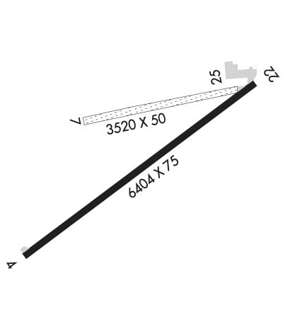
Runway Identifications
Runway Identification: 04/22Length: 6404 ft
Width: 75 ft
Surface: ASPHALT-FAIR CONDITION
Edge lights: Medium IntensityTreatment: NONE
| | Runway: 04 | | Runway: 22 |
| Mag heading: | 43° | Mag heading: | 223° |
| Rwy Slope: | -.48% Down | Rwy Slope: | .48% Up |
| Approach: | | Approach: | |
| Pattern: | Left Traffic | Pattern: | Left Traffic |
| Markings: | NONPRECISION INSTRUMENT | Markings: | NONPRECISION INSTRUMENT |
| Marking Condition: | GOOD | Marking Condition: | GOOD |
| Arresting Dev: | | Arresting Dev: | |
| Lat & Long: | N4123.2 W11025.0 | Lat. & Long.: | N4123.8 W11023.8 |
| Elev: | 7038.0 ft. MSL | Elev: | 7007.5 ft. MSL |
| TCH: | 40 ft. AGL | TCH: | 40 ft. AGL |
| Visual Glide Path: | 3.00 degrees | Visual Glide Path: | 3.00 degrees |
| Displaced Threshold: | No | Displaced Threshold: | No |
| Touchdown Zone: | YES | Touchdown Zone: | YES |
| Touchdown Elev.: | 7038.0 feet | Touchdown Elev.: | 7022.6 feet |
| Visual Glide Slope: | 2-Light PAPI on LEFT side of Runway | Visual Glide Slope: | 2-Light PAPI on LEFT side of Runway |
| RVR Equipment: | | RVR Equipment: | |
| RVV Equipment: | NO | RVV Equipment: | NO |
| Approach Lights: | | Approach Lights: | |
| REIL: | YES | REIL: | YES |
| Centerline Lights: | NO | Centerline Lights: | NO |
| Touchdown lights: | NO | Touchdown lights: | NO |
| Runway Category: | Runway with a Visual Approach | Runway Category: | Runway with a Non-precision Approach having visibility minimums greater than 3/4 mile |
| Declared Distances: | | Declared Distances: | |
Runway Identification: 07/25Length: 3520 ft
Width: 50 ft
Surface: GRASS NATURAL SOIL-FAIR CONDITION
Edge lights: Treatment: NONE
| | Runway: 07 | | Runway: 25 |
| Mag heading: | 68° | Mag heading: | 248° |
| Rwy Slope: | -.31% Down | Rwy Slope: | .31% Up |
| Approach: | | Approach: | |
| Pattern: | Left Traffic | Pattern: | Left Traffic |
| Markings: | NONE | Markings: | NONE |
| Marking Condition: | FAIR | Marking Condition: | FAIR |
| Arresting Dev: | | Arresting Dev: | |
| Lat & Long: | N4123.7 W11024.6 | Lat. & Long.: | N4123.8 W11023.9 |
| Elev: | 7019.7 ft. MSL | Elev: | 7008.9 ft. MSL |
| TCH: | | TCH: | |
| Visual Glide Path: | | Visual Glide Path: | |
| Displaced Threshold: | No | Displaced Threshold: | No |
| Touchdown Zone: | YES | Touchdown Zone: | YES |
| Touchdown Elev.: | 7019.7 feet | Touchdown Elev.: | 7017.4 feet |
| Visual Glide Slope: | | Visual Glide Slope: | |
| RVR Equipment: | | RVR Equipment: | |
| RVV Equipment: | NO | RVV Equipment: | NO |
| Approach Lights: | | Approach Lights: | |
| REIL: | NO | REIL: | NO |
| Centerline Lights: | NO | Centerline Lights: | NO |
| Touchdown lights: | NO | Touchdown lights: | NO |
| Runway Category: | Runway with a Visual Approach | Runway Category: | Runway with a Visual Approach |
| Declared Distances: | | Declared Distances: | |
| Obstructions: | FENCE | Obstructions: | |
| Marked: | NOT Marked/Lighted | Marked: | |
| Clearance slope: | 38:1 | Clearance slope: | 50:1 |
| Obstruction height: | 12 feet AGL | Obstruction height: | |
| Dist. from runway: | 450 feet | Dist. from runway: | |
| Centerline offset: | 62 right of centerline | Centerline offset: | |
| Comments: | | Comments: | |

