
| ||||||||||||||||||||||||||||||||||||||||||||
| ||||||||||||||||||||||||||||||||||||||||||||
| ||||||||||||||||||||||||||||||||||||||||||||
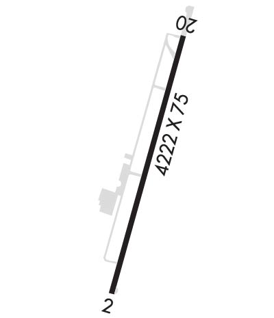
| Rwy | Rwy | |||||||
| 4323x75 | 4323' | 4323x75 | 4323' | |||||
| Runway ID | Single Wheel | Double Wheel | Double Tandem Wheel | Dual Double Wheel |
| 02/20 | 30,000 | N/A | N/A | N/A |
| These numbers are Advisory and are not limits. The Airport Manager should have more accurate Weight Limits | ||||
 Airport Diagram might not be current. | |
| Facility Name: | FARMINGTON RGNL |
| City Name: | FARMINGTON |
| County: | ST FRANCOIS |
| State abbrev: | MO |
| State Name: | MISSOURI |
| Ownership: | PUBLICLY OWNED |
| Use: | OPEN TO THE PUBLIC |
| Owner's Name: | CITY OF FARMINGTON |
| Address: | 110 W. COLUMBIA ST., LONG MEMORIAL BLDG. |
| FARMINGTON, MO 63640 | |
| Owner's Phone: | (314) 756-1701 |
| Manager's Name: | BRIAN HINSON |
| Address: | 110 W. COLUMBIA STREET, LONG MEMORIAL BUILDING |
| FARMINGTON, MO 63640 | |
| Phone: | 573-756-4502; EXT. 1601 |
| FAA Region: | CENTRAL |
| FAA Field Office: | NONE |
| Date | Sunrise | Sunset |
|---|---|---|
| 04/18/24 Thursday | 6:21 | 19:41 |
| 04/19/24 Friday | 6:20 | 19:42 |
| 04/20/24 Saturday | 6:19 | 19:43 |
| 04/21/24 Sunday | 6:17 | 19:44 |
| 04/22/24 Monday | 6:16 | 19:45 |
| 04/23/24 Tuesday | 6:15 | 19:46 |
| 04/24/24 Wednesday | 6:14 | 19:46 |
| 04/25/24 Thursday | 6:12 | 19:47 |
| 04/26/24 Friday | 6:11 | 19:48 |
| 04/27/24 Saturday | 6:10 | 19:49 |
| 04/28/24 Sunday | 6:09 | 19:50 |
| 04/29/24 Monday | 6:07 | 19:51 |
| 04/30/24 Tuesday | 6:06 | 19:52 |
| 05/01/24 Wednesday | 6:05 | 19:53 |
| Airport Attendance Schedule | 7 Days A Week 0730-1700 |
| Airport Status | OPERATIONAL (This Status can change at any time - please check NOTAMS) |
| Airport Lighting Schedule | ACTVT REIL RWY 02 & MIRL RWY 02/20 - CTAF. PAPI RWY 02 ON 24 HRS. |
| Airport Storage Available | Tie Downs |
| Extra Services Available | Air Freight, Charter, Aircraft Sales, Annual Surveying |
| Wind Indicator | YES - (lighted) |
| Control Tower | NO |
| CTAF Frequency | 122.800 |
| Unicom Frequency | 122.800 |
| Rotating Beacon Color | WG |
| Segmented Circle | YES |
| Landing Fee | NO |
| Airport Inspected | STATE - performed by STATE AERONAUTICAL PERSONNEL |
| Inspection Date | 04/27/2023 |
| Type of Fuel Available | Grade 100LL, JET A (freeze point -40C) |
| Airframe Repair Service | MAJOR |
| Power Plant Repair Service | MAJOR |
| Latitude | N3745.7 |
| Longitude | W09025.7 (ESTIMATED) |
| Arpt Elevation | 945ft (SURVEYED) |
| Magnetic Variation | 02W |
| 1 miles S | of FARMINGTON |
| Traffic Pattern Altitude | |
| Sectional Chart | ST LOUIS |
| Operations (Reported) | Yearly | Avg. Daily |
|---|---|---|
| General Aviation Transient | 5000 | 14 |
| General Aviation Local | 5750 | 16 |
| Air Taxi | 1000 | 3 |
| Commerical | 0 | 0 |
| Commuter | 0 | 0 |
| Military | 50 | 0 |
| Aircraft based on Field | |
|---|---|
| General Aviation Singles | 26 |
| General Aviation Multi | 4 |
| Jet Aircraft | 3 |
| General Aviation Helicopters | 2 |
| Military Aircraft | 0 |
| Gliders | 0 |
| Ultralights | 0 |
| FSS on field | NO |
| FSS tie-in | SAINT LOUIS |
| FSS Phone | 1-800-WX-BRIEF |
| Who issues Notams | FAM |
| Notam D service at airport | YES |
| ARTCC Name | KANSAS CITY |
| Airport Certification | |
| Aircraft Rescue & Firefighting Index | None |
| Airport of Entry | No |
| Custom Landing Rights | No |
| Joint Civil/Military | No |
| Military Landing rights | YES |
| NATIONAL PLAN OF INTEGRATED AIRPORT SYSTEMS (NPIAS) |
| GRANT AGREEMENTS UNDER FAAP/ADAP/AIP |
| ASSURANCES PURSUANT TO TITLE VI, CIVIL RIGHTS ACT OF 1964 |
| HEL ACTIVITY ON & INVOF AIRFIELD. |
| FOR CD IF UNA TO CTC ON FSS FREQ, CTC KANSAS CITY ARTCC AT 913-254-8508. |
| (OVERRUN LEN, RWY 02) 560 FT UNUSBL. |
| RWY 02/2 0 100 FT X 75 FT FULL STRENGTH CONC SAFETY AREA SOUTHWEST END; 590 FT BY 60 FT ASPH SAFETY AREA NORTHEAST END, NOT FULL STRENGTH. |
| RWY 02/2 0 FOR RWY ONLY; CONTACT AMGR FOR TWY STRENGTH. |
Airport Communications & Frequencies:
| |||||||||
| Runway: 02 | Runway: 20 | ||
| Mag heading: | 26° | Mag heading: | 206° |
| Rwy Slope: | .89% Up | Rwy Slope: | -.89% Down |
| Approach: | Approach: | ||
| Pattern: | Right Traffic | Pattern: | Left Traffic |
| Markings: | NONPRECISION INSTRUMENT | Markings: | NONPRECISION INSTRUMENT |
| Marking Condition: | GOOD | Marking Condition: | GOOD |
| Arresting Dev: | Arresting Dev: | ||
| Lat & Long: | N3745.3 W09025.9 | Lat. & Long.: | N3746.0 W09025.5 |
| Elev: | 907.2 ft. MSL | Elev: | 945.6 ft. MSL |
| TCH: | 42 ft. AGL | TCH: | 43 ft. AGL |
| Visual Glide Path: | 3.00 degrees | Visual Glide Path: | 4.00 degrees |
| Displaced Threshold: | No | Displaced Threshold: | No |
| Touchdown Zone: | YES | Touchdown Zone: | YES |
| Touchdown Elev.: | 926.1 feet | Touchdown Elev.: | 945.7 feet |
| Visual Glide Slope: | 4-Light PAPI on LEFT side of Runway | Visual Glide Slope: | 4-Light PAPI on LEFT side of Runway |
| RVR Equipment: | RVR Equipment: | ||
| RVV Equipment: | NO | RVV Equipment: | NO |
| Approach Lights: | Approach Lights: | ||
| REIL: | YES | REIL: | NO |
| Centerline Lights: | NO | Centerline Lights: | NO |
| Touchdown lights: | NO | Touchdown lights: | NO |
| Runway Category: | Runway with a Non-precision Approach having visibility minimums greater than 3/4 mile | Runway Category: | Runway with a Non-precision Approach having visibility minimums greater than 3/4 mile |
| Declared Distances: | Declared Distances: | ||
| Obstructions: | TREES | Obstructions: | |
| Marked: | NOT Marked/Lighted | Marked: | |
| Clearance slope: | 29:1; RWY 02 APCH SLOPE 40:1 TO DSPLCD THR. | Clearance slope: | 34:1 |
| Obstruction height: | 39 feet AGL | Obstruction height: | |
| Dist. from runway: | 1368 feet | Dist. from runway: | |
| Centerline offset: | 150 right of centerline | Centerline offset: | |
| Comments: | Comments: |