Click here for more info on on SMS!

KF87

UNION PARISH
FARMERVILLE
LA
Time Zone: Central
Lat: N 3243.5
Long: W 09220.2
Elev: 121
Var: -05
Longest Runway: 3003
CTAF: 122.9

FBO & Flight Services info for KF87

FBOs: Update your Fuel Prices

UNION PARISHPh: 318-243-4155
-
-
Service
Jet
100LL
SAF
MoGas
Full        Last Update: 04/10/2024 10:53

Self  5.13    
 Address: 152 AIRPORT DR   FARMERVILLE, LA 71241
If you are an FBO, call 1-203-262-1700 to update your info or email: FltPlan.Advertising@garmin.com
Advertise your FBO on FltPlan.com

Runway & Approach Info for KF87
Rwy
Length
Land Dist**
Approach*
  Rwy
Length
Land Dist**
Approach*
16
3003x75  3003'          
 
  
34
  3003x75  3003'          
 
 * only ILS, LOC, LDA, and SDF approaches to a specific runway are shown
** For any Declared Landing Distance Available, please see A/FD or Approach plates
Runway Weight Capability (lbs.) Help
Runway IDSingle WheelDouble WheelDouble Tandem WheelDual Double Wheel
16/348,000N/AN/AN/A
These numbers are Advisory and are not limits.   The Airport Manager should have more accurate Weight Limits
Approach Charts
FltPlan does not have IFR approach charts available for KF87.
Current Weather/Notams
Customs Information Send updates to Support@FltPlan.com
Customs Not Available
Database effective 05/16/2024
Airport Diagram of KF87
Airport Diagram might not be current.

Facility Name: UNION PARISH
City Name: FARMERVILLE
County: UNION
State abbrev: LA
State Name: LOUISIANA
   
Ownership: PUBLICLY OWNED
Use: OPEN TO THE PUBLIC
Owner's Name: UNION PARISH POLICE JURY
Address: PO BOX 723
 FARMERVILLE, LA 71241
Owner's Phone: 318-368-3296
  
Manager's Name: NICHOLAS GREEN; EMAIL: BEECHCRAFT32J@GMAIL.COM.
Address: 152 AIRPORT DRIVE
 FARMERVILLE, LA 71241
Phone: 318-243-4155
   
FAA Region: SOUTHWEST
FAA Field Office: LNM


Sunrise / Sunset times for UNION PARISH

DateSunriseSunset
04/25/24 Thursday6:2819:47
04/26/24 Friday6:2719:48
04/27/24 Saturday6:2619:49
04/28/24 Sunday6:2419:49
04/29/24 Monday6:2319:50
04/30/24 Tuesday6:2219:51
05/01/24 Wednesday6:2219:52
05/02/24 Thursday6:2119:52
05/03/24 Friday6:2019:53
05/04/24 Saturday6:1919:54
05/05/24 Sunday6:1819:55
05/06/24 Monday6:1719:55
05/07/24 Tuesday6:1619:56
05/08/24 Wednesday6:1519:57

Airport Facilities

Airport Attendance ScheduleUNATTENDED
Airport Status OPERATIONAL (This Status can change at any time - please check NOTAMS)
Airport Lighting ScheduleMIRL RY 16/34, REIL RYS 16 & 34 PRESET LOW INTST DUSK-DAWN; TO INCR INTST ACTVT - CTAF.
Airport Storage AvailableTie Downs
Extra Services AvailableNONE
Wind IndicatorYES - (lighted)
Control TowerNO
CTAF Frequency122.900
Unicom Frequency
Rotating Beacon ColorWG
Segmented CircleNO
Landing FeeNO

Airport Inspection Data

Airport InspectedSTATE - performed by STATE AERONAUTICAL PERSONNEL
Inspection Date11/14/2023

Airport Services

Type of Fuel AvailableGrade 100LL
Airframe Repair ServiceNONE
Power Plant Repair ServiceNONE

Geographic Data

LatitudeN3243.5
LongitudeW09220.2 (ESTIMATED)
Arpt Elevation121ft (SURVEYED)
Magnetic Variation05E
4 miles SEof FARMERVILLE
Traffic Pattern Altitude
Sectional ChartMEMPHIS

Aircraft Data

Operations (Reported)YearlyAvg. Daily
General Aviation Transient 350010
General Aviation Local 1200033
Air Taxi 00
Commerical 00
Commuter 00
Military 00
Aircraft based on Field
General Aviation Singles 26
General Aviation Multi 0
Jet Aircraft 0
General Aviation Helicopters 1
Military Aircraft 0
Gliders 0
Ultralights 0

FAA Services

FSS on field NO
FSS tie-in DE RIDDER
FSS Phone 1-800-WX-BRIEF
Who issues Notams DRI
Notam D service at airport YES
ARTCC Name FORT WORTH

Federal Status

Airport Certification
Aircraft Rescue & Firefighting IndexNone
Airport of EntryNo
Custom Landing RightsNo
Joint Civil/MilitaryNo
Military Landing rightsNo

Federal Agreements

NATIONAL PLAN OF INTEGRATED AIRPORT SYSTEMS (NPIAS)

Remarks

THIS AIRPORT HAS BEEN SURVEYED BY THE NATIONAL GEODETIC SURVEY.
OXIDATION POND WITH 6 FT FENCE 150 FT WEST OF CNTRLN ON THE NORTH END OF RY 16.
FOR CD CTC MONROE APCH AT 318-327-5641, IF UNAVBL, CTC FORT WORTH ARTCC AT 817-858-7584.
RWY 16/3 4 RY CLSD TO ACFT OVER 12,500 LBS.
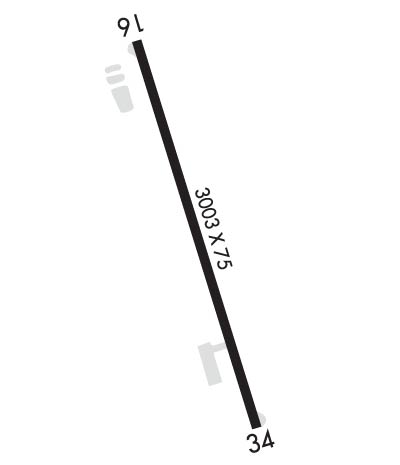
Runway Identifications
Runway Identification: 16/34
Length: 3003 ft
Width: 75 ft
Surface: ASPHALT-GOOD CONDITION
Edge lights: Medium Intensity

Treatment: NONE

 Runway: 16   Runway: 34
Mag heading: 158°Mag heading: 338°
Rwy Slope: .11% UpRwy Slope: -.11% Down
Approach: Approach:
Pattern: Left TrafficPattern: Left Traffic
Markings: NONPRECISION INSTRUMENTMarkings: NONPRECISION INSTRUMENT
Marking Condition: FAIRMarking Condition: FAIR
Arresting Dev: Arresting Dev:
Lat & Long: N3243.7  W09220.3Lat. & Long.: N3243.3  W09220.1
Elev: 117.8 ft. MSLElev: 121.0 ft. MSL
TCH: 63 ft. AGLTCH: 50 ft. AGL
Visual Glide Path: 3.83 degreesVisual Glide Path: 3.00 degrees
Displaced Threshold: NoDisplaced Threshold: No
Touchdown Zone: YESTouchdown Zone: YES
Touchdown Elev.: 121.0 feetTouchdown Elev.: 121.0 feet
Visual Glide Slope: 2-Light PAPI on LEFT side of RunwayVisual Glide Slope: 2-Light PAPI on LEFT side of Runway
RVR Equipment: RVR Equipment:
RVV Equipment: NORVV Equipment: NO
Approach Lights: Approach Lights:
REIL: YESREIL: YES
Centerline Lights: NOCenterline Lights: NO
Touchdown lights: NOTouchdown lights: NO
Runway Category: Runway with a Visual ApproachRunway Category: Runway with a Visual Approach
Declared Distances: Declared Distances:
Obstructions: TREESObstructions: TREES
Marked: NOT Marked/LightedMarked: NOT Marked/Lighted
Clearance slope: 3:1Clearance slope: 21:1
Obstruction height: 60 feet AGLObstruction height: 52 feet AGL
Dist. from runway: 412 feetDist. from runway: 1310 feet
Centerline offset: 259 right of centerlineCenterline offset: 182 feet left of centerline
Comments: Comments:
C:/P: