Click here for more info on on SMS!

KF75

HARRISON FIELD OF KNOX CITY
KNOX CITY
TX
Time Zone: Central
Lat: N 3326.3
Long: W 09948.8
Elev: 1500
Var: -08
Longest Runway: 3200
CTAF: 122.9

FBO & Flight Services info for KF75

FBOs: Update your Fuel Prices

AIRPORTPh: 940-658-3313
-
Freq: 122.9
Service
Jet
100LL
SAF
MoGas
Fuel Avail: NO FUEL AVAILABLE
Full        Last Update: 04/19/2024 00:01:46

Self        
If you are an FBO, call 1-203-262-1700 to update your info or email: FltPlan.Advertising@garmin.com
Advertise your FBO on FltPlan.com

Runway & Approach Info for KF75
Rwy
Length
Land Dist**
Approach*
  Rwy
Length
Land Dist**
Approach*
01
3200x50  3200'          
 
  
19
  3200x50  3200'          
 
 * only ILS, LOC, LDA, and SDF approaches to a specific runway are shown
** For any Declared Landing Distance Available, please see A/FD or Approach plates
Runway Weight Capability (lbs.) Help
Runway IDSingle WheelDouble WheelDouble Tandem WheelDual Double Wheel
01/1910,000N/AN/AN/A
These numbers are Advisory and are not limits.   The Airport Manager should have more accurate Weight Limits
Approach Charts
FltPlan does not have IFR approach charts available for KF75.
Current Weather/Notams
Customs Information Send updates to Support@FltPlan.com
Customs Not Available
Database effective 04/18/2024
Airport Diagram of KF75
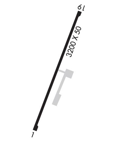
Airport Diagram might not be current.

Facility Name: HARRISON FLD OF KNOX CITY
City Name: KNOX CITY
County: KNOX
State abbrev: TX
State Name: TEXAS
   
Ownership: PUBLICLY OWNED
Use: OPEN TO THE PUBLIC
Owner's Name: CITY OF KNOX CITY
Address: 902 E. MAIN
 KNOX CITY, TX 79529
Owner's Phone: 940-658-3313
  
Manager's Name: SAM WATSON; CITY ADMINISTRATOR/AMGR.
Address: 902 E. MAIN
 KNOX CITY, TX 79529
Phone: 940-658-3313
   
FAA Region: SOUTHWEST
FAA Field Office: TEX


Sunrise / Sunset times for HARRISON FLD OF KNOX CITY

DateSunriseSunset
04/18/24 Thursday7:0420:13
04/19/24 Friday7:0320:14
04/20/24 Saturday7:0220:14
04/21/24 Sunday7:0120:15
04/22/24 Monday7:0020:16
04/23/24 Tuesday6:5920:17
04/24/24 Wednesday6:5820:17
04/25/24 Thursday6:5620:18
04/26/24 Friday6:5520:19
04/27/24 Saturday6:5420:20
04/28/24 Sunday6:5320:20
04/29/24 Monday6:5220:21
04/30/24 Tuesday6:5120:22
05/01/24 Wednesday6:5020:23

Airport Facilities

Airport Attendance ScheduleUNATTENDED
Airport Status OPERATIONAL (This Status can change at any time - please check NOTAMS)
Airport Lighting ScheduleMIRL RWY 01/19 PRESET LOW INTST DUSK-2300; TO INCR INTST OR AFT 2300 ACTVT - CTAF.
Airport Storage AvailableTie Downs
Extra Services AvailableCrop Dusting
Wind IndicatorYES - (lighted)
Control TowerNO
CTAF Frequency122.900
Unicom Frequency
Rotating Beacon ColorWG
Segmented CircleYES
Landing FeeNO

Airport Inspection Data

Airport InspectedSTATE - performed by PRIVATE CONTRACT PERSONNEL
Inspection Date11/18/2023

Airport Services

Type of Fuel AvailableNone
Airframe Repair ServiceNONE
Power Plant Repair ServiceNONE

Geographic Data

LatitudeN3326.3
LongitudeW09948.8 (ESTIMATED)
Arpt Elevation1500ft (ESTIMATED)
Magnetic Variation08E
1 miles Nof KNOX CITY
Traffic Pattern Altitude
Sectional ChartDALLAS-FT WORTH

Aircraft Data

Operations (Reported)YearlyAvg. Daily
General Aviation Transient 9002
General Aviation Local 18005
Air Taxi 00
Commerical 00
Commuter 00
Military 00
Aircraft based on Field
General Aviation Singles 3
General Aviation Multi 0
Jet Aircraft 0
General Aviation Helicopters 12
Military Aircraft 0
Gliders 0
Ultralights 0

FAA Services

FSS on field NO
FSS tie-in FORT WORTH
FSS Phone 1-800-WX-BRIEF
Who issues Notams FTW
Notam D service at airport YES
ARTCC Name FORT WORTH

Federal Status

Airport Certification
Aircraft Rescue & Firefighting IndexNone
Airport of EntryNo
Custom Landing RightsNo
Joint Civil/MilitaryNo
Military Landing rightsNo

Remarks

RWY 19, 20 FT PUMPJACK 125 FT RIGHT OF CNTRLN 40 FT SOUTH RWY 19 THR.
RWY 19 +20 FT TREES 105 FT RIGHT, 0-200 FT SOUTH OF RWY THR.
FOR CD CTC FORT WORTH ARTCC AT 817-858-7584.
Runway Identifications
Runway Identification: 01/19
Length: 3200 ft
Width: 50 ft
Surface: ASPHALT-GOOD CONDITION
Edge lights: Medium Intensity

Treatment: NONE

 Runway: 01   Runway: 19
Mag heading: N/AMag heading: N/A
Approach: Approach:
Pattern: Left TrafficPattern: Left Traffic
Markings: BASICMarkings: BASIC
Marking Condition: GOODMarking Condition: GOOD
Arresting Dev: Arresting Dev:
Lat & Long:   Lat. & Long.:   
Elev: N/AElev: N/A
TCH: TCH: 27 ft. AGL
Visual Glide Path: Visual Glide Path: 3.75 degrees
Displaced Threshold: NoDisplaced Threshold: No
Touchdown Zone: NOTouchdown Zone: NO
Touchdown Elev.: Touchdown Elev.:
Visual Glide Slope: Visual Glide Slope: 2-Light PAPI on LEFT side of Runway
RVR Equipment: RVR Equipment:
RVV Equipment: NORVV Equipment: NO
Approach Lights: Approach Lights:
REIL: NOREIL: NO
Centerline Lights: NOCenterline Lights: NO
Touchdown lights: NOTouchdown lights: NO
Runway Category: Runway with a Visual ApproachRunway Category: Runway with a Visual Approach
Declared Distances: Declared Distances:
Obstructions: TREEObstructions: TREES
Marked: NOT Marked/LightedMarked: NOT Marked/Lighted
Clearance slope: 13:1Clearance slope: 6:1
Obstruction height: 20 feet AGLObstruction height: 20 feet AGL
Dist. from runway: 475 feetDist. from runway: 334 feet
Centerline offset: 50 right of centerlineCenterline offset:
Comments: Comments: 4 FT FENCE 0 FT DSTC, 100 FT R; 20 FT TREES, 0-170 FT DSTC, 100 FT R.
C:1/P: