Click here for more info on on SMS!

KF53

FRANKLIN COUNTY
MOUNT VERNON
TX
Time Zone: Central
Lat: N 3312.9
Long: W 09514.2
Elev: 412
Var: -06
Longest Runway: 3900
CTAF: 123.0

FBO & Flight Services info for KF53

FBOs: Update your Fuel Prices

FRANKLIN CO ARPTPh: 903-767-0602 Fax: 903-856-7820 Freq: 123.0
Service
Jet
100LL
SAF
MoGas
Fuel Avail: ~~TEMPORARILY NO FUEL AVAILABLE.
Full        Last Update: 04/19/2024 00:01:46

Self        
 Address: AIRPORT RD   MOUNT VERNON, TX 75457
If you are an FBO, call 1-203-262-1700 to update your info or email: FltPlan.Advertising@garmin.com
Advertise your FBO on FltPlan.com

Runway & Approach Info for KF53
Rwy
Length
Land Dist**
Approach*
  Rwy
Length
Land Dist**
Approach*
13
3900x60  3900'          
 
  
31
  3900x60  3900'          
 
 * only ILS, LOC, LDA, and SDF approaches to a specific runway are shown
** For any Declared Landing Distance Available, please see A/FD or Approach plates
Runway Weight Capability (lbs.) Help
Runway IDSingle WheelDouble WheelDouble Tandem WheelDual Double Wheel
13/3112,500N/AN/AN/A
These numbers are Advisory and are not limits.   The Airport Manager should have more accurate Weight Limits
Approach Charts
Approaches    
Current Weather/Notams
Customs Information Send updates to Support@FltPlan.com
Customs Not Available
Database effective 04/18/2024
Airport Diagram of KF53
Airport Diagram might not be current.

Facility Name: FRANKLIN COUNTY
City Name: MOUNT VERNON
County: FRANKLIN
State abbrev: TX
State Name: TEXAS
   
Ownership: PUBLICLY OWNED
Use: OPEN TO THE PUBLIC
Owner's Name: FRANKLIN COUNTY
Address: 200 N. KAUFMAN
 MOUNT VERNON, TX 75457
Owner's Phone: 903-537-2342
  
Manager's Name: JOHN GANDY
Address: PO BOX 989
 MOUNT VERNON, TX 75457
Phone: (903) 588-2643
   
FAA Region: SOUTHWEST
FAA Field Office: TEX


Sunrise / Sunset times for FRANKLIN COUNTY

DateSunriseSunset
04/18/24 Thursday6:4619:54
04/19/24 Friday6:4519:55
04/20/24 Saturday6:4419:56
04/21/24 Sunday6:4319:57
04/22/24 Monday6:4219:57
04/23/24 Tuesday6:4119:58
04/24/24 Wednesday6:4019:59
04/25/24 Thursday6:3820:00
04/26/24 Friday6:3720:00
04/27/24 Saturday6:3620:01
04/28/24 Sunday6:3520:02
04/29/24 Monday6:3420:03
04/30/24 Tuesday6:3320:03
05/01/24 Wednesday6:3220:04

Airport Facilities

Airport Attendance ScheduleUNATND
Airport Status OPERATIONAL (This Status can change at any time - please check NOTAMS)
Airport Lighting ScheduleSS-SR
Airport Storage AvailableTie Downs
Extra Services AvailableNONE
Wind IndicatorYES - (lighted)
Control TowerNO
CTAF Frequency123.000
Unicom Frequency123.000
Rotating Beacon ColorWG
Segmented CircleYES
Landing Fee

Airport Inspection Data

Airport InspectedSTATE - performed by PRIVATE CONTRACT PERSONNEL
Inspection Date09/14/2022

Airport Services

Type of Fuel AvailableNone
Airframe Repair ServiceNone
Power Plant Repair ServiceNone

Geographic Data

LatitudeN3312.9
LongitudeW09514.2 (ESTIMATED)
Arpt Elevation412ft (SURVEYED)
Magnetic Variation06E
2 miles NWof MOUNT VERNON
Traffic Pattern Altitude
Sectional ChartDALLAS-FT WORTH

Aircraft Data

Operations (Reported)YearlyAvg. Daily
General Aviation Transient 18005
General Aviation Local 540015
Air Taxi 00
Commerical 00
Commuter 00
Military 00
Aircraft based on Field
General Aviation Singles 15
General Aviation Multi 0
Jet Aircraft 0
General Aviation Helicopters 1
Military Aircraft 0
Gliders 0
Ultralights 0

FAA Services

FSS on field NO
FSS tie-in FORT WORTH
FSS Phone 1-800-WX-BRIEF
Who issues Notams FTW
Notam D service at airport YES
ARTCC Name FORT WORTH

Federal Status

Airport Certification
Aircraft Rescue & Firefighting IndexNone
Airport of EntryNo
Custom Landing RightsNo
Joint Civil/MilitaryNo
Military Landing rightsNo

Federal Agreements

NATIONAL PLAN OF INTEGRATED AIRPORT SYSTEMS (NPIAS)
GRANT AGREEMENTS UNDER FAAP/ADAP/AIP
ASSURANCES PURSUANT TO TITLE VI, CIVIL RIGHTS ACT OF 1964

Remarks

FOR CD CTC FORT WORTH ARTCC AT 817-858-7584.
Airport Communications & Frequencies:
CTAF Frequency:
123.000
Unicom Frequency:
123.000
Remarks
  • APCH/DEP CTL SVC PRVDD BY FORT WORTH ARTCC (ZFW) ON FREQS 132.025/360.75 (CUMBY RCAG).
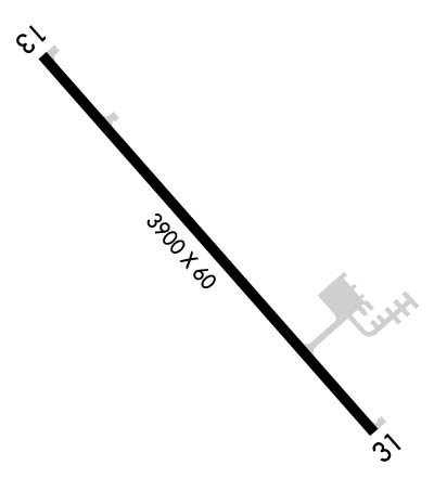
  • Runway Identifications
    Runway Identification: 13/31
    Length: 3900 ft
    Width: 60 ft
    Surface: ASPHALT
    Edge lights: Medium Intensity

    Treatment: NONE

     Runway: 13   Runway: 31
    Mag heading: 130°Mag heading: 310°
    Rwy Slope: .42% UpRwy Slope: -.42% Down
    Approach: Approach:
    Pattern: Left TrafficPattern: Left Traffic
    Markings: NONPRECISION INSTRUMENTMarkings: NONPRECISION INSTRUMENT
    Marking Condition: GOODMarking Condition: GOOD
    Arresting Dev: Arresting Dev:
    Lat & Long: N3313.2  W09514.5Lat. & Long.: N3312.7  W09514.0
    Elev: 395.9 ft. MSLElev: 412.1 ft. MSL
    TCH: 37 ft. AGLTCH: 38 ft. AGL
    Visual Glide Path: 3.00 degreesVisual Glide Path: 3.00 degrees
    Displaced Threshold: NoDisplaced Threshold: No
    Touchdown Zone: YESTouchdown Zone: YES
    Touchdown Elev.: 407.7 feetTouchdown Elev.: 412.1 feet
    Visual Glide Slope: 2-Light PAPI on LEFT side of RunwayVisual Glide Slope: 2-Light PAPI on LEFT side of Runway
    RVR Equipment: RVR Equipment:
    RVV Equipment: NORVV Equipment: NO
    Approach Lights: Approach Lights:
    REIL: NOREIL: NO
    Centerline Lights: NOCenterline Lights: NO
    Touchdown lights: NOTouchdown lights: NO
    Runway Category: Runway with a Non-precision ApproachRunway Category: Runway with a Non-precision Approach
    Declared Distances: Declared Distances:
    Obstructions: TREESObstructions: TREES
    Marked: NOT Marked/LightedMarked: NOT Marked/Lighted
    Clearance slope: 5:1Clearance slope: 30:1
    Obstruction height: 36 feet AGLObstruction height: 46 feet AGL
    Dist. from runway: 400 feetDist. from runway: 1587 feet
    Centerline offset: 250 right of centerlineCenterline offset: 100 feet right of centerline
    Comments: Comments:
    C:/P: