Current Weather/Notams (Metars, TAFs, Notams, NWS Forecast, PIREPS, and nearby weather)
Customs Information Send updates to Support@FltPlan.com
Customs Not Available
Database effective 05/16/2024
Airport Diagram might not be current.
|
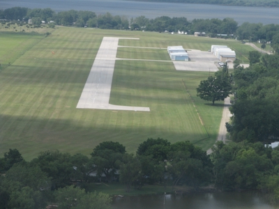
| Facility Name: | POSSUM KINGDOM |
| City Name: | GRAFORD |
| County: | PALO PINTO |
| State abbrev: | TX |
| State Name: | TEXAS |
| | |
| Ownership: | PUBLICLY OWNED |
| Use: | OPEN TO THE PUBLIC |
| Owner's Name: | BRAZOS RIVER AUTHORITY |
| Address: | 4400 COBBS DRIVE |
| | WACO, TX 76710 |
| Owner's Phone: | 254-776-1441 |
| | |
| Manager's Name: | TROY WEATHERHEAD |
| Address: | 301 OBSERVATION POINT ROAD |
| | GRAFORD, TX 76449 |
| Phone: | 940-779-2321 |
| | |
| FAA Region: | SOUTHWEST |
| FAA Field Office: | TEX |
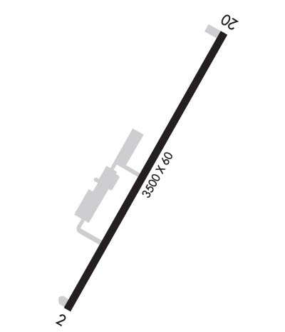
Runway Identifications
Runway Identification: 02/20Length: 3500 ft
Width: 60 ft
Surface: ASPHALT-FAIR CONDITION
Edge lights: Medium IntensityTreatment: NONE
| | Runway: 02 | | Runway: 20 |
| Mag heading: | 24° | Mag heading: | 204° |
| Rwy Slope: | .01% Up | Rwy Slope: | -.01% Down |
| Approach: | | Approach: | |
| Pattern: | Left Traffic | Pattern: | Left Traffic |
| Markings: | BASIC | Markings: | BASIC |
| Marking Condition: | FAIR | Marking Condition: | FAIR |
| Arresting Dev: | | Arresting Dev: | |
| Lat & Long: | N3255.2 W09826.4 | Lat. & Long.: | N3255.6 W09826.0 |
| Elev: | 1008.1 ft. MSL | Elev: | 1008.3 ft. MSL |
| TCH: | 33 ft. AGL | TCH: | 30 ft. AGL |
| Visual Glide Path: | 3.50 degrees | Visual Glide Path: | 3.50 degrees |
| Displaced Threshold: | No | Displaced Threshold: | No |
| Touchdown Zone: | YES | Touchdown Zone: | YES |
| Touchdown Elev.: | 1008.2 feet | Touchdown Elev.: | 1008.3 feet |
| Visual Glide Slope: | 2-Light PAPI on LEFT side of Runway | Visual Glide Slope: | 2-Light PAPI on LEFT side of Runway |
| RVR Equipment: | | RVR Equipment: | |
| RVV Equipment: | NO | RVV Equipment: | NO |
| Approach Lights: | | Approach Lights: | |
| REIL: | NO | REIL: | NO |
| Centerline Lights: | NO | Centerline Lights: | NO |
| Touchdown lights: | NO | Touchdown lights: | NO |
| Runway Category: | Runway with a Non-precision Approach | Runway Category: | Runway with a Non-precision Approach |
| Declared Distances: | | Declared Distances: | |
| Obstructions: | TREES | Obstructions: | TREES |
| Marked: | NOT Marked/Lighted | Marked: | NOT Marked/Lighted |
| Clearance slope: | ALSO 5 FT FENCE, 200 FT DSTC, 168 FT R. | Clearance slope: | |
| Obstruction height: | 5 feet AGL | Obstruction height: | 56 feet AGL |
| Dist. from runway: | 200 feet | Dist. from runway: | 200 feet |
| Centerline offset: | 217 left of centerline | Centerline offset: | 246 feet right of centerline |
| Comments: | 12 FT TREE, 0 FT DSTC, 250 FT R. | Comments: | 75 FT TREE 150 FT DSTC 234 FT R; 27 FT PLINE, 100 FT DSTC, 235 FT R. |