Click here for more info on on SMS!

KF34

FIREBAUGH
FIREBAUGH
CA
Time Zone: Pacific
Lat: N 3651.6
Long: W 12027.9
Elev: 157
Var: -16
Longest Runway: 3102
CTAF: 122.9

FBO & Flight Services info for KF34

FBOs: Update your Fuel Prices

AIRPORTPh: 209-659-2043
-
Freq: 122.9
Service
Jet
100LL
SAF
MoGas
Fuel Avail: NO FUEL AVAILABLE
Full        Last Update: 04/18/2024 05:44:54

Self        
If you are an FBO, call 1-203-262-1700 to update your info or email: FltPlan.Advertising@garmin.com
Advertise your FBO on FltPlan.com

Runway & Approach Info for KF34
Rwy
Length
Land Dist**
Approach*
  Rwy
Length
Land Dist**
Approach*
12
3102x60  3102'          
 
  
30
  3102x60  3102'          
 
 * only ILS, LOC, LDA, and SDF approaches to a specific runway are shown
** For any Declared Landing Distance Available, please see A/FD or Approach plates
Runway Weight Capability (lbs.) Help
Runway IDSingle WheelDouble WheelDouble Tandem WheelDual Double Wheel
12/3012,000N/AN/AN/A
These numbers are Advisory and are not limits.   The Airport Manager should have more accurate Weight Limits
Approach Charts
Approaches    
Current Weather/Notams
Customs Information Send updates to Support@FltPlan.com
Customs Not Available
Database effective 04/18/2024
Airport Diagram of KF34
Airport Diagram might not be current.

Facility Name: FIREBAUGH
City Name: FIREBAUGH
County: FRESNO
State abbrev: CA
State Name: CALIFORNIA
   
Ownership: PUBLICLY OWNED
Use: OPEN TO THE PUBLIC
Owner's Name: CITY OF FIREBAUGH
Address: 1133 P STREET
 FIREBAUGH, CA 93622
Owner's Phone: 559-659-2043
  
Manager's Name: BEN GALLEGOS; CITY MGR. MAINTENANCE CONTACT PUBLIC WORKS, BEN GALLEGOS 559-659-2043
Address: 1133 P STREET
 FIREBAUGH, CA 93622
Phone: 559-659-2043
   
FAA Region: WESTERN-PACIFIC
FAA Field Office: SFO


Sunrise / Sunset times for FIREBAUGH

DateSunriseSunset
04/17/24 Wednesday6:2419:39
04/18/24 Thursday6:2319:40
04/19/24 Friday6:2119:41
04/20/24 Saturday6:2019:42
04/21/24 Sunday6:1919:43
04/22/24 Monday6:1819:43
04/23/24 Tuesday6:1619:44
04/24/24 Wednesday6:1519:45
04/25/24 Thursday6:1419:46
04/26/24 Friday6:1319:47
04/27/24 Saturday6:1119:48
04/28/24 Sunday6:1019:49
04/29/24 Monday6:0919:50
04/30/24 Tuesday6:0819:51

Airport Facilities

Airport Attendance ScheduleUNATTENDED
Airport Status OPERATIONAL (This Status can change at any time - please check NOTAMS)
Airport Lighting ScheduleACTVT MIRL RY 12/30 AND VASI RY 30 - CTAF.
Airport Storage AvailableTie Downs
Extra Services AvailableCrop Dusting
Wind IndicatorYES - (lighted)
Control TowerNO
CTAF Frequency122.900
Unicom Frequency
Rotating Beacon ColorWG
Segmented CircleYES
Landing FeeNO

Airport Inspection Data

Airport InspectedSTATE - performed by STATE AERONAUTICAL PERSONNEL
Inspection Date10/12/2023

Airport Services

Type of Fuel AvailableNone
Airframe Repair ServiceNONE
Power Plant Repair ServiceNONE

Geographic Data

LatitudeN3651.6
LongitudeW12027.9 (ESTIMATED)
Arpt Elevation157ft (SURVEYED)
Magnetic Variation16E
1 miles Wof FIREBAUGH
Traffic Pattern Altitude850
Sectional ChartSAN FRANCISCO

Aircraft Data

Operations (Reported)YearlyAvg. Daily
General Aviation Transient 400011
General Aviation Local 600016
Air Taxi 00
Commerical 00
Commuter 00
Military 00
Aircraft based on Field
General Aviation Singles 7
General Aviation Multi 1
Jet Aircraft 0
General Aviation Helicopters 0
Military Aircraft 0
Gliders 0
Ultralights 0

FAA Services

FSS on field NO
FSS tie-in RANCHO MURIETA
FSS Phone 1-800-WX-BRIEF
Who issues Notams RIU
Notam D service at airport YES
ARTCC Name OAKLAND

Federal Status

Airport Certification
Aircraft Rescue & Firefighting IndexNone
Airport of EntryNo
Custom Landing RightsNo
Joint Civil/MilitaryNo
Military Landing rightsNo

Federal Agreements

NATIONAL PLAN OF INTEGRATED AIRPORT SYSTEMS (NPIAS)

Remarks

FOR CD CTC NORCAL APCH AT 916-361-6874.
RWY SAFETY AREA 140 FT BYD RWY 30 END.
Airport Communications & Frequencies:
CTAF Frequency:
122.900
Remarks
  • COMMUNICATIONS PRVDD BY FRESNO RADIO ON FREQ 122.1R (PANOCHE RCO).
  • NORCAL Primary Approach Frequencies:  
    120.95
    269.45
    NORCAL Primary Departure Frequencies:  
    120.95
    269.45
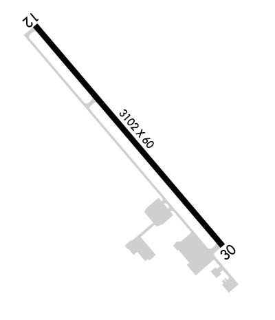
    Runway Identifications
    Runway Identification: 12/30
    Length: 3102 ft
    Width: 60 ft
    Surface: ASPHALT-GOOD CONDITION
    Edge lights: Medium Intensity

    Treatment: NONE

     Runway: 12   Runway: 30
    Mag heading: 124°Mag heading: 304°
    Rwy Slope: .00% UpRwy Slope: .00% Down
    Approach: Approach:
    Pattern: Right TrafficPattern: Left Traffic
    Markings: BASICMarkings: BASIC
    Marking Condition: FAIRMarking Condition: FAIR
    Arresting Dev: Arresting Dev:
    Lat & Long: N3651.8  W12028.1Lat. & Long.: N3651.4  W12027.7
    Elev: 156.9 ft. MSLElev: 157.0 ft. MSL
    TCH: TCH: 29 ft. AGL
    Visual Glide Path: Visual Glide Path: 3.00 degrees
    Displaced Threshold: NoDisplaced Threshold: No
    Touchdown Zone: YESTouchdown Zone: YES
    Touchdown Elev.: 157.1 feetTouchdown Elev.: 157.2 feet
    Visual Glide Slope: Visual Glide Slope: 2-Box VASI on LEFT side of Runway
    RVR Equipment: RVR Equipment:
    RVV Equipment: NORVV Equipment: NO
    Approach Lights: Approach Lights:
    REIL: NOREIL: NO
    Centerline Lights: NOCenterline Lights: NO
    Touchdown lights: NOTouchdown lights: NO
    Runway Category: Runway with a Visual ApproachRunway Category: Runway with a Visual Approach
    Declared Distances: Declared Distances:
    Obstructions: ROADObstructions: ROAD
    Marked: NOT Marked/LightedMarked: NOT Marked/Lighted
    Clearance slope: 20:1Clearance slope: 33:1
    Obstruction height: 10 feet AGLObstruction height: 15 feet AGL
    Dist. from runway: 400 feetDist. from runway: 700 feet
    Centerline offset: Centerline offset:
    Comments: RWY 12 +2' BERM, 6' FENCE & 5' DITCH 80'-140' FM RWY END 125'L TO 125'R.Comments:
    C:/P: