Click here for more info on on SMS!

KF31

LAKE TEXOMA STATE PARK
KINGSTON
OK
Time Zone: Central
Lat: N 3359.5
Long: W 09638.6
Elev: 693
Var: -06
Longest Runway: 3000
CTAF: 122.8

FBO & Flight Services info for KF31

FBOs: Update your Fuel Prices

AIRPORT MANAGERPh: 580-564-2566
-
-
Service
Jet
100LL
SAF
MoGas
Fuel Avail: NO FUEL AVAILABLE
Full        Last Update: 04/24/2024 06:02:16

Self        
If you are an FBO, call 1-203-262-1700 to update your info or email: FltPlan.Advertising@garmin.com
Advertise your FBO on FltPlan.com

Runway & Approach Info for KF31
Rwy
Length
Land Dist**
Approach*
  Rwy
Length
Land Dist**
Approach*
18
3000x50  3000'          
 
  
36
  3000x50  3000'          
 
 * only ILS, LOC, LDA, and SDF approaches to a specific runway are shown
** For any Declared Landing Distance Available, please see A/FD or Approach plates
Runway Weight Capability (lbs.) Help
Runway IDSingle WheelDouble WheelDouble Tandem WheelDual Double Wheel
18/364,000N/AN/AN/A
These numbers are Advisory and are not limits.   The Airport Manager should have more accurate Weight Limits
Approach Charts
FltPlan does not have IFR approach charts available for KF31.
Current Weather/Notams
Customs Information Send updates to Support@FltPlan.com
Customs Not Available
Database effective 05/16/2024
Airport Diagram of KF31
Airport Diagram might not be current.

Facility Name: LAKE TEXOMA STATE PARK
City Name: KINGSTON
County: MARSHALL
State abbrev: OK
State Name: OKLAHOMA
   
Ownership: PUBLICLY OWNED
Use: OPEN TO THE PUBLIC
Owner's Name: CORP OF ENGINEERS
Address: OK DEP OF TOURISM & REC, LESSEE, PO BOX 52002
 OKLAHOMA CITY, OK 73105
Owner's Phone: (580) 564-2566
  
Manager's Name: KEVIN NUNNELEE
Address: 11500 PARK OFFICE RD, 1988 STATE PARK RD.
 KINGSTON, OK 73439
Phone: 580-564-2566; AFT HR - 580-564-5515.
   
FAA Region: SOUTHWEST
FAA Field Office: AOK


Sunrise / Sunset times for LAKE TEXOMA STATE PARK

DateSunriseSunset
04/23/24 Tuesday6:4520:05
04/24/24 Wednesday6:4420:06
04/25/24 Thursday6:4320:06
04/26/24 Friday6:4220:07
04/27/24 Saturday6:4120:08
04/28/24 Sunday6:4020:09
04/29/24 Monday6:3920:09
04/30/24 Tuesday6:3820:10
05/01/24 Wednesday6:3720:11
05/02/24 Thursday6:3620:12
05/03/24 Friday6:3520:13
05/04/24 Saturday6:3420:13
05/05/24 Sunday6:3320:14
05/06/24 Monday6:3220:15

Airport Facilities

Airport Attendance ScheduleUNATTENDED
Airport Status OPERATIONAL (This Status can change at any time - please check NOTAMS)
Airport Lighting ScheduleACTVT MIRL RWY 18/36 - CTAF. MIRL RWY 18/36 PRESET LOW INTST; INCR INTST - CTAF.
Airport Storage AvailableTie Downs
Extra Services AvailableNONE
Wind IndicatorYES - (lighted)
Control TowerNO
CTAF Frequency122.800
Unicom Frequency122.800
Rotating Beacon ColorWG; ROTG BCN OTS INDEFLY.
Segmented CircleNO
Landing FeeNO

Airport Inspection Data

Airport InspectedSTATE - performed by STATE AERONAUTICAL PERSONNEL
Inspection Date02/29/2024

Airport Services

Type of Fuel AvailableNone
Airframe Repair ServiceNone
Power Plant Repair ServiceNone

Geographic Data

LatitudeN3359.5
LongitudeW09638.6 (ESTIMATED)
Arpt Elevation693ft (ESTIMATED)
Magnetic Variation06E
4 miles Eof KINGSTON
Traffic Pattern Altitude
Sectional ChartDALLAS-FT WORTH

Aircraft Data

Operations (Reported)YearlyAvg. Daily
General Aviation Transient 3001
General Aviation Local 00
Air Taxi 00
Commerical 00
Commuter 00
Military 00
Aircraft based on Field
General Aviation Singles 0
General Aviation Multi 0
Jet Aircraft 0
General Aviation Helicopters 0
Military Aircraft 0
Gliders 0
Ultralights 0

FAA Services

FSS on field NO
FSS tie-in MC ALESTER
FSS Phone 1-800-WX-BRIEF
Who issues Notams MLC
Notam D service at airport YES
ARTCC Name FORT WORTH

Federal Status

Airport Certification
Aircraft Rescue & Firefighting IndexNone
Airport of EntryNo
Custom Landing RightsNo
Joint Civil/MilitaryNo
Military Landing rightsYES

Federal Agreements

NATIONAL PLAN OF INTEGRATED AIRPORT SYSTEMS (NPIAS)
ASSURANCES PURSUANT TO TITLE VI, CIVIL RIGHTS ACT OF 1964
GRANT AGREEMENT HAS EXPIRED; HOWEVER, AGREEMENT REMAINS IN EFFECT FOR THIS FACILITY AS LONG AS IT IS PUBLIC USE.

Remarks

DEER & GEESE ON & INVOF RWY.
FOR CD CTC FORT WORTH ARTCC AT 817-858-7584.
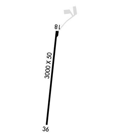
Runway Identifications
Runway Identification: 18/36
Length: 3000 ft
Width: 50 ft
Surface: ASPHALT-FAIR CONDITION
Edge lights: Medium Intensity

Treatment: NONE

 Runway: 18   Runway: 36
Mag heading: 180°Mag heading:
Approach: Approach:
Pattern: Left TrafficPattern: Left Traffic
Markings: BASICMarkings: BASIC
Marking Condition: FAIRMarking Condition: FAIR
Arresting Dev: Arresting Dev:
Lat & Long: N3359.7  W09638.5Lat. & Long.: N3359.2  W09638.6
Elev: N/AElev: N/A
TCH: TCH:
Visual Glide Path: Visual Glide Path:
Displaced Threshold: NoDisplaced Threshold: No
Touchdown Zone: NOTouchdown Zone: NO
Touchdown Elev.: Touchdown Elev.:
Visual Glide Slope: Visual Glide Slope:
RVR Equipment: RVR Equipment:
RVV Equipment: NORVV Equipment: NO
Approach Lights: Approach Lights:
REIL: NOREIL: NO
Centerline Lights: NOCenterline Lights: NO
Touchdown lights: NOTouchdown lights: NO
Runway Category: Runway with a Visual ApproachRunway Category: Runway with a Visual Approach
Declared Distances: Declared Distances:
Obstructions: Obstructions: TREES
Marked: Marked: NOT Marked/Lighted
Clearance slope: 20:1Clearance slope: 2:1
Obstruction height: Obstruction height: 36 feet AGL
Dist. from runway: Dist. from runway: 272 feet
Centerline offset: Centerline offset: 19 feet left of centerline
Comments: Comments: RISING TRRN 90 FT FM THR.
C:/P: