Click here for more info on on SMS!

KF10

HENRYETTA MUNI
HENRYETTA
OK
Time Zone: Central
Lat: N 3524.4
Long: W 09600.9
Elev: 849
Var: -04
Longest Runway: 3501
CTAF: 122.8

FBO & Flight Services info for KF10

FBOs: Update your Fuel Prices
Providing high quality fuel and services to you and your customers, from Phillips 66 Aviation.
Ph: 918-652-8634 Fax: 918-652-8816 Freq: 122.8Website-
Service
Jet
100LL
SAF
MoGas
Full        Last Update: 04/19/2024 07:32

Self        
Misc. Info: Address: 10249 LOBOLOLLY RD   HENRYETTA, OK 74437

If you are an FBO, call 1-203-262-1700 to update your info or email: FltPlan.Advertising@garmin.com
Advertise your FBO on FltPlan.com

Runway & Approach Info for KF10
Rwy
Length
Land Dist**
Approach*
  Rwy
Length
Land Dist**
Approach*
18
3501x50  3501'          
 
  
36
  3501x50  3501'          
 
 * only ILS, LOC, LDA, and SDF approaches to a specific runway are shown
** For any Declared Landing Distance Available, please see A/FD or Approach plates
Runway Weight Capability (lbs.) Help
Runway IDSingle WheelDouble WheelDouble Tandem WheelDual Double Wheel
18/3612,000N/AN/AN/A
These numbers are Advisory and are not limits.   The Airport Manager should have more accurate Weight Limits
Approach Charts
Approaches    
Current Weather/Notams
Customs Information Send updates to Support@FltPlan.com
Customs Not Available
Database effective 05/16/2024
Airport Diagram of KF10
Airport Diagram might not be current.

Facility Name: HENRYETTA MUNI
City Name: HENRYETTA
County: OKMULGEE
State abbrev: OK
State Name: OKLAHOMA
   
Ownership: PUBLICLY OWNED
Use: OPEN TO THE PUBLIC
Owner's Name: CITY OF HENRYETTA
Address: CITY HALL, 115 S. 4TH ST
 HENRYETTA, OK 74437
Owner's Phone: 918-652-3348
  
Manager's Name: RON CASEY
Address: PO BOX 608, 10249 LOBLOLLY RD.
 HENRYETTA, OK 74437
Phone: 918-652-3348
   
FAA Region: SOUTHWEST
FAA Field Office: AOK


Sunrise / Sunset times for HENRYETTA MUNI

DateSunriseSunset
04/23/24 Tuesday6:4120:04
04/24/24 Wednesday6:4020:05
04/25/24 Thursday6:3820:06
04/26/24 Friday6:3720:07
04/27/24 Saturday6:3620:08
04/28/24 Sunday6:3520:08
04/29/24 Monday6:3420:09
04/30/24 Tuesday6:3320:10
05/01/24 Wednesday6:3220:11
05/02/24 Thursday6:3120:12
05/03/24 Friday6:3020:13
05/04/24 Saturday6:2920:13
05/05/24 Sunday6:2820:14
05/06/24 Monday6:2720:15

Airport Facilities

Airport Attendance ScheduleUNATTENDED
Airport Status OPERATIONAL (This Status can change at any time - please check NOTAMS)
Airport Lighting ScheduleDUSK-DAWN. ACTVT MIRL RY 18/36 - CTAF.
Airport Storage AvailableTie Downs, Hanger
Extra Services AvailableNONE
Wind IndicatorYES - (lighted)
Control TowerNO
CTAF Frequency122.800
Unicom Frequency122.800
Rotating Beacon ColorWG
Segmented CircleYES
Landing FeeNO

Airport Inspection Data

Airport InspectedSTATE - performed by STATE AERONAUTICAL PERSONNEL
Inspection Date10/04/2022

Airport Services

Type of Fuel AvailableNone
Airframe Repair ServiceNONE
Power Plant Repair ServiceNONE

Geographic Data

LatitudeN3524.4
LongitudeW09600.9 (ESTIMATED)
Arpt Elevation849ft (SURVEYED)
Magnetic Variation04E
3 miles SWof HENRYETTA
Traffic Pattern Altitude
Sectional ChartDALLAS-FT WORTH

Aircraft Data

Operations (Reported)YearlyAvg. Daily
General Aviation Transient 10003
General Aviation Local 30008
Air Taxi 00
Commerical 00
Commuter 00
Military 100
Aircraft based on Field
General Aviation Singles 3
General Aviation Multi 0
Jet Aircraft 0
General Aviation Helicopters 0
Military Aircraft 0
Gliders 0
Ultralights 0

FAA Services

FSS on field NO
FSS tie-in MC ALESTER
FSS Phone 1-800-WX-BRIEF
Who issues Notams MLC
Notam D service at airport YES
ARTCC Name FORT WORTH

Federal Status

Airport Certification
Aircraft Rescue & Firefighting IndexNone
Airport of EntryNo
Custom Landing RightsNo
Joint Civil/MilitaryNo
Military Landing rightsYES

Federal Agreements

NATIONAL PLAN OF INTEGRATED AIRPORT SYSTEMS (NPIAS)
GRANT AGREEMENTS UNDER FAAP/ADAP/AIP
ASSURANCES PURSUANT TO TITLE VI, CIVIL RIGHTS ACT OF 1964

Remarks

THIS AIRPORT HAS BEEN SURVEYED BY THE NATIONAL GEODETIC SURVEY.
FOR CD CTC FORT WORTH ARTCC AT 817-858-7584.
Airport Communications & Frequencies:
CTAF Frequency:
122.800
Unicom Frequency:
122.800
Remarks
  • APCH/DEP CTL SVC PRVDD BY FORT WORTH ARTCC (ZFW) ON FREQS 132.2/338.35 (MC ALESTER RCAG).
  • Runway Identifications
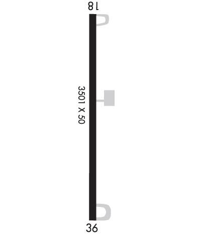
    Runway Identification: 18/36
    Length: 3501 ft
    Width: 50 ft
    Surface: ASPHALT-FAIR CONDITION
    Edge lights: Medium Intensity

    Treatment: NONE

     Runway: 18   Runway: 36
    Mag heading: 176°Mag heading: 356°
    Rwy Slope: .54% UpRwy Slope: -.54% Down
    Approach: Approach:
    Pattern: Left TrafficPattern: Left Traffic
    Markings: BASICMarkings: NONPRECISION INSTRUMENT
    Marking Condition: POOR; MARKINGS SEVERELY FADED.Marking Condition: POOR; MARKINGS SEVERELY FADED.
    Arresting Dev: Arresting Dev:
    Lat & Long: N3524.7  W09600.9Lat. & Long.: N3524.1  W09601.0
    Elev: 830.0 ft. MSLElev: 849.0 ft. MSL
    TCH: 45 ft. AGLTCH:
    Visual Glide Path: 3.50 degreesVisual Glide Path:
    Displaced Threshold: NoDisplaced Threshold: No
    Touchdown Zone: YESTouchdown Zone: YES
    Touchdown Elev.: 830.0 feetTouchdown Elev.: 849.0 feet
    Visual Glide Slope: PULSATING/STEADY BURNING VASI ON LEFT SIDE OF RUNWAY; OTS INDEFLY.Visual Glide Slope:
    RVR Equipment: RVR Equipment:
    RVV Equipment: NORVV Equipment: NO
    Approach Lights: Approach Lights:
    REIL: NOREIL: NO
    Centerline Lights: NOCenterline Lights: NO
    Touchdown lights: NOTouchdown lights: NO
    Runway Category: Runway with a Visual ApproachRunway Category: Runway with a Non-precision Approach
    Declared Distances: Declared Distances:
    Obstructions: TREESObstructions: TREES
    Marked: NOT Marked/LightedMarked: NOT Marked/Lighted
    Clearance slope: 1:1Clearance slope: 2:1
    Obstruction height: 41 feet AGLObstruction height: 28 feet AGL
    Dist. from runway: 253 feetDist. from runway: 257 feet
    Centerline offset: 18 left of centerlineCenterline offset: 317 feet left of centerline
    Comments: Comments:
    C:/P: