Current Weather/Notams (Metars, TAFs, Notams, NWS Forecast, PIREPS, and nearby weather)
Customs Information Send updates to Support@FltPlan.com
Customs Not Available
Database effective 05/16/2024
Airport Diagram might not be current.
|
| Facility Name: | CAMERON MEML |
| City Name: | CAMERON |
| County: | CLINTON |
| State abbrev: | MO |
| State Name: | MISSOURI |
| | |
| Ownership: | PUBLICLY OWNED |
| Use: | OPEN TO THE PUBLIC |
| Owner's Name: | CITY OF CAMERON |
| Address: | 205 NORTH MAIN |
| | CAMERON, MO 64429 |
| Owner's Phone: | 816-632-2177 |
| | |
| Manager's Name: | ERIC EVANS |
| Address: | 11766 NORTHEAST A HWY |
| | CAMERON, MO 64429 |
| Phone: | 816-632-2423 |
| | |
| FAA Region: | CENTRAL |
| FAA Field Office: | NONE |
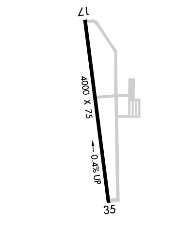
Runway Identifications
Runway Identification: 17/35Length: 4000 ft
Width: 75 ft
Surface: CONCRETE-GOOD CONDITION
Edge lights: Medium IntensityTreatment: NONE
| | Runway: 17 | | Runway: 35 |
| Mag heading: | 172° | Mag heading: | 352° |
| Rwy Slope: | -.42% Down | Rwy Slope: | .42% Up |
| Approach: | | Approach: | |
| Pattern: | Left Traffic | Pattern: | Left Traffic |
| Markings: | NONPRECISION INSTRUMENT | Markings: | NONPRECISION INSTRUMENT |
| Marking Condition: | GOOD | Marking Condition: | GOOD |
| Arresting Dev: | | Arresting Dev: | |
| Lat & Long: | N3944.0 W09416.6 | Lat. & Long.: | N3943.3 W09416.5 |
| Elev: | 1040.1 ft. MSL | Elev: | 1023.1 ft. MSL |
| TCH: | 21 ft. AGL | TCH: | 22 ft. AGL |
| Visual Glide Path: | 3.00 degrees | Visual Glide Path: | 3.00 degrees |
| Displaced Threshold: | No | Displaced Threshold: | No |
| Touchdown Zone: | YES | Touchdown Zone: | YES |
| Touchdown Elev.: | 1040.1 feet | Touchdown Elev.: | 1034.6 feet |
| Visual Glide Slope: | 4-Light PAPI on LEFT side of Runway | Visual Glide Slope: | 4-Light PAPI on LEFT side of Runway |
| RVR Equipment: | | RVR Equipment: | |
| RVV Equipment: | NO | RVV Equipment: | NO |
| Approach Lights: | | Approach Lights: | |
| REIL: | YES | REIL: | YES |
| Centerline Lights: | NO | Centerline Lights: | NO |
| Touchdown lights: | NO | Touchdown lights: | NO |
| Runway Category: | Runway with a Non-precision Approach having visibility minimums greater than 3/4 mile | Runway Category: | Runway with a Non-precision Approach having visibility minimums greater than 3/4 mile |
| Declared Distances: | | Declared Distances: | |
| Obstructions: | TREES | Obstructions: | |
| Marked: | NOT Marked/Lighted | Marked: | |
| Clearance slope: | 26:1 | Clearance slope: | 34:1 |
| Obstruction height: | 39 feet AGL | Obstruction height: | |
| Dist. from runway: | 1234 feet | Dist. from runway: | |
| Centerline offset: | 310 left of centerline | Centerline offset: | |
| Comments: | | Comments: | |