| |||||||||||||||||||||||||||||||||||||||||||||||||||||||||||||||||||||
| |||||||||||||||||||||||||||||||||||||||||||||||||||||||||||||||||||||
| |||||||||||||||||||||||||||||||||||||||||||||||||||||||||||||||||||||
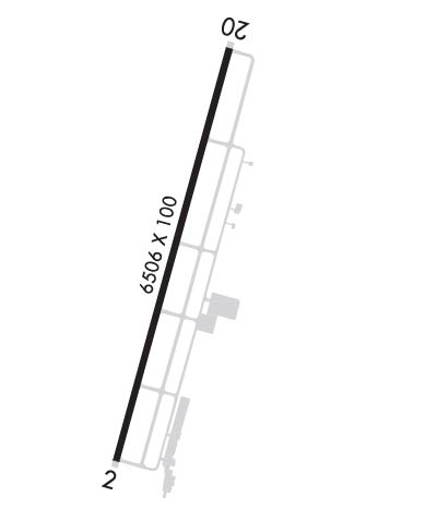
| Rwy | Rwy | |||||||
| 6506x100 | 6506' | 109.55 - 019° | 6506x100 | 6506' | ||||
| Runway ID | Single Wheel | Double Wheel | Double Tandem Wheel | Dual Double Wheel |
| 02/20 | 75,000 | 120,000 | N/A | N/A |
| These numbers are Advisory and are not limits. The Airport Manager should have more accurate Weight Limits | ||||
 Airport Diagram might not be current. | |
| Facility Name: | HEART OF GEORGIA RGNL |
| City Name: | EASTMAN |
| County: | DODGE |
| State abbrev: | GA |
| State Name: | GEORGIA |
| Ownership: | PUBLICLY OWNED |
| Use: | OPEN TO THE PUBLIC |
| Owner's Name: | HEART OF GA REG APT AUTH |
| Address: | 317 AIRPORT RD. |
| EASTMAN, GA 31023 | |
| Owner's Phone: | 478-220-5091; TWR PHONE 478-448-4713. MGR CELL PHONE 478-231-8305. |
| Manager's Name: | JEFF FORDHAM |
| Address: | 317 AIRPORT RD. |
| EASTMAN, GA 31023 | |
| Phone: | 478-220-5091; TWR PHONE: 478-448-4713. MGR CELL PHONE 478-231-8305 |
| FAA Region: | SOUTHERN |
| FAA Field Office: | ATL |
| Date | Sunrise | Sunset |
|---|---|---|
| 04/25/24 Thursday | 6:52 | 20:10 |
| 04/26/24 Friday | 6:50 | 20:10 |
| 04/27/24 Saturday | 6:49 | 20:11 |
| 04/28/24 Sunday | 6:48 | 20:12 |
| 04/29/24 Monday | 6:47 | 20:13 |
| 04/30/24 Tuesday | 6:46 | 20:13 |
| 05/01/24 Wednesday | 6:46 | 20:14 |
| 05/02/24 Thursday | 6:45 | 20:15 |
| 05/03/24 Friday | 6:44 | 20:15 |
| 05/04/24 Saturday | 6:43 | 20:16 |
| 05/05/24 Sunday | 6:42 | 20:17 |
| 05/06/24 Monday | 6:41 | 20:18 |
| 05/07/24 Tuesday | 6:40 | 20:18 |
| 05/08/24 Wednesday | 6:39 | 20:19 |
| Airport Attendance Schedule | MON-SAT 0800-1800, SUN 1300-1700 |
| Airport Status | OPERATIONAL (This Status can change at any time - please check NOTAMS) |
| Airport Lighting Schedule | ACTVT MALSR RWY 02; REIL RWY 20; PAPI RWY 02 & 20; HIRL RWY 02/20 - CTAF.; DUSK-2400. |
| Airport Storage Available | Tie Downs |
| Extra Services Available | Flight Instruction, Aircraft Rental, Aircraft Sales |
| Wind Indicator | YES - (lighted) |
| Control Tower | YES |
| CTAF Frequency | 124.550 |
| Unicom Frequency | 122.950 |
| Rotating Beacon Color | WG |
| Segmented Circle | YES |
| Landing Fee | NO |
| Airport Inspected | STATE - performed by STATE AERONAUTICAL PERSONNEL |
| Inspection Date | 05/19/2023 |
| Type of Fuel Available | Grade 100LL, JET A; -1024 HR SELF-FUELING WITH CREDIT CARD. |
| Airframe Repair Service | MAJOR |
| Power Plant Repair Service | MAJOR |
| Latitude | N3213.0 |
| Longitude | W08307.7 (ESTIMATED) |
| Arpt Elevation | 303ft (SURVEYED) |
| Magnetic Variation | 04W |
| 3 miles E | of EASTMAN |
| Traffic Pattern Altitude | |
| Sectional Chart | ATLANTA |
| Operations (Reported) | Yearly | Avg. Daily |
|---|---|---|
| General Aviation Transient | 23827 | 65 |
| General Aviation Local | 45000 | 123 |
| Air Taxi | 0 | 0 |
| Commerical | 0 | 0 |
| Commuter | 0 | 0 |
| Military | 100 | 0 |
| Aircraft based on Field | |
|---|---|
| General Aviation Singles | 43 |
| General Aviation Multi | 3 |
| Jet Aircraft | 0 |
| General Aviation Helicopters | 5 |
| Military Aircraft | 0 |
| Gliders | 0 |
| Ultralights | 0 |
| FSS on field | NO |
| FSS tie-in | MACON |
| FSS Phone | 1-800-WX-BRIEF |
| Who issues Notams | MCN |
| Notam D service at airport | YES |
| ARTCC Name | JACKSONVILLE |
| Airport Certification | |
| Aircraft Rescue & Firefighting Index | None |
| Airport of Entry | No |
| Custom Landing Rights | No |
| Joint Civil/Military | No |
| Military Landing rights | YES |
| NATIONAL PLAN OF INTEGRATED AIRPORT SYSTEMS (NPIAS) |
| GRANT AGREEMENTS UNDER FAAP/ADAP/AIP |
| ASSURANCES PURSUANT TO TITLE VI, CIVIL RIGHTS ACT OF 1964 |
| FLT TRNG IN AREA. |
| DEER AND OTR WILDLIFE INVOF ARPT. |
| CTAF & TWR FREQ - 124.55. |
| FOR CD WHEN ATCT IS CLSD CTC JACKSONVILLE ARTCC AT 904-845-1592. |
Airport Communications & Frequencies:
| |||||||||||||||||||
| Runway: 02 | Runway: 20 | ||
| Mag heading: | 19° | Mag heading: | 199° |
| Rwy Slope: | .04% Up | Rwy Slope: | -.04% Down |
| Approach: | LOC/GS | Approach: | |
| Pattern: | Left Traffic | Pattern: | Left Traffic |
| Markings: | PRECISION INSTRUMENT | Markings: | PRECISION INSTRUMENT |
| Marking Condition: | GOOD | Marking Condition: | GOOD |
| Arresting Dev: | Arresting Dev: | ||
| Lat & Long: | N3212.5 W08307.9 | Lat. & Long.: | N3213.5 W08307.6 |
| Elev: | 295.1 ft. MSL | Elev: | 298.0 ft. MSL |
| TCH: | 45 ft. AGL | TCH: | 45 ft. AGL |
| Visual Glide Path: | 3.00 degrees | Visual Glide Path: | 3.00 degrees |
| Displaced Threshold: | No | Displaced Threshold: | No |
| Touchdown Zone: | YES | Touchdown Zone: | YES |
| Touchdown Elev.: | 299.5 feet | Touchdown Elev.: | 303.4 feet |
| Visual Glide Slope: | 4-Light PAPI on LEFT side of Runway | Visual Glide Slope: | 4-Light PAPI on LEFT side of Runway |
| RVR Equipment: | RVR Equipment: | ||
| RVV Equipment: | NO | RVV Equipment: | NO |
| Approach Lights: | MALSR - 1,400 foot medium intensity approach lighting system with runway alignment indicator lights | Approach Lights: | |
| REIL: | NO | REIL: | YES |
| Centerline Lights: | NO | Centerline Lights: | NO |
| Touchdown lights: | NO | Touchdown lights: | NO |
| Runway Category: | Precision Instrument Runway | Runway Category: | Runway with a Non-precision Approach having visibility minimums greater than 3/4 mile |
| Declared Distances: | Declared Distances: | ||
| Comments: | Comments: | 10 FT TREES, 363 FT RIGHT OF CNTRLN AT THLD. |