Current Weather/Notams (Metars, TAFs, Notams, NWS Forecast, PIREPS, and nearby weather)
Customs Information Send updates to Support@FltPlan.com
Phone 508-994-5158
Fax 508-979-1285
Comments 3 hrs advance notice required. Business hrs 0800-1700 Monday-Friday. *Call prior to 1700 on preceding weekday.
Database effective 05/16/2024
Airport Diagram might not be current.
|
| Facility Name: | NEW BEDFORD RGNL |
| City Name: | NEW BEDFORD |
| County: | BRISTOL |
| State abbrev: | MA |
| State Name: | MASSACHUSETTS |
| | |
| Ownership: | PUBLICLY OWNED |
| Use: | OPEN TO THE PUBLIC |
| Owner's Name: | CITY OF NEW BEDFORD |
| Address: | WILLIAMS ST |
| | NEW BEDFORD, MA 02740 |
| Owner's Phone: | 508-979-1410 |
| | |
| Manager's Name: | SCOT SERVIS |
| Address: | 1569 AIRPORT RD |
| | NEW BEDFORD, MA 02746 |
| Phone: | 508-991-6161 |
| | |
| FAA Region: | NEW ENGLAND |
| FAA Field Office: | NONE |
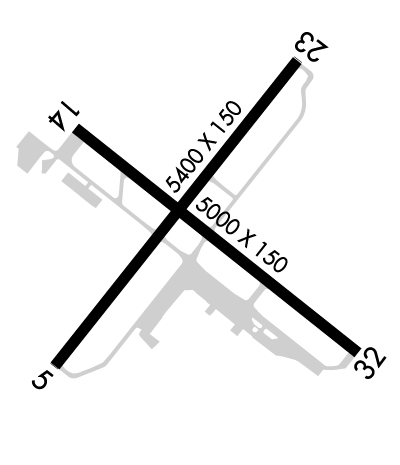
Runway Identifications
Runway Identification: 05/23Length: 5400 ft
Width: 150 ft
Surface: ASPHALT-GOOD CONDITION
Edge lights: High IntensityTreatment: GROOVED
| | Runway: 05 | | Runway: 23 |
| Mag heading: | 54° | Mag heading: | 234° |
| Rwy Slope: | .27% Up | Rwy Slope: | -.27% Down |
| Approach: | ILS/DME | Approach: | |
| Pattern: | Left Traffic | Pattern: | Left Traffic |
| Markings: | PRECISION INSTRUMENT | Markings: | PRECISION INSTRUMENT |
| Marking Condition: | GOOD | Marking Condition: | GOOD |
| Arresting Dev: | | Arresting Dev: | |
| Lat & Long: | N4140.3 W07057.9 | Lat. & Long.: | N4141.0 W07057.2 |
| Elev: | 64.4 ft. MSL | Elev: | 79.1 ft. MSL |
| TCH: | | TCH: | 46 ft. AGL |
| Visual Glide Path: | | Visual Glide Path: | 3.00 degrees |
| Displaced Threshold: | No | Displaced Threshold: | 400 feet |
| Touchdown Zone: | YES | Touchdown Zone: | YES |
| Touchdown Elev.: | 70.4 feet | Touchdown Elev.: | 78.0 feet |
| Visual Glide Slope: | | Visual Glide Slope: | 4-Light PAPI on LEFT side of Runway |
| RVR Equipment: | TOUCHDOWN | RVR Equipment: | ROLLOUT |
| RVV Equipment: | NO | RVV Equipment: | NO |
| Approach Lights: | MALSR - 1,400 foot medium intensity approach lighting system with runway alignment indicator lights | Approach Lights: | MALSR - 1,400 foot medium intensity approach lighting system with runway alignment indicator lights |
| REIL: | NO | REIL: | NO |
| Centerline Lights: | NO | Centerline Lights: | NO |
| Touchdown lights: | NO | Touchdown lights: | NO |
| Runway Category: | Precision Instrument Runway | Runway Category: | Runway with a Non-precision Approach having visibility minimums greater than 3/4 mile |
| Declared Distances: | | Declared Distances: | |
| Obstructions: | TREE | Obstructions: | TREE |
| Marked: | NOT Marked/Lighted | Marked: | NOT Marked/Lighted |
| Clearance slope: | 50:1 | Clearance slope: | 34:1; APCH SLP 50:1 AT DTHR. |
| Obstruction height: | 20 feet AGL | Obstruction height: | 35 feet AGL |
| Dist. from runway: | 1200 feet | Dist. from runway: | 1400 feet |
| Centerline offset: | B | Centerline offset: | 125B |
| Comments: | | Comments: | |
Runway Identification: 14/32Length: 5002 ft
Width: 75 ft
Surface: ASPHALT-FAIR CONDITION
Edge lights: Medium IntensityTreatment: NONE
| | Runway: 14 | | Runway: 32 |
| Mag heading: | 144° | Mag heading: | 324° |
| Rwy Slope: | -.22% Down | Rwy Slope: | .22% Up |
| Approach: | | Approach: | |
| Pattern: | Left Traffic | Pattern: | Left Traffic |
| Markings: | BASIC | Markings: | BASIC |
| Marking Condition: | GOOD | Marking Condition: | GOOD |
| Arresting Dev: | | Arresting Dev: | |
| Lat & Long: | N4140.8 W07057.8 | Lat. & Long.: | N4140.3 W07057.0 |
| Elev: | 77.3 ft. MSL | Elev: | 66.2 ft. MSL |
| TCH: | 50 ft. AGL | TCH: | 50 ft. AGL |
| Visual Glide Path: | 3.42 degrees | Visual Glide Path: | 3.50 degrees |
| Displaced Threshold: | No | Displaced Threshold: | No |
| Touchdown Zone: | YES | Touchdown Zone: | YES |
| Touchdown Elev.: | 77.3 feet | Touchdown Elev.: | 68.4 feet |
| Visual Glide Slope: | 4-Light PAPI on LEFT side of Runway | Visual Glide Slope: | 4-Light PAPI on LEFT side of Runway |
| RVR Equipment: | | RVR Equipment: | |
| RVV Equipment: | NO | RVV Equipment: | NO |
| Approach Lights: | | Approach Lights: | |
| REIL: | NO | REIL: | YES |
| Centerline Lights: | NO | Centerline Lights: | NO |
| Touchdown lights: | NO | Touchdown lights: | NO |
| Runway Category: | Runway with a Non-precision Approach having visibility minimums greater than 3/4 mile | Runway Category: | Runway with a Non-precision Approach having visibility minimums greater than 3/4 mile |
| Declared Distances: | | Declared Distances: | |
| Obstructions: | TREE | Obstructions: | TREES |
| Marked: | NOT Marked/Lighted | Marked: | NOT Marked/Lighted |
| Clearance slope: | 20:1 | Clearance slope: | 36:1 |
| Obstruction height: | 10 feet AGL | Obstruction height: | 11 feet AGL |
| Dist. from runway: | 400 feet | Dist. from runway: | 600 feet |
| Centerline offset: | | Centerline offset: | 130 feet right of centerline |
| Comments: | | Comments: | |

