Current Weather/Notams (Metars, TAFs, Notams, NWS Forecast, PIREPS, and nearby weather)
Customs Information Send updates to Support@FltPlan.com
Customs Not Available
Database effective 04/18/2024
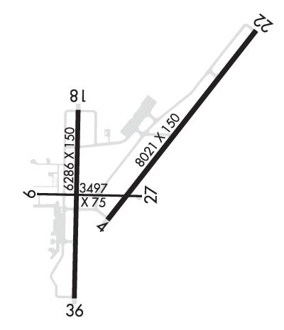
Airport Diagram might not be current. Facility Name: EVANSVILLE RGNL City Name: EVANSVILLE County: VANDERBURGH State abbrev: IN State Name: INDIANA Ownership: PUBLICLY OWNED Use: OPEN TO THE PUBLIC Owner's Name: EVANSVLLE-VANDERBURG ARPT AUTH Address: 7801 BUSSING DR EVANSVILLE, IN 47725-6799 Owner's Phone: 812-421-4401 Manager's Name: NATE HAHN Address: 7801 BUSSING DR EVANSVILLE, IN 47725-6799 Phone: 812-421-4401 FAA Region: GREAT LAKES FAA Field Office: CHI
Runway Identifications Help
Runway Identification: 04/22 Length: 8021 ftWidth: 150 ftSurface: ASPHALT-GOOD CONDITIONEdge lights: High Intensity Treatment: GROOVEDWeight: PCN 33 /F/B/W/U Runway: 04 Runway: 22 Mag heading: 41° Mag heading: 221° Rwy Slope: .49% Up Rwy Slope: -.49% Down Approach: ILS/DME Approach: ILS/DME Pattern: Left Traffic Pattern: Left Traffic Markings: PRECISION INSTRUMENT Markings: PRECISION INSTRUMENT Marking Condition: GOOD Marking Condition: GOOD Arresting Dev: Arresting Dev: Lat & Long: N3802.2 W08731.8 Lat. & Long.: N3803.2 W08730.8 Elev: 382.8 ft. MSL Elev: 421.9 ft. MSL TCH: 48 ft. AGL TCH: Visual Glide Path: 3.00 degrees Visual Glide Path: Displaced Threshold: No Displaced Threshold: No Touchdown Zone: YES Touchdown Zone: YES Touchdown Elev.: 389.1 feet Touchdown Elev.: 421.9 feet Visual Glide Slope: 4-Light PAPI on RIGHT side of Runway Visual Glide Slope: RVR Equipment: ROLLOUT RVR Equipment: TOUCHDOWN RVV Equipment: NO RVV Equipment: NO Approach Lights: Approach Lights: MALSR - 1,400 foot medium intensity approach lighting system with runway alignment indicator lights REIL: YES REIL: NO Centerline Lights: NO Centerline Lights: NO Touchdown lights: NO Touchdown lights: NO Runway Category: Precision Instrument Runway Runway Category: Precision Instrument Runway Declared Distances: TORA:8021' TODA:8021' ASDA:8021' LDA:8021' Declared Distances: TORA:8021' TODA:8021' ASDA:8021' LDA:8021' Obstructions: TREE Obstructions: POLE Marked: NOT Marked/Lighted Marked: NOT Marked/Lighted Clearance slope: 47:1 Clearance slope: 50:1 Obstruction height: 119 feet AGL Obstruction height: 43 feet AGL Dist. from runway: 5713 feet Dist. from runway: 2843 feet Centerline offset: 12 left of centerline Centerline offset: 808 feet right of centerline Comments: Comments:
Runway Identification: 09/27 Length: 3497 ftWidth: 75 ftSurface: ASPHALT-GOOD CONDITIONEdge lights: Medium Intensity Treatment: NONEWeight: PCN 3 /F/B/Z/U Runway: 09 Runway: 27 Mag heading: 94° Mag heading: 274° Rwy Slope: .06% Up Rwy Slope: -.06% Down Approach: Approach: Pattern: Left Traffic Pattern: Left Traffic Markings: BASIC Markings: BASIC Marking Condition: GOOD Marking Condition: GOOD Arresting Dev: Arresting Dev: Lat & Long: N3802.3 W08732.3 Lat. & Long.: N3802.3 W08731.6 Elev: 381.5 ft. MSL Elev: 383.5 ft. MSL TCH: TCH: Visual Glide Path: Visual Glide Path: Displaced Threshold: 529 feet Displaced Threshold: 218 feet Touchdown Zone: YES Touchdown Zone: YES Touchdown Elev.: 383.5 feet Touchdown Elev.: 383.0 feet Visual Glide Slope: Visual Glide Slope: RVR Equipment: RVR Equipment: RVV Equipment: NO RVV Equipment: NO Approach Lights: Approach Lights: REIL: NO REIL: NO Centerline Lights: NO Centerline Lights: NO Touchdown lights: NO Touchdown lights: NO Runway Category: Runway with a Visual Approach Runway Category: Runway with a Visual Approach Declared Distances: TORA:3497' TODA:3497' ASDA:3497' LDA:2968' Declared Distances: TORA:3497' TODA:3497' ASDA:3497' LDA:3279' Obstructions: ROAD Obstructions: ROAD Marked: NOT Marked/Lighted Marked: NOT Marked/Lighted Clearance slope: 12:1; APCH RATIO 20:1 AT DTHR; 60 FT TREES 1400 FT FM THR 250 FT L. Clearance slope: 4:1; APCH RATIO 26:1 AT DTHR; 18 FT ROAD 475 FT FM THR 13 FT L. Obstruction height: 14 feet AGL Obstruction height: 17 feet AGL Dist. from runway: 375 feet Dist. from runway: 268 feet Centerline offset: 250 right of centerline Centerline offset: Comments: Comments:
Runway Identification: 18/36 Length: 6286 ftWidth: 150 ftSurface: ASPHALT-GOOD CONDITIONEdge lights: High Intensity Treatment: GROOVEDWeight: PCN 33 /F/B/Y/U Runway: 18 Runway: 36 Mag heading: 184° Mag heading: 4° Rwy Slope: -.20% Down Rwy Slope: .20% Up Approach: Approach: Pattern: Left Traffic Pattern: Left Traffic Markings: PRECISION INSTRUMENT Markings: PRECISION INSTRUMENT Marking Condition: GOOD Marking Condition: GOOD Arresting Dev: Arresting Dev: Lat & Long: N3802.8 W08732.0 Lat. & Long.: N3801.7 W08732.1 Elev: 395.6 ft. MSL Elev: 382.8 ft. MSL TCH: 50 ft. AGL TCH: 29 ft. AGL Visual Glide Path: 3.00 degrees Visual Glide Path: 3.00 degrees Displaced Threshold: No Displaced Threshold: 789 feet Touchdown Zone: YES Touchdown Zone: YES Touchdown Elev.: 395.6 feet Touchdown Elev.: 384.2 feet Visual Glide Slope: 4-Light PAPI on RIGHT side of Runway Visual Glide Slope: 4-Light PAPI on LEFT side of Runway RVR Equipment: RVR Equipment: RVV Equipment: NO RVV Equipment: NO Approach Lights: Approach Lights: REIL: YES REIL: YES Centerline Lights: NO Centerline Lights: NO Touchdown lights: NO Touchdown lights: NO Runway Category: D Runway Category: D Declared Distances: TORA:5497' TODA:5497' ASDA:5497' LDA:5497' Declared Distances: TORA:6286' TODA:6286' ASDA:6286' LDA:5497' Obstructions: POLE Obstructions: ROAD Marked: LIGHTED Marked: NOT Marked/Lighted Clearance slope: 19:1 Clearance slope: 5:1; APCH RATIO 25:1 AT DTHR; 51 FT LGTD BLDG 1296 FT FM THR 308 FT L; APCH RATIO 50:1 AT DTHR OVR ROAD. Obstruction height: 64 feet AGL Obstruction height: 15 feet AGL Dist. from runway: 1430 feet Dist. from runway: 277 feet Centerline offset: 120 right of centerline Centerline offset: 10 feet right of centerline Comments: Comments: