Current Weather/Notams (Metars, TAFs, Notams, NWS Forecast, PIREPS, and nearby weather)
Customs Information Send updates to Support@FltPlan.com
Customs Not Available
Database effective 04/18/2024
Airport Diagram might not be current.
|
| Facility Name: | NEW SMYRNA BEACH MUNI |
| City Name: | NEW SMYRNA BEACH |
| County: | VOLUSIA |
| State abbrev: | FL |
| State Name: | FLORIDA |
| | |
| Ownership: | PUBLICLY OWNED |
| Use: | OPEN TO THE PUBLIC |
| Owner's Name: | CITY OF NEW SMYRNA BEACH |
| Address: | 210 SAMS AVE |
| | NEW SMYRNA BEACH, FL 32168 |
| Owner's Phone: | (386) 410-2610 |
| | |
| Manager's Name: | ARVIN WEESE |
| Address: | NEW SMYRNA BEACH MUNI AIRPORT, 602 SKYLINE DRIVE |
| | NEW SMYRNA BEACH, FL 32168 |
| Phone: | (386) 410-2680 |
| | |
| FAA Region: | SOUTHERN |
| FAA Field Office: | ORL |
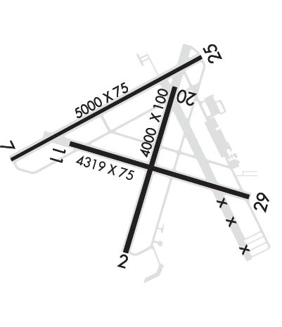
Runway Identifications
Runway Identification: 02/20Length: 4000 ft
Width: 100 ft
Surface: ASPHALT-POOR CONDITION
Edge lights: Treatment: NONE
Weight: PCN 5 /F/B/Z/T
| | Runway: 02 | | Runway: 20 |
| Mag heading: | 21° | Mag heading: | 201° |
| Rwy Slope: | .02% Up | Rwy Slope: | -.02% Down |
| Approach: | | Approach: | |
| Pattern: | Left Traffic | Pattern: | Left Traffic |
| Markings: | BASIC | Markings: | BASIC |
| Marking Condition: | GOOD | Marking Condition: | GOOD |
| Arresting Dev: | | Arresting Dev: | |
| Lat & Long: | N2902.9 W08057.0 | Lat. & Long.: | N2903.6 W08056.8 |
| Elev: | 8.1 ft. MSL | Elev: | 8.8 ft. MSL |
| TCH: | | TCH: | |
| Visual Glide Path: | | Visual Glide Path: | |
| Displaced Threshold: | 785 feet | Displaced Threshold: | No |
| Touchdown Zone: | YES | Touchdown Zone: | YES |
| Touchdown Elev.: | 8.8 feet | Touchdown Elev.: | 8.8 feet |
| Visual Glide Slope: | | Visual Glide Slope: | |
| RVR Equipment: | | RVR Equipment: | |
| RVV Equipment: | NO | RVV Equipment: | NO |
| Approach Lights: | | Approach Lights: | |
| REIL: | NO | REIL: | NO |
| Centerline Lights: | NO | Centerline Lights: | NO |
| Touchdown lights: | NO | Touchdown lights: | NO |
| Runway Category: | Runway with a Non-precision Approach having visibility minimums greater than 3/4 mile | Runway Category: | Runway with a Visual Approach |
| Declared Distances: | TORA:4000' TODA:4000' ASDA:4000' LDA:3215' | Declared Distances: | TORA:4000' TODA:4000' ASDA:3952' LDA:3952' |
| Obstructions: | ROAD | Obstructions: | TREES |
| Marked: | NOT Marked/Lighted | Marked: | NOT Marked/Lighted |
| Clearance slope: | 5:1; RWY 02 APCH RATIO 34:1 TO DSPLCD THR. | Clearance slope: | 21:1 |
| Obstruction height: | 16 feet AGL | Obstruction height: | 55 feet AGL |
| Dist. from runway: | 295 feet | Dist. from runway: | 1390 feet |
| Centerline offset: | 250 left of centerline | Centerline offset: | 250 feet right of centerline |
| Comments: | | Comments: | |
Runway Identification: 07/25Length: 5000 ft
Width: 75 ft
Surface: ASPHALT-GOOD CONDITION
Edge lights: Medium IntensityTreatment: NONE
Weight: PCN 25 /F/A/Y/T
| | Runway: 07 | | Runway: 25 |
| Mag heading: | 66° | Mag heading: | 246° |
| Rwy Slope: | .05% Up | Rwy Slope: | -.05% Down |
| Approach: | | Approach: | |
| Pattern: | Left Traffic | Pattern: | Left Traffic |
| Markings: | NONPRECISION INSTRUMENT | Markings: | NONPRECISION INSTRUMENT |
| Marking Condition: | FAIR | Marking Condition: | FAIR |
| Arresting Dev: | | Arresting Dev: | |
| Lat & Long: | N2903.3 W08057.5 | Lat. & Long.: | N2903.7 W08056.7 |
| Elev: | 7.5 ft. MSL | Elev: | 9.8 ft. MSL |
| TCH: | 48 ft. AGL | TCH: | 46 ft. AGL |
| Visual Glide Path: | 3.00 degrees | Visual Glide Path: | 3.00 degrees |
| Displaced Threshold: | 335 feet | Displaced Threshold: | 300 feet |
| Touchdown Zone: | YES | Touchdown Zone: | YES |
| Touchdown Elev.: | 8.6 feet | Touchdown Elev.: | 10.1 feet |
| Visual Glide Slope: | 4-Light PAPI on LEFT side of Runway | Visual Glide Slope: | 4-Light PAPI on LEFT side of Runway |
| RVR Equipment: | | RVR Equipment: | |
| RVV Equipment: | NO | RVV Equipment: | NO |
| Approach Lights: | | Approach Lights: | |
| REIL: | YES | REIL: | YES |
| Centerline Lights: | NO | Centerline Lights: | NO |
| Touchdown lights: | NO | Touchdown lights: | NO |
| Runway Category: | Runway with a Non-precision Approach having visibility minimums greater than 3/4 mile | Runway Category: | Runway with a Non-precision Approach having visibility minimums greater than 3/4 mile |
| Declared Distances: | TORA:5000' TODA:5000' ASDA:4853' LDA:4518' | Declared Distances: | TORA:5000' TODA:5000' ASDA:4763' LDA:4463' |
| Obstructions: | FENCE | Obstructions: | FENCE |
| Marked: | NOT Marked/Lighted | Marked: | NOT Marked/Lighted |
| Clearance slope: | RWY 07 APCH RATIO 34:1 TO DSPLCD THR. | Clearance slope: | RWY 25 APCH RATIO 34:1 TO DSPLCD THR. |
| Obstruction height: | 6 feet AGL | Obstruction height: | 6 feet AGL |
| Dist. from runway: | 56 feet | Dist. from runway: | 161 feet |
| Centerline offset: | 250 right of centerline | Centerline offset: | 250 feet right of centerline |
| Comments: | RWY 07 15 FT ROAD 83 FT FM AER, 250 FT R. | Comments: | RWY 25 15 FT ROAD 200 FT FM RWY END 250 FT RIGHT OF CNTRLN. |
Runway Identification: 11/29Length: 4319 ft
Width: 75 ft
Surface: ASPHALT-GOOD CONDITION
Edge lights: Medium IntensityTreatment: NONE
Weight: PCN 29 /F/A/Y/T
| | Runway: 11 | | Runway: 29 |
| Mag heading: | 111° | Mag heading: | 291° |
| Rwy Slope: | .06% Up | Rwy Slope: | -.06% Down |
| Approach: | | Approach: | |
| Pattern: | Left Traffic | Pattern: | Left Traffic |
| Markings: | NONPRECISION INSTRUMENT | Markings: | NONPRECISION INSTRUMENT |
| Marking Condition: | FAIR | Marking Condition: | FAIR |
| Arresting Dev: | | Arresting Dev: | |
| Lat & Long: | N2903.4 W08057.2 | Lat. & Long.: | N2903.2 W08056.4 |
| Elev: | 7.8 ft. MSL | Elev: | 10.4 ft. MSL |
| TCH: | 39 ft. AGL | TCH: | 35 ft. AGL |
| Visual Glide Path: | 3.50 degrees | Visual Glide Path: | 3.00 degrees |
| Displaced Threshold: | No | Displaced Threshold: | No |
| Touchdown Zone: | YES | Touchdown Zone: | YES |
| Touchdown Elev.: | 10.5 feet | Touchdown Elev.: | 10.8 feet |
| Visual Glide Slope: | 4-Light PAPI on LEFT side of Runway | Visual Glide Slope: | 4-Light PAPI on LEFT side of Runway |
| RVR Equipment: | | RVR Equipment: | |
| RVV Equipment: | NO | RVV Equipment: | NO |
| Approach Lights: | | Approach Lights: | |
| REIL: | NO | REIL: | NO |
| Centerline Lights: | NO | Centerline Lights: | NO |
| Touchdown lights: | NO | Touchdown lights: | NO |
| Runway Category: | Runway with a Visual Approach | Runway Category: | Runway with a Non-precision Approach having visibility minimums greater than 3/4 mile |
| Declared Distances: | | Declared Distances: | |
| Obstructions: | TREES | Obstructions: | ROAD |
| Marked: | NOT Marked/Lighted | Marked: | NOT Marked/Lighted |
| Clearance slope: | 20:1 | Clearance slope: | 21:1 |
| Obstruction height: | 78 feet AGL | Obstruction height: | 15 feet AGL |
| Dist. from runway: | 1780 feet | Dist. from runway: | 537 feet |
| Centerline offset: | 200 right of centerline | Centerline offset: | 250 feet right of centerline |
| Comments: | | Comments: | |

