Click here for more info on on SMS!

KEUG

MAHLON SWEET FIELD
EUGENE
OR
Time Zone: Pacific
Lat: N 4407.5
Long: W 12312.7
Elev: 374
Var: -15
Longest Runway: 8009
Clr Del: 121.7
Dept. ATIS: 125.22
Arr. ATIS: 125.22
AWOS: 125.2
Ground: 121.7
Tower: 118.9

FBO & Flight Services info for KEUG

FBOs: Update your Fuel Prices
Atlantic Aviation is your premier aviation service provider with more than 100 locations in North America, including Hawaii and the Caribbean. We provide standard ground services you'd expect, with a detailed focus on ensuring an unforgettable customer experience.
Ph: 541-688-9291 Fax: 541-688-5749 Freq: 122.95WebsiteE-Mail
Service
Jet
100LL
SAF
MoGas
Full7.248.30    Last Update: 04/25/2024 13:10:33

Self        
Misc. Info: Address: 90454 BOEING DR.   EUGENE, OR 97402

LAWRENCE AIR SVCEPh: 541-689-3331 Fax: 541-689-4003
-

ASOSPh: 541-461-3114
-
Freq: 125.2  
If you are an FBO, call 1-203-262-1700 to update your info or email: FltPlan.Advertising@garmin.com
Advertise your FBO on FltPlan.com

Runway & Approach Info for KEUG
Rwy
Length
Land Dist**
Approach*
  Rwy
Length
Land Dist**
Approach*
16L
6000x150  6000'          
ILS/DME
 111.75 - 164°  
  
34R
  6000x150  6000'          
 
16R
8009x150  8009'          
ILS/DME
 110.10 - 164°  
  
34L
  8009x150  8009'          
 
 * only ILS, LOC, LDA, and SDF approaches to a specific runway are shown
** For any Declared Landing Distance Available, please see A/FD or Approach plates
Runway Weight Capability (lbs.) Help
Runway IDSingle WheelDouble WheelDouble Tandem WheelDual Double Wheel
16L/34R120,000211,000342,000N/A
16R/34L120,000250,000550,000N/A
These numbers are Advisory and are not limits.   The Airport Manager should have more accurate Weight Limits
Approach Charts
Approaches    
Current Weather/Notams
Customs Information Send updates to Support@FltPlan.com
Customs Not Available
Database effective 05/16/2024
Airport Diagram of KEUG
Airport Diagram might not be current.

Facility Name: MAHLON SWEET FLD
City Name: EUGENE
County: LANE
State abbrev: OR
State Name: OREGON
   
Ownership: PUBLICLY OWNED
Use: OPEN TO THE PUBLIC
Owner's Name: CITY OF EUGENE
Address: 125 E. 8TH
 EUGENE, OR 97401
Owner's Phone: (541) 682-5010
  
Manager's Name: CATHRYN STEPHENS
Address: 28855 LOCKHEED DRIVE
 EUGENE, OR 97402
Phone: 541-682-5430
   
FAA Region: NORTHWEST MOUNTAIN
FAA Field Office: SEA


Sunrise / Sunset times for MAHLON SWEET FLD

DateSunriseSunset
04/25/24 Thursday6:1220:10
04/26/24 Friday6:1020:11
04/27/24 Saturday6:0920:13
04/28/24 Sunday6:0720:14
04/29/24 Monday6:0620:15
04/30/24 Tuesday6:0420:16
05/01/24 Wednesday6:0320:17
05/02/24 Thursday6:0220:19
05/03/24 Friday6:0020:20
05/04/24 Saturday5:5920:21
05/05/24 Sunday5:5720:22
05/06/24 Monday5:5620:23
05/07/24 Tuesday5:5520:25
05/08/24 Wednesday5:5420:26

Airport Facilities

Airport Attendance ScheduleCONTINUOUS
Airport Status OPERATIONAL (This Status can change at any time - please check NOTAMS)
Airport Lighting Schedule
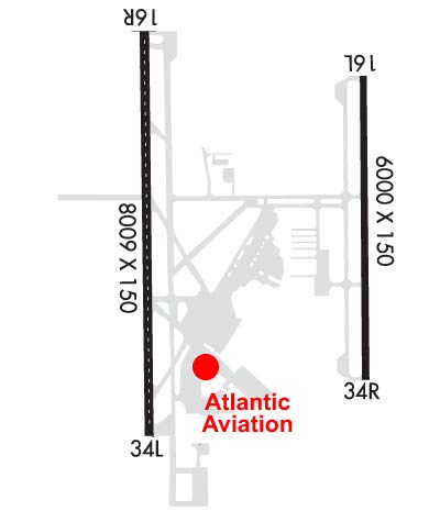
PAPI RYS 16R & 16L & 34R & VASI RY 34L OPER 24 HRS. WHEN ATCT CLSD HIRL RYS 16L/34R & 16R/34L PRE-SET MED INTST. WHEN ATCT CLSD ACTVT ALSF2 RY 16R, ODALS RY 34L, MALSR RY 16L & REIL RY 34R - CTAF.
Airport Storage AvailableTie Downs
Extra Services AvailableAir Freight, Crop Dusting, Air Ambulance, Avionics, Cargo Handling, Charter, Flight Instruction, Aircraft Rental, Aircraft Sales
Wind IndicatorYES - (lighted)
Control TowerYES
CTAF Frequency118.900
Unicom Frequency122.950
Rotating Beacon ColorWG
Segmented CircleYES
Landing FeeNO

Airport Inspection Data

Airport InspectedFEDERAL - performed by FAA AIRPORTS FIELD PERSONNEL
Inspection Date07/14/2023

Airport Services

Type of Fuel AvailableGrade 100LL, JET A (freeze point -40C)
Airframe Repair ServiceMAJOR
Power Plant Repair ServiceMAJOR

Geographic Data

LatitudeN4407.5
LongitudeW12312.7 (ESTIMATED)
Arpt Elevation373ft (SURVEYED)
Magnetic Variation15E
7 miles NWof EUGENE
Traffic Pattern Altitude800
Sectional ChartKLAMATH FALLS

Aircraft Data

Operations (Reported)YearlyAvg. Daily
General Aviation Transient 2247062
General Aviation Local 1556043
Air Taxi 1012528
Commerical 865824
Commuter 00
Military 758021
Aircraft based on Field
General Aviation Singles 88
General Aviation Multi 14
Jet Aircraft 9
General Aviation Helicopters 8
Military Aircraft 0
Gliders 0
Ultralights 0

FAA Services

FSS on field NO
FSS tie-in MC MINNVILLE
FSS Phone 1-800-WX-BRIEF
Who issues Notams EUG
Notam D service at airport YES
ARTCC Name SEATTLE

Federal Status

Airport CertificationAIRPORT RECEIVING SCHEDULED AIR CARRIER SERVICE FROM CARRIERS CERTIFICATED BY THE CIVIL AERONAUTICS BOARD; PPR FOR UNSKED ACR OPRNS WITH MORE THAN 30 PAX SEATS CALL 541-682-5430. ARFF AVBL 24 HRS A DAY, 7 DAYS A WEEK, 365 DAYS A YEAR. INDEX D AVBL WITH 24 HR PPR.
Aircraft Rescue & Firefighting IndexAIRPORT HAS A CERTIFICATE UNDER CFR PART 139
Airport of EntryNo
Custom Landing RightsNo
Joint Civil/MilitaryNo
Military Landing rightsYES

Federal Agreements

NATIONAL PLAN OF INTEGRATED AIRPORT SYSTEMS (NPIAS)
GRANT AGREEMENTS UNDER FAAP/ADAP/AIP
ASSURANCES PURSUANT TO TITLE VI, CIVIL RIGHTS ACT OF 1964
AGREEMENT UNDER DLAND OR DCLA HAS EXPIRED.

Remarks

MIGRATORY WATERFOWL & OTR BIRDS ON & INVOF ARPT.
TWYS H & K UNAVBL TO ACFT 21000 LBS SW & 40000 LBS DW GWT.
TRML APRON CLSD TO ACFT EXCP SKEDD ACRS & FLTS WITH PRIOR PMSN.
HELS LNDG AND DEPARTING AVOID OVERFLYING THE AIRLINE PSGR TRML AND RAMP LCTD E OF RY 16R/34L.
NO ACES TO RWY 34L BYD TWY A6.
FOR CD IF UNA TO CTC ON FSS FREQ, CTC SEATTLE ARTCC AT 253-351-3694.
Airport Communications & Frequencies:
ATIS Frequencies:   Hours(local) of Operation: CONTINUOUS
125.225
EUGENE Tower Frequencies:   Hours(local) of operation: 0600-2330   
118.9 ;RWY 16R/34L
124.15 ;RWY 16L/34R
371.9
EUGENE Ground Frequencies:
121.7
269.5
Clearance Delivery Frequencies:
121.7
269.5
Emergency Frequencies:
121.5
243.0
CTAF Frequency:
118.900
Unicom Frequency:
122.950
Remarks
  • APCH/DEP CTL SVC PRVDD BY SEATTLE ARTCC (ZSE) ON FREQS 125.8/291.7 (HORTON RCAG) WHEN CASCADE APCH CTL (EUG) CLSD.
  • CASCADE Primary Approach Frequencies:   Hours(local) of operation: 0600-2330   
    119.6 ;340-159
    120.25 ;160-339
    298.9 ;160-339
    348.7 ;340-159
    CASCADE Primary Departure Frequencies:   Hours(local) of operation: 0600-2330   
    119.6 ;340-159
    120.25 ;160-339
    298.9 ;160-339
    348.7 ;340-159
    Runway Identifications
    Runway Identification: 16L/34R
    Length: 6000 ft
    Width: 150 ft
    Surface: ASPHALT-GOOD CONDITION
    Edge lights: High Intensity

    Treatment: GROOVED
    Weight: PCN 60 /F/C/X/T

     Runway: 16L   Runway: 34R
    Mag heading: 164°Mag heading: 344°
    Rwy Slope: .17% UpRwy Slope: -.17% Down
    Approach: ILS/DMEApproach:
    Pattern: Left TrafficPattern: Left Traffic
    Markings: PRECISION INSTRUMENTMarkings: PRECISION INSTRUMENT
    Marking Condition: GOODMarking Condition: GOOD
    Arresting Dev: Arresting Dev:
    Lat & Long: N4408.0  W12312.2Lat. & Long.: N4407.0  W12312.1
    Elev: 363.5 ft. MSLElev: 373.6 ft. MSL
    TCH: 52 ft. AGLTCH: 50 ft. AGL
    Visual Glide Path: 3.00 degreesVisual Glide Path: 3.00 degrees
    Displaced Threshold: NoDisplaced Threshold: No
    Touchdown Zone: YESTouchdown Zone: YES
    Touchdown Elev.: 368.6 feetTouchdown Elev.: 373.7 feet
    Visual Glide Slope: 4-Light PAPI on LEFT side of RunwayVisual Glide Slope: 4-Light PAPI on LEFT side of Runway
    RVR Equipment: RVR Equipment:
    RVV Equipment: NORVV Equipment: NO
    Approach Lights: MALSR - 1,400 foot medium intensity approach lighting system with runway alignment indicator lightsApproach Lights:
    REIL: NOREIL: YES
    Centerline Lights: NOCenterline Lights: NO
    Touchdown lights: NOTouchdown lights: NO
    Runway Category: Precision Instrument RunwayRunway Category: Runway with a Non-precision Approach having visibility minimums greater than 3/4 mile
    Declared Distances: TORA:6000' TODA:6000' ASDA:6000' LDA:6000'Declared Distances: TORA:6000' TODA:6000' ASDA:6000' LDA:6000'
    Runway Identification: 16R/34L
    Length: 8009 ft
    Width: 150 ft
    Surface: ASPHALT-GOOD CONDITION
    Edge lights: High Intensity

    Treatment: GROOVED
    Weight: PCN 90 /F/C/X/T

     Runway: 16R   Runway: 34L
    Mag heading: 164°Mag heading: 344°
    Rwy Slope: .07% UpRwy Slope: -.07% Down
    Approach: ILS/DMEApproach:
    Pattern: Left TrafficPattern: Left Traffic
    Markings: PRECISION INSTRUMENTMarkings: PRECISION INSTRUMENT
    Marking Condition: GOODMarking Condition: GOOD
    Arresting Dev: Arresting Dev:
    Lat & Long: N4408.1  W12313.1Lat. & Long.: N4406.8  W12313.1
    Elev: 360.2 ft. MSLElev: 365.5 ft. MSL
    TCH: 50 ft. AGLTCH: 53 ft. AGL
    Visual Glide Path: 3.00 degreesVisual Glide Path: 3.00 degrees
    Displaced Threshold: NoDisplaced Threshold: No
    Touchdown Zone: YESTouchdown Zone: YES
    Touchdown Elev.: 363.6 feetTouchdown Elev.: 368.1 feet
    Visual Glide Slope: 4-Light PAPI on LEFT side of RunwayVisual Glide Slope: 4-BOX VASI ON LEFT SIDE OF RUNWAY
    RVR Equipment: TOUCHDOWN-MIDFIELD-ROLLOUTRVR Equipment: TOUCHDOWN-MIDFIELD-ROLLOUT
    RVV Equipment: NORVV Equipment: NO
    Approach Lights: ALSF2 - standard 2,400 foot high intensity approach lighting system with sequenced flashers, Category II or IIIApproach Lights: ODALS - omnidirectional approach lighting system
    REIL: NOREIL: NO
    Centerline Lights: YESCenterline Lights: YES
    Touchdown lights: YESTouchdown lights: NO
    Runway Category: Precision Instrument RunwayRunway Category: Runway with a Non-precision Approach having visibility minimums greater than 3/4 mile
    Declared Distances: TORA:8009' TODA:8009' ASDA:8009' LDA:8009'Declared Distances: TORA:8009' TODA:8009' ASDA:8009' LDA:8009'
    C:67/P: