Click here for more info on on SMS!

KETN

EASTLAND MUNI
EASTLAND
TX
Time Zone: Central
Lat: N 3224.9
Long: W 09848.6
Elev: 1468
Var: -07
Longest Runway: 5000
CTAF: 122.8

FBO & Flight Services info for KETN

FBOs: Update your Fuel Prices

EASTLAND AEROPh: 254-629-1588 Fax: 254-629-1125 Freq: 122.8
Service
Jet
100LL
SAF
MoGas
Fuel Avail: PRIST PREMIXED SELF SERVICE AFTER HOURS/FUEL AVAILABLE 24/7 WIFI
Full        Caution: Fuel prices have not been updated in 35 days.
Last Update: 03/22/2024 13:59

Self5.494.59    
 Address: 524 JOE BEATY RD   EASTLAND MUNI ARPT, EASTLAND, TX 76448
If you are an FBO, call 1-203-262-1700 to update your info or email: FltPlan.Advertising@garmin.com
Advertise your FBO on FltPlan.com

Runway & Approach Info for KETN
Rwy
Length
Land Dist**
Approach*
  Rwy
Length
Land Dist**
Approach*
17
5000x60  4020'          
 
  
35
  5000x60  4580'          
 
 * only ILS, LOC, LDA, and SDF approaches to a specific runway are shown
** For any Declared Landing Distance Available, please see A/FD or Approach plates
Runway Weight Capability (lbs.) Help
Runway IDSingle WheelDouble WheelDouble Tandem WheelDual Double Wheel
17/3520,000N/AN/AN/A
These numbers are Advisory and are not limits.   The Airport Manager should have more accurate Weight Limits
Approach Charts
Approaches    
Current Weather/Notams
Customs Information Send updates to Support@FltPlan.com
Customs Not Available
Database effective 05/16/2024
Airport Diagram of KETN
Airport Diagram might not be current.

Facility Name: EASTLAND MUNI
City Name: EASTLAND
County: EASTLAND
State abbrev: TX
State Name: TEXAS
   
Ownership: PUBLICLY OWNED
Use: OPEN TO THE PUBLIC
Owner's Name: CITY OF EASTLAND
Address: PO BOX 749
 EASTLAND, TX 76448
Owner's Phone: 254-629-8321
  
Manager's Name: BODE ZIETZ; MGR CELL 254-488-1055
Address: PO BOX 47
 EASTLAND, TX 76448
Phone: 254-629-1588
   
FAA Region: SOUTHWEST
FAA Field Office: TEX


Sunrise / Sunset times for EASTLAND MUNI

DateSunriseSunset
04/25/24 Thursday6:5420:13
04/26/24 Friday6:5320:13
04/27/24 Saturday6:5220:14
04/28/24 Sunday6:5120:15
04/29/24 Monday6:5020:16
04/30/24 Tuesday6:4920:16
05/01/24 Wednesday6:4820:17
05/02/24 Thursday6:4720:18
05/03/24 Friday6:4620:18
05/04/24 Saturday6:4520:19
05/05/24 Sunday6:4420:20
05/06/24 Monday6:4320:21
05/07/24 Tuesday6:4320:21
05/08/24 Wednesday6:4220:22

Airport Facilities

Airport Attendance ScheduleMON-SAT 0800-1800
Airport Status OPERATIONAL (This Status can change at any time - please check NOTAMS)
Airport Lighting ScheduleACTVT PAPI RWY 17 & 35, MIRL RWY 17/35 - CTAF.
Airport Storage AvailableTie Downs, Hanger
Extra Services AvailableFlight Instruction
Wind IndicatorYES - (lighted)
Control TowerNO
CTAF Frequency122.800
Unicom Frequency122.800
Rotating Beacon ColorWG
Segmented CircleYES
Landing FeeNO

Airport Inspection Data

Airport InspectedSTATE - performed by PRIVATE CONTRACT PERSONNEL
Inspection Date11/10/2023

Airport Services

Type of Fuel AvailableGrade 100LL, JET A (freeze point -40C); -10AFT FUEL HRS CALL 254-488-1055.
Airframe Repair ServiceMAJOR
Power Plant Repair ServiceMINOR

Geographic Data

LatitudeN3224.9
LongitudeW09848.6 (ESTIMATED)
Arpt Elevation1467ft (SURVEYED)
Magnetic Variation07E
1 miles Nof EASTLAND
Traffic Pattern Altitude
Sectional ChartDALLAS-FT WORTH

Aircraft Data

Operations (Reported)YearlyAvg. Daily
General Aviation Transient 400011
General Aviation Local 800022
Air Taxi 00
Commerical 00
Commuter 00
Military 00
Aircraft based on Field
General Aviation Singles 18
General Aviation Multi 1
Jet Aircraft 1
General Aviation Helicopters 1
Military Aircraft 0
Gliders 0
Ultralights 0

FAA Services

FSS on field NO
FSS tie-in FORT WORTH
FSS Phone 1-800-WX-BRIEF
Who issues Notams FTW
Notam D service at airport YES
ARTCC Name FORT WORTH

Federal Status

Airport Certification
Aircraft Rescue & Firefighting IndexNone
Airport of EntryNo
Custom Landing RightsNo
Joint Civil/MilitaryNo
Military Landing rightsNo

Federal Agreements

NATIONAL PLAN OF INTEGRATED AIRPORT SYSTEMS (NPIAS)

Remarks

FOR CD CTC FORT WORTH ARTCC AT 817-858-7584.
TRML AVBL 24/7 FOR FLT CREWS.
183 FT AGL, 1617 MSL UNLTD/UNMKD ANT, 1000 FM RWY 35 END, 1500 FT R.
Airport Communications & Frequencies:
CTAF Frequency:
122.800
Unicom Frequency:
122.800
Remarks
  • APCH/DEP CTL SVC PRVDD BY FORT WORTH ARTCC (ZFW) ON FREQS 127.15/314.0 (DUBLIN/B RCAG).
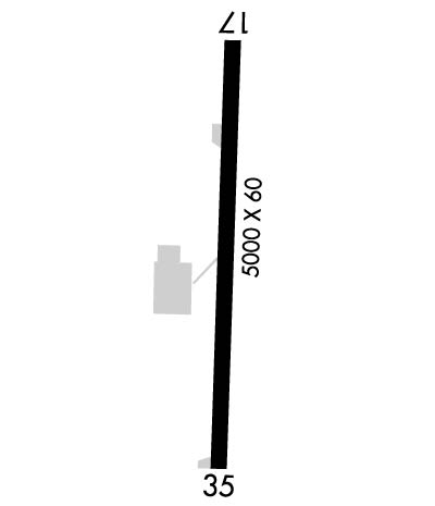
  • Runway Identifications
    Runway Identification: 17/35
    Length: 5000 ft
    Width: 60 ft
    Surface: ASPHALT-GOOD CONDITION
    Edge lights: Medium Intensity

    Treatment: NONE

     Runway: 17   Runway: 35
    Mag heading: 175°Mag heading: 355°
    Rwy Slope: -.45% DownRwy Slope: .45% Up
    Approach: Approach:
    Pattern: Left TrafficPattern: Left Traffic
    Markings: NONPRECISION INSTRUMENTMarkings: NONPRECISION INSTRUMENT
    Marking Condition: GOODMarking Condition: GOOD
    Arresting Dev: Arresting Dev:
    Lat & Long: N3225.3  W09848.6Lat. & Long.: N3224.5  W09848.6
    Elev: 1467.9 ft. MSLElev: 1445.5 ft. MSL
    TCH: 48 ft. AGLTCH: 45 ft. AGL
    Visual Glide Path: 3.50 degreesVisual Glide Path: 3.00 degrees
    Displaced Threshold: 980 feetDisplaced Threshold: 420 feet
    Touchdown Zone: YESTouchdown Zone: YES
    Touchdown Elev.: 1467.9 feetTouchdown Elev.: 1457.5 feet
    Visual Glide Slope: 2-Light PAPI on LEFT side of RunwayVisual Glide Slope: 2-Light PAPI on LEFT side of Runway
    RVR Equipment: RVR Equipment:
    RVV Equipment: NORVV Equipment: NO
    Approach Lights: Approach Lights:
    REIL: NOREIL: NO
    Centerline Lights: NOCenterline Lights: NO
    Touchdown lights: NOTouchdown lights: NO
    Runway Category: Runway with a Non-precision Approach having visibility minimums greater than 3/4 mileRunway Category: Runway with a Non-precision Approach having visibility minimums greater than 3/4 mile
    Declared Distances: Declared Distances:
    Obstructions: POLEObstructions: TREES
    Marked: LIGHTEDMarked: NOT Marked/Lighted
    Clearance slope: 14:1; APCH SLOPE 23:1 TO DSPLCD THR.Clearance slope: 22:1; APCH SLOPE 34:1 TO DSPLCD THR.
    Obstruction height: 114 feet AGL; APCH SLOPE 34:1 TO DSPLCD THR.Obstruction height: 51 feet AGL
    Dist. from runway: 1814 feetDist. from runway: 1340 feet
    Centerline offset: 33 left of centerlineCenterline offset: 370 feet right of centerline
    Comments: Comments:
    C:3/P: