Current Weather/Notams (Metars, TAFs, Notams, NWS Forecast, PIREPS, and nearby weather)
Customs Information Send updates to Support@FltPlan.com
Customs Not Available
Database effective 05/16/2024
Airport Diagram might not be current.
|
| Facility Name: | ESLER RGNL |
| City Name: | ALEXANDRIA |
| County: | RAPIDES |
| State abbrev: | LA |
| State Name: | LOUISIANA |
| | |
| Ownership: | PUBLICLY OWNED |
| Use: | OPEN TO THE PUBLIC |
| Owner's Name: | RAPIDES PARISH POLICE JURY |
| Address: | PO BOX 1150 |
| | ALEXANDRIA, LA 71309 |
| Owner's Phone: | 318-767-2536 |
| | |
| Manager's Name: | LOUIS BUSBY |
| Address: | 7625 ESLER FIELD RD |
| | PINEVILLE, LA 71360 |
| Phone: | 985-750-0485 |
| | |
| FAA Region: | SOUTHWEST |
| FAA Field Office: | LNM |
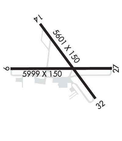
Runway Identifications
Runway Identification: 09/27Length: 5998 ft
Width: 150 ft
Surface: ASPHALT-GOOD CONDITION
Edge lights: High IntensityTreatment: GROOVED
| | Runway: 09 | | Runway: 27 |
| Mag heading: | 90° | Mag heading: | 270° |
| Rwy Slope: | -.11% Down | Rwy Slope: | .11% Up |
| Approach: | | Approach: | ILS/DME |
| Pattern: | Left Traffic | Pattern: | Left Traffic |
| Markings: | PRECISION INSTRUMENT | Markings: | PRECISION INSTRUMENT |
| Marking Condition: | GOOD | Marking Condition: | GOOD |
| Arresting Dev: | | Arresting Dev: | |
| Lat & Long: | N3123.7 W09218.4 | Lat. & Long.: | N3123.7 W09217.2 |
| Elev: | 96.2 ft. MSL | Elev: | 89.4 ft. MSL |
| TCH: | 51 ft. AGL | TCH: | |
| Visual Glide Path: | 3.00 degrees | Visual Glide Path: | |
| Displaced Threshold: | No | Displaced Threshold: | No |
| Touchdown Zone: | YES | Touchdown Zone: | YES |
| Touchdown Elev.: | 96.6 feet | Touchdown Elev.: | 91.9 feet |
| Visual Glide Slope: | 4-Light PAPI on LEFT side of Runway | Visual Glide Slope: | |
| RVR Equipment: | | RVR Equipment: | |
| RVV Equipment: | NO | RVV Equipment: | NO |
| Approach Lights: | | Approach Lights: | MALSR - 1,400 foot medium intensity approach lighting system with runway alignment indicator lights |
| REIL: | YES; RWY 09 REILS OTS | REIL: | NO |
| Centerline Lights: | NO | Centerline Lights: | NO |
| Touchdown lights: | NO | Touchdown lights: | NO |
| Runway Category: | Runway with a Non-precision Approach having visibility minimums greater than 3/4 mile | Runway Category: | Precision Instrument Runway |
| Declared Distances: | | Declared Distances: | |
| Obstructions: | TREES | Obstructions: | |
| Marked: | NOT Marked/Lighted | Marked: | |
| Clearance slope: | 35:1 | Clearance slope: | 50:1 |
| Obstruction height: | 82 feet AGL | Obstruction height: | |
| Dist. from runway: | 3080 feet | Dist. from runway: | |
| Centerline offset: | B | Centerline offset: | |
| Comments: | | Comments: | |
Runway Identification: 14/32Length: 5600 ft
Width: 150 ft
Surface: ASPHALT-FAIR CONDITION
Edge lights: Medium IntensityTreatment: GROOVED
| | Runway: 14 | | Runway: 32 |
| Mag heading: | 144° | Mag heading: | 324° |
| Rwy Slope: | -.43% Down | Rwy Slope: | .43% Up |
| Approach: | | Approach: | |
| Pattern: | Left Traffic | Pattern: | Left Traffic |
| Markings: | PRECISION INSTRUMENT | Markings: | PRECISION INSTRUMENT |
| Marking Condition: | POOR; RWY MARKINGS SEVERELY FADED | Marking Condition: | POOR; RWY MARKINGS SEVERELY FADED |
| Arresting Dev: | | Arresting Dev: | |
| Lat & Long: | N3124.1 W09218.0 | Lat. & Long.: | N3123.4 W09217.4 |
| Elev: | 111.6 ft. MSL | Elev: | 87.7 ft. MSL |
| TCH: | 36 ft. AGL | TCH: | 56 ft. AGL |
| Visual Glide Path: | 3.00 degrees | Visual Glide Path: | 3.00 degrees |
| Displaced Threshold: | No | Displaced Threshold: | No |
| Touchdown Zone: | YES | Touchdown Zone: | YES |
| Touchdown Elev.: | 111.8 feet | Touchdown Elev.: | 92.7 feet |
| Visual Glide Slope: | 4-Light PAPI on LEFT side of Runway; RWY 14 PAPI OTS | Visual Glide Slope: | 4-BOX VASI ON LEFT SIDE OF RUNWAY |
| RVR Equipment: | | RVR Equipment: | |
| RVV Equipment: | NO | RVV Equipment: | NO |
| Approach Lights: | | Approach Lights: | |
| REIL: | YES; RWY 14 REIL OTS | REIL: | YES |
| Centerline Lights: | NO | Centerline Lights: | NO |
| Touchdown lights: | NO | Touchdown lights: | NO |
| Runway Category: | Runway with a Visual Approach | Runway Category: | Runway with a Visual Approach |
| Declared Distances: | | Declared Distances: | |
| Obstructions: | TREES | Obstructions: | FENCE |
| Marked: | NOT Marked/Lighted | Marked: | NOT Marked/Lighted |
| Clearance slope: | 16:1 | Clearance slope: | |
| Obstruction height: | 116 feet AGL | Obstruction height: | 5 feet AGL |
| Dist. from runway: | 2056 feet | Dist. from runway: | 185 feet |
| Centerline offset: | 1324B | Centerline offset: | |
| Comments: | | Comments: | FENCE 100 FT 0B AND SMALL TREE 14 FT TALL 232 FT FM END OF RY. |

