Current Weather/Notams (Metars, TAFs, Notams, NWS Forecast, PIREPS, and nearby weather)
Customs Information Send updates to Support@FltPlan.com
Customs Not Available
Database effective 05/16/2024
Airport Diagram might not be current.
|
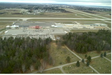
| Facility Name: | DELTA COUNTY |
| City Name: | ESCANABA |
| County: | DELTA |
| State abbrev: | MI |
| State Name: | MICHIGAN |
| | |
| Ownership: | PUBLICLY OWNED |
| Use: | OPEN TO THE PUBLIC |
| Owner's Name: | DELTA COUNTY |
| Address: | 310 LUDINGTON ST |
| | ESCANABA, MI 49829-4057 |
| Owner's Phone: | 906-789-5100 |
| | |
| Manager's Name: | ROBERT RANSTADLER |
| Address: | DELTA COUNTY AIRPORT, 3300 AIRPORT RD |
| | ESCANABA, MI 49829-1057 |
| Phone: | 906-217-7593 |
| | |
| FAA Region: | GREAT LAKES |
| FAA Field Office: | DET |
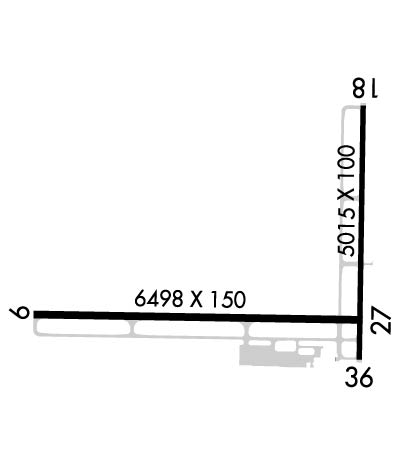
Runway Identifications
Runway Identification: 01/19Length: 5016 ft
Width: 100 ft
Surface: ASPHALT-GOOD CONDITION
Edge lights: Medium IntensityTreatment: POROUS FRICTION COURSE
Weight: PCN 79 /F/A/X/T
| | Runway: 01 | | Runway: 19 |
| Mag heading: | 6° | Mag heading: | 186° |
| Rwy Slope: | .30% Up | Rwy Slope: | -.30% Down |
| Approach: | | Approach: | |
| Pattern: | Left Traffic | Pattern: | Left Traffic |
| Markings: | NONPRECISION INSTRUMENT | Markings: | NONPRECISION INSTRUMENT |
| Marking Condition: | GOOD | Marking Condition: | GOOD |
| Arresting Dev: | | Arresting Dev: | |
| Lat & Long: | N4543.1 W08705.2 | Lat. & Long.: | N4543.9 W08705.2 |
| Elev: | 592.2 ft. MSL | Elev: | 607.0 ft. MSL |
| TCH: | 27 ft. AGL | TCH: | 42 ft. AGL |
| Visual Glide Path: | 3.00 degrees | Visual Glide Path: | 3.00 degrees |
| Displaced Threshold: | No | Displaced Threshold: | No |
| Touchdown Zone: | YES | Touchdown Zone: | YES |
| Touchdown Elev.: | 600.0 feet | Touchdown Elev.: | 607.0 feet |
| Visual Glide Slope: | 4-Light PAPI on LEFT side of Runway | Visual Glide Slope: | 4-Light PAPI on LEFT side of Runway |
| RVR Equipment: | | RVR Equipment: | |
| RVV Equipment: | NO | RVV Equipment: | NO |
| Approach Lights: | | Approach Lights: | |
| REIL: | YES | REIL: | NO |
| Centerline Lights: | NO | Centerline Lights: | NO |
| Touchdown lights: | NO | Touchdown lights: | NO |
| Runway Category: | Runway with a Non-precision Approach having visibility minimums greater than 3/4 mile | Runway Category: | Runway with a Visual Approach |
| Declared Distances: | TORA:5015' TODA:5015' ASDA:5015' LDA:5015' | Declared Distances: | TORA:5015' TODA:5015' ASDA:5015' LDA:5015' |
| Obstructions: | TREE | Obstructions: | |
| Marked: | NOT Marked/Lighted | Marked: | |
| Clearance slope: | 31:1 | Clearance slope: | 20:1 |
| Obstruction height: | 51 feet AGL | Obstruction height: | |
| Dist. from runway: | 1871 feet | Dist. from runway: | |
| Centerline offset: | 61 right of centerline | Centerline offset: | |
| Comments: | | Comments: | |
Runway Identification: 10/28Length: 6498 ft
Width: 150 ft
Surface: ASPHALT-GOOD CONDITION
Edge lights: High IntensityTreatment: POROUS FRICTION COURSE
Weight: PCN 80 /F/A/X/T
| | Runway: 10 | | Runway: 28 |
| Mag heading: | 96° | Mag heading: | 276° |
| Rwy Slope: | -.25% Down | Rwy Slope: | .25% Up |
| Approach: | ILS/DME | Approach: | |
| Pattern: | Left Traffic | Pattern: | Left Traffic |
| Markings: | PRECISION INSTRUMENT | Markings: | PRECISION INSTRUMENT |
| Marking Condition: | GOOD | Marking Condition: | GOOD |
| Arresting Dev: | | Arresting Dev: | |
| Lat & Long: | N4543.2 W08706.7 | Lat. & Long.: | N4543.2 W08705.2 |
| Elev: | 609.1 ft. MSL | Elev: | 593.1 ft. MSL |
| TCH: | | TCH: | 53 ft. AGL |
| Visual Glide Path: | | Visual Glide Path: | 3.00 degrees |
| Displaced Threshold: | No | Displaced Threshold: | No |
| Touchdown Zone: | YES | Touchdown Zone: | YES |
| Touchdown Elev.: | 609.1 feet | Touchdown Elev.: | 596.0 feet |
| Visual Glide Slope: | | Visual Glide Slope: | 4-Light PAPI on RIGHT side of Runway |
| RVR Equipment: | | RVR Equipment: | |
| RVV Equipment: | NO | RVV Equipment: | NO |
| Approach Lights: | MALSR - 1,400 foot medium intensity approach lighting system with runway alignment indicator lights | Approach Lights: | |
| REIL: | NO | REIL: | YES |
| Centerline Lights: | NO | Centerline Lights: | NO |
| Touchdown lights: | NO | Touchdown lights: | NO |
| Runway Category: | Precision Instrument Runway | Runway Category: | Runway with a Non-precision Approach having visibility minimums greater than 3/4 mile |
| Declared Distances: | TORA:6498' TODA:6498' ASDA:6498' LDA:6498' | Declared Distances: | TORA:6498' TODA:6498' ASDA:6498' LDA:6498' |