Current Weather/Notams (Metars, TAFs, Notams, NWS Forecast, PIREPS, and nearby weather)
Customs Information Send updates to Support@FltPlan.com
Phone 814-833-1355Fax 814-835-2152Comments 2 hrs advance notice required. Business hrs 0800-2200 Monday-Friday (Customs prefers arrivals by 2130 local but will accept until 2200 local). Maximum passengers per flight: 25 *Call prior to 1830 on preceding weekday for after hours service. *Call prior to 1830 on preceding Friday for any weekend service.
Database effective 05/16/2024
Airport Diagram might not be current. Facility Name: ERIE INTL/TOM RIDGE FLD City Name: ERIE County: ERIE State abbrev: PA State Name: PENNSYLVANIA Ownership: PUBLICLY OWNED Use: OPEN TO THE PUBLIC Owner's Name: ERIE REGIONAL ARPT AUTHORITY Address: 4411 W 12TH ST ERIE, PA 16505 Owner's Phone: 814-833-4258 Manager's Name: DEREK MARTIN Address: 4411 W 12TH ST ERIE, PA 16505 Phone: 814-833-4258 FAA Region: EASTERN FAA Field Office: HAR
Runway Identifications Help
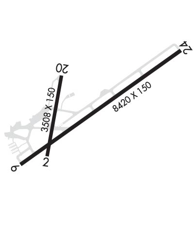
Runway Identification: 02/20 Length: 3508 ftWidth: 150 ftSurface: ASPHALT-FAIR CONDITIONEdge lights: Medium Intensity Treatment: NONE Runway: 02 Runway: 20 Mag heading: 20° Mag heading: 200° Rwy Slope: -.12% Down Rwy Slope: .12% Up Approach: Approach: Pattern: Left Traffic Pattern: Left Traffic Markings: NONPRECISION INSTRUMENT Markings: NONPRECISION INSTRUMENT Marking Condition: GOOD Marking Condition: GOOD Arresting Dev: Arresting Dev: Lat & Long: N4204.7 W08010.8 Lat. & Long.: N4205.2 W08010.7 Elev: 731.4 ft. MSL Elev: 727.3 ft. MSL TCH: TCH: 69 ft. AGL Visual Glide Path: Visual Glide Path: 4.00 degrees Displaced Threshold: 817 feet Displaced Threshold: 306 feet Touchdown Zone: YES Touchdown Zone: YES Touchdown Elev.: 730.2 feet Touchdown Elev.: 731.9 feet Visual Glide Slope: Visual Glide Slope: 4-BOX VASI ON LEFT SIDE OF RUNWAY RVR Equipment: RVR Equipment: RVV Equipment: NO RVV Equipment: NO Approach Lights: Approach Lights: REIL: NO REIL: NO Centerline Lights: NO Centerline Lights: NO Touchdown lights: NO Touchdown lights: NO Runway Category: Runway with a Visual Approach Runway Category: Runway with a Visual Approach Declared Distances: TORA:3508' TODA:3508' ASDA:3337' LDA:2520' Declared Distances: TORA:3508' TODA:3508' ASDA:3208' LDA:2902' Obstructions: RR Obstructions: ROAD Marked: LIGHTED Marked: NOT Marked/Lighted Clearance slope: APCH RATIO 22:1 TO DTHR FOR 60 FT TREES 459 FT FM RWY END 29 FT RT. Clearance slope: APCH RATIO 18:1 TO DTHR; 53 FT TREES 680 FT FM RWY END, 77 FT LEFT. Obstruction height: 31 feet AGL Obstruction height: 17 feet AGL Dist. from runway: 200 feet Dist. from runway: 200 feet Centerline offset: Centerline offset: Comments: +31 FT RR ANGLES ACROSS RWY CL +32 FT OBST LGTD POLE 106 FT FM AER 17 FT RT. Comments: +15 FT ROAD AT AER 225 FT R. +9 FT FENCE 65 FT FM RWY END 128 FT R.
Runway Identification: 06/24 Length: 8420 ftWidth: 150 ftSurface: ASPHALT-GOOD CONDITIONEdge lights: High Intensity Treatment: GROOVEDWeight: PCN 45 /F/C/X/T Runway: 06 Runway: 24 Mag heading: 64° Mag heading: 244° Rwy Slope: -.10% Down Rwy Slope: .10% Up Approach: ILS/DME Approach: ILS/DME Pattern: Left Traffic Pattern: Left Traffic Markings: PRECISION INSTRUMENT Markings: PRECISION INSTRUMENT Marking Condition: GOOD Marking Condition: GOOD Arresting Dev: Arresting Dev: Lat & Long: N4204.6 W08011.1 Lat. & Long.: N4205.4 W08009.5 Elev: 731.7 ft. MSL Elev: 723.5 ft. MSL TCH: 54 ft. AGL TCH: 55 ft. AGL Visual Glide Path: 3.00 degrees Visual Glide Path: 3.00 degrees Displaced Threshold: 919 feet Displaced Threshold: No Touchdown Zone: YES Touchdown Zone: YES Touchdown Elev.: 732.1 feet Touchdown Elev.: 729.7 feet Visual Glide Slope: 4-Light PAPI on LEFT side of Runway Visual Glide Slope: 4-Light PAPI on LEFT side of Runway RVR Equipment: TOUCHDOWN-ROLLOUT RVR Equipment: TOUCHDOWN-ROLLOUT RVV Equipment: YES RVV Equipment: YES Approach Lights: MALSR - 1,400 foot medium intensity approach lighting system with runway alignment indicator lights; MALSR UNMON. Approach Lights: MALSR - 1,400 foot medium intensity approach lighting system with runway alignment indicator lights; MALSR UNMON. REIL: NO REIL: NO Centerline Lights: NO Centerline Lights: NO Touchdown lights: NO Touchdown lights: NO Runway Category: Precision Instrument Runway Runway Category: Precision Instrument Runway Declared Distances: TORA:8420' TODA:8420' ASDA:8420' LDA:7501' Declared Distances: TORA:8420' TODA:8420' ASDA:7500' LDA:7500' Obstructions: RR Obstructions: TREES Marked: LIGHTED Marked: NOT Marked/Lighted Clearance slope: APCH RATIO 30:1 TO DTHR FOR +103 FT TREES 2227 FT FM RWY END 699 FT LEFT. Clearance slope: 12:1 Obstruction height: 31 feet AGL Obstruction height: 105 feet AGL Dist. from runway: 202 feet Dist. from runway: 1544 feet Centerline offset: 360 right of centerline Centerline offset: 698 feet right of centerline Comments: +21 FT OBST LGTD POLE AT 8 FT FROM AER 325 FT R, +15 FT BILLBOARD AT 189 FT FROM AER 327 FT R. Comments: