Click here for more info on on SMS!

KEPM

EASTPORT MUNI
EASTPORT
ME
Time Zone: Eastern
Lat: N 4454.6
Long: W 06700.8
Elev: 45
Var: +19
Longest Runway: 4002
AWOS: 122.8
CTAF: 122.8

FBO & Flight Services info for KEPM

FBOs: Update your Fuel Prices

EASTPORT MUNIPh: 207-853-2300
-
Freq: 122.8
Service
Jet
100LL
SAF
MoGas
Fuel Avail: PRIST PREMIXED Jet A N/A UFN 1/2023
Full        Last Update: 04/19/2024 14:35

Self4.846.20    
 Address: 78 HIGH STREE   EASTPORT, ME 04631
AWOSPh: 207-853-0682
-
Freq: 122.8  
If you are an FBO, call 1-203-262-1700 to update your info or email: FltPlan.Advertising@garmin.com
Advertise your FBO on FltPlan.com

Runway & Approach Info for KEPM
Rwy
Length
Land Dist**
Approach*
  Rwy
Length
Land Dist**
Approach*
15
4002x75  4002'          
 
  
33
  4002x75  4002'          
 
 * only ILS, LOC, LDA, and SDF approaches to a specific runway are shown
** For any Declared Landing Distance Available, please see A/FD or Approach plates
Runway Weight Capability (lbs.) Help
Runway IDSingle WheelDouble WheelDouble Tandem WheelDual Double Wheel
15/3330,000N/AN/AN/A
These numbers are Advisory and are not limits.   The Airport Manager should have more accurate Weight Limits
Approach Charts
Approaches    
Current Weather/Notams
Customs Information Send updates to Support@FltPlan.com
Phone 207-853-4313
Fax 207-853-4313

Comments Mon-Sat 0800-1600 *3 hr advance notice required *Maximum passengers per flight: 10
Database effective 05/16/2024
Airport Diagram of KEPM
Airport Diagram might not be current.

Facility Name: EASTPORT MUNI
City Name: EASTPORT
County: WASHINGTON
State abbrev: ME
State Name: MAINE
   
Ownership: PUBLICLY OWNED
Use: OPEN TO THE PUBLIC
Owner's Name: CITY OF EASTPORT
Address: 22 WASHINGTON ST
 EASTPORT, ME 04631
Owner's Phone: 207-853-2300
  
Manager's Name: PETE LEHMANN
Address: 1 AIRPORT RD
 EASTPORT, ME 04631
Phone: 207-214-4751
   
FAA Region: NEW ENGLAND
FAA Field Office: NONE


Sunrise / Sunset times for EASTPORT MUNI

DateSunriseSunset
04/24/24 Wednesday5:2719:26
04/25/24 Thursday5:2619:27
04/26/24 Friday5:2419:28
04/27/24 Saturday5:2319:29
04/28/24 Sunday5:2119:31
04/29/24 Monday5:1919:32
04/30/24 Tuesday5:1819:33
05/01/24 Wednesday5:1719:34
05/02/24 Thursday5:1519:36
05/03/24 Friday5:1419:37
05/04/24 Saturday5:1219:38
05/05/24 Sunday5:1119:39
05/06/24 Monday5:0919:40
05/07/24 Tuesday5:0819:42

Airport Facilities

Airport Attendance ScheduleUNATTENDED
Airport Status OPERATIONAL (This Status can change at any time - please check NOTAMS)
Airport Lighting ScheduleACTVT REIL RWY 15 & 33; PAPI RWY 33; MIRL RWY 15/33 - CTAF.
Airport Storage AvailableTie Downs
Extra Services AvailableNONE
Wind IndicatorYES - (lighted)
Control TowerNO
CTAF Frequency122.800
Unicom Frequency122.800
Rotating Beacon ColorWG
Segmented CircleNO
Landing FeeNO

Airport Inspection Data

Airport InspectedSTATE - performed by PRIVATE CONTRACT PERSONNEL
Inspection Date08/21/2023

Airport Services

Type of Fuel AvailableGrade 100LL, JET A
Airframe Repair ServiceMAJOR
Power Plant Repair ServiceMAJOR

Geographic Data

LatitudeN4454.6
LongitudeW06700.8 (ESTIMATED)
Arpt Elevation45ft (SURVEYED)
Magnetic Variation19W
1 miles Wof EASTPORT
Traffic Pattern Altitude
Sectional ChartHALIFAX

Aircraft Data

Operations (Reported)YearlyAvg. Daily
General Aviation Transient 18005
General Aviation Local 27007
Air Taxi 00
Commerical 00
Commuter 00
Military 15004
Aircraft based on Field
General Aviation Singles 7
General Aviation Multi 0
Jet Aircraft 0
General Aviation Helicopters 0
Military Aircraft 0
Gliders 0
Ultralights 0

FAA Services

FSS on field NO
FSS tie-in BANGOR
FSS Phone 1-800-WX-BRIEF
Who issues Notams EPM
Notam D service at airport YES
ARTCC Name BOSTON

Federal Status

Airport Certification
Aircraft Rescue & Firefighting IndexNone
Airport of EntryNo
Custom Landing RightsYES
Joint Civil/MilitaryNo
Military Landing rightsYES

Federal Agreements

NATIONAL PLAN OF INTEGRATED AIRPORT SYSTEMS (NPIAS)
GRANT AGREEMENT HAS EXPIRED; HOWEVER, AGREEMENT REMAINS IN EFFECT FOR THIS FACILITY AS LONG AS IT IS PUBLIC USE.
AGREEMENT UNDER DLAND OR DCLA HAS EXPIRED.

Remarks

DEER & NMRS BIRDS ON & INVOF RWY.
REQ CUST AT 207-853-4313.
24 HR SELF-SVC FUEL AVBL WITH CREDIT CARD.
40-50 FT OBSTN LGTS ON POLES 250 FT R OF CNTRLN NEAR RWY 15 END & APCH AREA.
FOR CD CTC BOSTON ARTCC AT 603-879-6859.
JET-A FUEL PUMP LMTD TO OVR WING GRAVITY RFLG OPS.
Airport Communications & Frequencies:
CTAF Frequency:
122.800
Unicom Frequency:
122.800
Remarks
  • APCH/DEP SVC PRVDD BY BOSTON ARTCC ON FREQ 124.25/290.50 (BANGOR RCAG).
  • Runway Identifications
    Runway Identification: 15/33
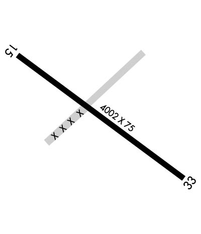
    Length: 4002 ft
    Width: 75 ft
    Surface: ASPHALT-GOOD CONDITION
    Edge lights: Medium Intensity

    Treatment: NONE

     Runway: 15   Runway: 33
    Mag heading: 146°Mag heading: 326°
    Rwy Slope: .26% UpRwy Slope: -.26% Down
    Approach: Approach:
    Pattern: Left TrafficPattern: Left Traffic
    Markings: NONPRECISION INSTRUMENTMarkings: NONPRECISION INSTRUMENT
    Marking Condition: GOODMarking Condition: GOOD
    Arresting Dev: Arresting Dev:
    Lat & Long: N4454.8  W06701.1Lat. & Long.: N4454.4  W06700.4
    Elev: 34.6 ft. MSLElev: 45.2 ft. MSL
    TCH: TCH: 44 ft. AGL
    Visual Glide Path: Visual Glide Path: 3.28 degrees
    Displaced Threshold: NoDisplaced Threshold: No
    Touchdown Zone: YESTouchdown Zone: YES
    Touchdown Elev.: 43.8 feetTouchdown Elev.: 45.3 feet
    Visual Glide Slope: Visual Glide Slope: 2-Light PAPI on LEFT side of Runway
    RVR Equipment: RVR Equipment:
    RVV Equipment: NORVV Equipment: NO
    Approach Lights: Approach Lights:
    REIL: YESREIL: YES
    Centerline Lights: NOCenterline Lights: NO
    Touchdown lights: NOTouchdown lights: NO
    Runway Category: Runway with a Non-precision ApproachRunway Category: Runway with a Non-precision Approach
    Declared Distances: Declared Distances:
    Obstructions: TREEObstructions:
    Marked: LIGHTEDMarked:
    Clearance slope: CTLG OBSTN EXCEEDS A 45 DEG SLP.Clearance slope: 20:1
    Obstruction height: 12 feet AGLObstruction height:
    Dist. from runway: 205 feetDist. from runway:
    Centerline offset: 75 left of centerlineCenterline offset:
    Comments: 3-5 FT BRUSH 20-200 FT FM THR, 100-200 FT R OF CNTRLN; 8 FT BERM 0-125 FT FM THR, 190 FT R OF CNTRLNE; 6-8 FT BRUSH, 100-200 FT FM THR, 65-200 FT L CNTRLN.Comments: 3-9 FT WEEDS AND GRASS 100-200 FT FM THR, 75-250 FT R OF CNTRLN; 2-5 FT RISING TERRAIN 50-120 FT FM THR, 125 FT L OF CNTRLN.
    C:1/P: