Current Weather/Notams (Metars, TAFs, Notams, NWS Forecast, PIREPS, and nearby weather)
Customs Information Send updates to Support@FltPlan.com
Customs Not Available
Database effective 04/18/2024
Airport Diagram might not be current.
|
| Facility Name: | EPHRATA MUNI |
| City Name: | EPHRATA |
| County: | GRANT |
| State abbrev: | WA |
| State Name: | WASHINGTON |
| | |
| Ownership: | PUBLICLY OWNED |
| Use: | OPEN TO THE PUBLIC |
| Owner's Name: | PORT DIST NO 9 GRANT CO |
| Address: | PORT OF EPHRATA PO BOX 1089 |
| | EPHRATA, WA 98823 |
| Owner's Phone: | 509-754-3508 |
| | |
| Manager's Name: | DAVID LANMAN |
| Address: | PO BOX 1089 |
| | EPHRATA, WA 98823 |
| Phone: | 509-754-3508 |
| | |
| FAA Region: | NORTHWEST MOUNTAIN |
| FAA Field Office: | SEA |
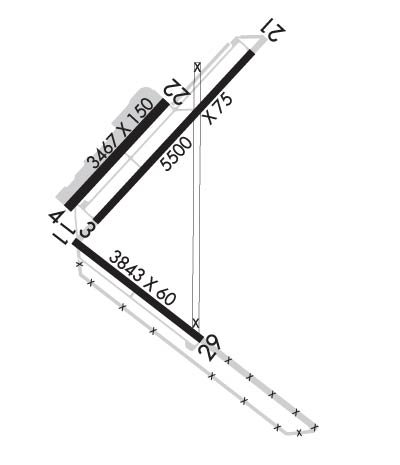
Runway Identifications
Runway Identification: 03/21Length: 5500 ft
Width: 75 ft
Surface: ASPHALT-GOOD CONDITION
Edge lights: Medium IntensityTreatment: NONE
| | Runway: 03 | | Runway: 21 |
| Mag heading: | 27° | Mag heading: | 207° |
| Rwy Slope: | .26% Up | Rwy Slope: | -.26% Down |
| Approach: | | Approach: | |
| Pattern: | Right Traffic | Pattern: | Left Traffic |
| Markings: | NONPRECISION INSTRUMENT | Markings: | NONPRECISION INSTRUMENT |
| Marking Condition: | GOOD | Marking Condition: | GOOD |
| Arresting Dev: | | Arresting Dev: | |
| Lat & Long: | N4718.4 W11931.3 | Lat. & Long.: | N4719.0 W11930.4 |
| Elev: | 1261.4 ft. MSL | Elev: | 1275.5 ft. MSL |
| TCH: | 40 ft. AGL | TCH: | 40 ft. AGL |
| Visual Glide Path: | 3.00 degrees | Visual Glide Path: | 3.00 degrees |
| Displaced Threshold: | No | Displaced Threshold: | No |
| Touchdown Zone: | YES | Touchdown Zone: | YES |
| Touchdown Elev.: | 1269.2 feet | Touchdown Elev.: | 1276.2 feet |
| Visual Glide Slope: | 4-Light PAPI on LEFT side of Runway | Visual Glide Slope: | 4-Light PAPI on LEFT side of Runway |
| RVR Equipment: | | RVR Equipment: | |
| RVV Equipment: | NO | RVV Equipment: | NO |
| Approach Lights: | | Approach Lights: | |
| REIL: | YES | REIL: | YES |
| Centerline Lights: | NO | Centerline Lights: | NO |
| Touchdown lights: | NO | Touchdown lights: | NO |
| Runway Category: | Runway with a Non-precision Approach having visibility minimums greater than 3/4 mile | Runway Category: | Runway with a Non-precision Approach having visibility minimums greater than 3/4 mile |
| Declared Distances: | | Declared Distances: | |
| Obstructions: | GND | Obstructions: | |
| Marked: | NOT Marked/Lighted | Marked: | |
| Clearance slope: | 38:1 | Clearance slope: | 50:1 |
| Obstruction height: | 58 feet AGL | Obstruction height: | |
| Dist. from runway: | 2450 feet | Dist. from runway: | |
| Centerline offset: | 550 left of centerline | Centerline offset: | |
| Comments: | | Comments: | |
Runway Identification: 04/22Length: 3467 ft
Width: 150 ft
Surface: ASPHALT-FAIR CONDITION
Edge lights: Treatment: NONE
| | Runway: 04 | | Runway: 22 |
| Mag heading: | 26° | Mag heading: | 206° |
| Rwy Slope: | .02% Up | Rwy Slope: | -.02% Down |
| Approach: | | Approach: | |
| Pattern: | Left Traffic | Pattern: | Right Traffic |
| Markings: | NONE | Markings: | NONE |
| Marking Condition: | FAIR | Marking Condition: | FAIR |
| Arresting Dev: | | Arresting Dev: | |
| Lat & Long: | N4718.4 W11931.5 | Lat. & Long.: | N4718.8 W11930.9 |
| Elev: | 1260.9 ft. MSL | Elev: | 1261.5 ft. MSL |
| TCH: | | TCH: | |
| Visual Glide Path: | | Visual Glide Path: | |
| Displaced Threshold: | No | Displaced Threshold: | No |
| Touchdown Zone: | NO | Touchdown Zone: | NO |
| Touchdown Elev.: | | Touchdown Elev.: | |
| Visual Glide Slope: | | Visual Glide Slope: | |
| RVR Equipment: | | RVR Equipment: | |
| RVV Equipment: | NO | RVV Equipment: | NO |
| Approach Lights: | | Approach Lights: | |
| REIL: | NO | REIL: | NO |
| Centerline Lights: | NO | Centerline Lights: | NO |
| Touchdown lights: | NO | Touchdown lights: | NO |
| Runway Category: | Runway with a Visual Approach | Runway Category: | Runway with a Visual Approach |
| Declared Distances: | | Declared Distances: | |
Runway Identification: 11/29Length: 3843 ft
Width: 60 ft
Surface: ASPHALT-GOOD CONDITION
Edge lights: Medium IntensityTreatment: NONE
| | Runway: 11 | | Runway: 29 |
| Mag heading: | 112° | Mag heading: | 292° |
| Rwy Slope: | -.10% Down | Rwy Slope: | .10% Up |
| Approach: | | Approach: | |
| Pattern: | Left Traffic | Pattern: | Left Traffic |
| Markings: | BASIC | Markings: | BASIC |
| Marking Condition: | GOOD | Marking Condition: | GOOD |
| Arresting Dev: | | Arresting Dev: | |
| Lat & Long: | N4718.3 W11931.4 | Lat. & Long.: | N4717.9 W11930.7 |
| Elev: | 1261.3 ft. MSL | Elev: | 1257.3 ft. MSL |
| TCH: | | TCH: | 40 ft. AGL |
| Visual Glide Path: | | Visual Glide Path: | 3.00 degrees |
| Displaced Threshold: | No | Displaced Threshold: | No |
| Touchdown Zone: | YES | Touchdown Zone: | YES |
| Touchdown Elev.: | 1263.0 feet | Touchdown Elev.: | 1263.0 feet |
| Visual Glide Slope: | | Visual Glide Slope: | 2-Light PAPI on LEFT side of Runway |
| RVR Equipment: | | RVR Equipment: | |
| RVV Equipment: | NO | RVV Equipment: | NO |
| Approach Lights: | | Approach Lights: | |
| REIL: | YES | REIL: | YES |
| Centerline Lights: | NO | Centerline Lights: | NO |
| Touchdown lights: | NO | Touchdown lights: | NO |
| Runway Category: | Runway with a Visual Approach | Runway Category: | Runway with a Visual Approach |
| Declared Distances: | | Declared Distances: | |
| Obstructions: | GND | Obstructions: | |
| Marked: | NOT Marked/Lighted | Marked: | |
| Clearance slope: | 28:1 | Clearance slope: | 50:1 |
| Obstruction height: | 52 feet AGL | Obstruction height: | |
| Dist. from runway: | 1666 feet | Dist. from runway: | |
| Centerline offset: | 293 left of centerline | Centerline offset: | |
| Comments: | | Comments: | |

