Click here for more info on on SMS!

KEOE

NEWBERRY COUNTY
NEWBERRY
SC
Time Zone: Eastern
Lat: N 3418.6
Long: W 08138.4
Elev: 570
Var: +07
Longest Runway: 4001
AWOS: 124.27
CTAF: 122.8

FBO & Flight Services info for KEOE

FBOs: Update your Fuel Prices
Providing high quality fuel and services to you and your customers, from Phillips 66 Aviation.
Ph: 803-321-2180
-
-
WebsiteE-Mail
Service
Jet
100LL
SAF
MoGas
Full        Caution: Fuel prices have not been updated in 57 days.
Last Update: 02/26/2024 13:50

Self  6.14    
Misc. Info: Address: PO BOX 156 1309 COLLEGE STREET   NEWBERRY, SC 29108

CLAMPS AERO SVCPh: 803-321-9046
-
Freq: 122.8
Service
Jet
100LL
SAF
MoGas
Fuel Avail: ~~MAINT ONLY
Full        Last Update: 04/23/2024 05:40:07  
Self        
AWOSPh: 803-276-2419
-
Freq: 124.27  
If you are an FBO, call 1-203-262-1700 to update your info or email: FltPlan.Advertising@garmin.com
Advertise your FBO on FltPlan.com

Runway & Approach Info for KEOE
Rwy
Length
Land Dist**
Approach*
  Rwy
Length
Land Dist**
Approach*
04
4001x75  4001'          
 
  
22
  4001x75  4001'          
 
 * only ILS, LOC, LDA, and SDF approaches to a specific runway are shown
** For any Declared Landing Distance Available, please see A/FD or Approach plates
Runway Weight Capability (lbs.) Help
Runway IDSingle WheelDouble WheelDouble Tandem WheelDual Double Wheel
04/2223,00030,000N/AN/A
These numbers are Advisory and are not limits.   The Airport Manager should have more accurate Weight Limits
Approach Charts
Approaches    
Current Weather/Notams
Customs Information Send updates to Support@FltPlan.com
Customs Not Available
Database effective 05/16/2024
Airport Diagram of KEOE
Airport Diagram might not be current.

Facility Name: NEWBERRY COUNTY
City Name: NEWBERRY
County: NEWBERRY
State abbrev: SC
State Name: SOUTH CAROLINA
   
Ownership: PUBLICLY OWNED
Use: OPEN TO THE PUBLIC
Owner's Name: NEWBERRY COUNTY
Address: PO BOX 156
 NEWBERRY, SC 29108
Owner's Phone: 803-321-2100
  
Manager's Name: MIKE PISANO; PUBLIC WORKS DIRECTOR
Address: P.O. BOX 156, 1309 COLLEGE STREET
 NEWBERRY, SC 29108
Phone: (803) 944-4298; (803) 321-2383 FAX.
   
FAA Region: SOUTHERN
FAA Field Office: ATL


Sunrise / Sunset times for NEWBERRY COUNTY

DateSunriseSunset
04/22/24 Monday6:4620:04
04/23/24 Tuesday6:4520:05
04/24/24 Wednesday6:4420:06
04/25/24 Thursday6:4320:07
04/26/24 Friday6:4120:08
04/27/24 Saturday6:4020:08
04/28/24 Sunday6:3920:09
04/29/24 Monday6:3820:10
04/30/24 Tuesday6:3720:11
05/01/24 Wednesday6:3620:11
05/02/24 Thursday6:3520:12
05/03/24 Friday6:3420:13
05/04/24 Saturday6:3320:14
05/05/24 Sunday6:3220:15

Airport Facilities

Airport Attendance ScheduleUNATTENDED
Airport Status OPERATIONAL (This Status can change at any time - please check NOTAMS)
Airport Lighting ScheduleACTIVATE - PAPI, MIRL RY 04/22 - CTAF.
Airport Storage AvailableTie Downs
Extra Services AvailableFlight Instruction
Wind IndicatorYES - (lighted)
Control TowerNO
CTAF Frequency122.800
Unicom Frequency122.800
Rotating Beacon ColorWG
Segmented CircleYES
Landing FeeNO

Airport Inspection Data

Airport InspectedSTATE - performed by STATE AERONAUTICAL PERSONNEL
Inspection Date06/13/2023

Airport Services

Type of Fuel AvailableGrade 100LL; -10SELF-SERVE.
Airframe Repair ServiceMAJOR
Power Plant Repair ServiceMAJOR

Geographic Data

LatitudeN3418.6
LongitudeW08138.4 (ESTIMATED)
Arpt Elevation570ft (SURVEYED)
Magnetic Variation07W
3 miles Nof NEWBERRY
Traffic Pattern Altitude
Sectional ChartCHARLOTTE

Aircraft Data

Operations (Reported)YearlyAvg. Daily
General Aviation Transient 21106
General Aviation Local 17585
Air Taxi 1320
Commerical 00
Commuter 00
Military 1000
Aircraft based on Field
General Aviation Singles 14
General Aviation Multi 2
Jet Aircraft 0
General Aviation Helicopters 0
Military Aircraft 0
Gliders 0
Ultralights 0

FAA Services

FSS on field NO
FSS tie-in ANDERSON
FSS Phone 1-800-WX-BRIEF
Who issues Notams AND
Notam D service at airport YES
ARTCC Name ATLANTA

Federal Status

Airport Certification
Aircraft Rescue & Firefighting IndexNone
Airport of EntryNo
Custom Landing RightsNo
Joint Civil/MilitaryNo
Military Landing rightsYES

Federal Agreements

NATIONAL PLAN OF INTEGRATED AIRPORT SYSTEMS (NPIAS)
ASSURANCES PURSUANT TO TITLE VI, CIVIL RIGHTS ACT OF 1964
GRANT AGREEMENT HAS EXPIRED; HOWEVER, AGREEMENT REMAINS IN EFFECT FOR THIS FACILITY AS LONG AS IT IS PUBLIC USE.

Remarks

DEER ON & INVOF ARPT.
FOR CD CTC COLUMBIA APCH AT 803-822-4511.
Airport Communications & Frequencies:
CTAF Frequency:
122.800
Unicom Frequency:
122.800
COLUMBIA Primary Approach Frequencies:  
133.4
285.6
COLUMBIA Primary Departure Frequencies:  
133.4
285.6
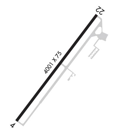
Runway Identifications
Runway Identification: 04/22
Length: 4001 ft
Width: 75 ft
Surface: ASPHALT
Edge lights: Medium Intensity

Treatment: AGGREGATE FRICTION SEAL COAT

 Runway: 04   Runway: 22
Mag heading: 44°Mag heading: 224°
Rwy Slope: .86% UpRwy Slope: -.86% Down
Approach: Approach:
Pattern: Left TrafficPattern: Right Traffic
Markings: NONPRECISION INSTRUMENTMarkings: NONPRECISION INSTRUMENT
Marking Condition: GOODMarking Condition: GOOD
Arresting Dev: Arresting Dev:
Lat & Long: N3418.3  W08138.7Lat. & Long.: N3418.8  W08138.2
Elev: 535.6 ft. MSLElev: 570.1 ft. MSL
TCH: 42 ft. AGLTCH: 43 ft. AGL
Visual Glide Path: 3.15 degreesVisual Glide Path: 3.15 degrees
Displaced Threshold: NoDisplaced Threshold: No
Touchdown Zone: YESTouchdown Zone: YES
Touchdown Elev.: 557.6 feetTouchdown Elev.: 570.1 feet
Visual Glide Slope: 2-Light PAPI on LEFT side of RunwayVisual Glide Slope: 2-Light PAPI on LEFT side of Runway
RVR Equipment: RVR Equipment:
RVV Equipment: NORVV Equipment: NO
Approach Lights: Approach Lights:
REIL: NOREIL: NO
Centerline Lights: NOCenterline Lights: NO
Touchdown lights: NOTouchdown lights: NO
Runway Category: Runway with a Non-precision Approach having visibility minimums greater than 3/4 mileRunway Category: Runway with a Non-precision Approach having visibility minimums greater than 3/4 mile
Declared Distances: Declared Distances:
Obstructions: TREESObstructions: POLE
Marked: NOT Marked/LightedMarked: NOT Marked/Lighted
Clearance slope: 22:1Clearance slope: 24:1
Obstruction height: 96 feet AGLObstruction height: 34 feet AGL
Dist. from runway: 2379 feetDist. from runway: 1025 feet
Centerline offset: 271 right of centerlineCenterline offset: 191 feet left of centerline
Comments: Comments:
C:1/P: