KENW

KENOSHA RGNL
KENOSHA
WI
Time Zone: Central
Lat: N 4235.8
Long: W 08755.6
Elev: 743
Var: +02
Longest Runway: 6600
Clr Del: 118.6
Dept. ATIS: 127.17
Arr. ATIS: 127.17
AWOS: 127.17
Ground: 121.87
Tower: 118.6

FBO & Flight Services info for KENW

FBOs: Update your Fuel Prices
Just 2 minutes from Interstate I-94 between Chicago and Milwaukee! Lowest Jet A price in the area!
Monday- Friday 6:30am till 9:00pm Saturday- Sunday 7-7
Avfuel and Avfuel Contract Fuel, Avtrip Volume Discounts. Hangar through G-V. Courtesy Cars, WI-FI, Shower, Lounge, WX
Ph: 262-605-0474 Fax: 262-605-9522 Freq: 122.85WebsiteE-Mail
                   
Service
Jet
100LL
SAF
MoGas
Fuel Avail: Prices inc. tax. PRIST PREMIXED. HRS 6:30A-9P, M-SUN
Full4.706.39    Last Update: 04/02/2024 13:25

Volume Discounts on JetA
Self  5.91    
Misc. Info: volume discount/contract fuel. 100LL self serve pump is located on the south east side of the terminAddress: 9420 52ND. ST.,   KENOSHA, WI 53144

  click here  
NOW OPEN! Aviation fuel, FAA-licensed AC repair station, ground handling, oxygen service, aircraft parking, hangar availability, GPU/power cart, passenger terminal & lounge, AC maintenance plus rentals/leasing/brokerage/management, catering, rental cars, courtesy transportation, courtesy cars (free for pilots' local use), pilots lounge/snooze room, internet, restrooms & showers, U.S. Customs.
Ph: 262-597-1087
-
Freq: 130.55WebsiteE-Mail
                               
Service
Jet
100LL
SAF
MoGas
Fuel Avail: Jet A w/ additive Hrs 7a-9p, M-Sunday. After hours by appointment.
Full4.70      Last Update: 04/23/2024 08:42
PRICES GUARANTEED by FBO.
Self        
Misc. Info: Zero Ramp and Landing FeesAddress: 4222 91ST AVENUE   KENOSHA, WI 53144

ASOSPh: 262-652-7730
-
Freq: 127.17  
If you are an FBO, call 1-203-262-1700 to update your info or email: FltPlan.Advertising@garmin.com
Advertise your FBO on FltPlan.com

Runway & Approach Info for KENW
Rwy
Length
Land Dist**
Approach*
  Rwy
Length
Land Dist**
Approach*
07L
6600x100  6600'          
ILS
 109.35 - 067°  
  
25R
  6600x100  6600'          
 
07R
3302x75  3302'          
 
  
25L
  3302x75  3302'          
 
15
4440x100  4440'          
 
  
33
  4440x100  4440'          
 
 * only ILS, LOC, LDA, and SDF approaches to a specific runway are shown
** For any Declared Landing Distance Available, please see A/FD or Approach plates
Runway Weight Capability (lbs.) Help
Runway IDSingle WheelDouble WheelDouble Tandem WheelDual Double Wheel
07L/25R62,00073,000135,000N/A
07R/25L40,00048,000N/AN/A
15/3362,00073,000135,000N/A
These numbers are Advisory and are not limits.   The Airport Manager should have more accurate Weight Limits
Approach Charts
Approaches    
Current Weather/Notams
Customs Information Send updates to Support@FltPlan.com
Phone 262-633-0286
Fax N/A

Comments 2 hrs advance notice required. Business hrs 0830-1630 Monday-Friday. *Maximum passengers per flight: 15 *M-F Call prior to 1730 on preceding weekday. *WKND Call prior to 1730 on preceding Friday
Database effective 05/16/2024
Airport Diagram of KENW
Airport Diagram might not be current.

Facility Name: KENOSHA RGNL
City Name: KENOSHA
County: KENOSHA
State abbrev: WI
State Name: WISCONSIN
   
Ownership: PUBLICLY OWNED
Use: OPEN TO THE PUBLIC
Owner's Name: CITY OF KENOSHA
Address: 625 52ND ST
 KENOSHA, WI 53140
Owner's Phone: (262) 653-4159
  
Manager's Name: COREY REED
Address: 9900 52ND ST
 KENOSHA, WI 53144
Phone: 262-653-4161
   
FAA Region: GREAT LAKES
FAA Field Office: CHI


Sunrise / Sunset times for KENOSHA RGNL

DateSunriseSunset
04/25/24 Thursday5:5419:46
04/26/24 Friday5:5219:47
04/27/24 Saturday5:5119:48
04/28/24 Sunday5:4919:49
04/29/24 Monday5:4819:50
04/30/24 Tuesday5:4719:52
05/01/24 Wednesday5:4519:53
05/02/24 Thursday5:4419:54
05/03/24 Friday5:4319:55
05/04/24 Saturday5:4119:56
05/05/24 Sunday5:4019:57
05/06/24 Monday5:3919:58
05/07/24 Tuesday5:3819:59
05/08/24 Wednesday5:3620:00

Airport Facilities

Airport Attendance Schedule7 Days A Week 0700-2100
Airport Status OPERATIONAL (This Status can change at any time - please check NOTAMS)
Airport Lighting ScheduleWHEN ATCT CLSD, HIRL RWY 07L/25R PRESET ON LOW INTST; TO INCR INTST & ACTVT MALSR RWY 07L; REIL RWY 25R; PAPI RWY 07L, 07R, 25L & 25R; HIRL RWY 07L/25R; HIRL RWY 15/33; MIRL RWY 07R/25L - CTAF. VASI RWY 15 & 33 OPRS CONSLY.
Airport Storage AvailableTie Downs, Hanger
Extra Services AvailableAvionics, Cargo Handling, Charter, Flight Instruction, Aircraft Rental, Aircraft Sales
Wind IndicatorYES - (unlit)
Control TowerYES
CTAF Frequency118.600
Unicom Frequency122.950
Rotating Beacon ColorWG
Segmented CircleYES
Landing FeeNO

Airport Inspection Data

Airport InspectedFEDERAL - performed by STATE AERONAUTICAL PERSONNEL
Inspection Date06/02/2022

Airport Services

Type of Fuel AvailableGrade 100LL, JET A (freeze point -40C)
Airframe Repair ServiceMAJOR
Power Plant Repair ServiceMAJOR

Geographic Data

LatitudeN4235.8
LongitudeW08755.6 (ESTIMATED)
Arpt Elevation742ft (SURVEYED)
Magnetic Variation02W
4 miles Wof KENOSHA
Traffic Pattern Altitude
Sectional ChartCHICAGO

Aircraft Data

Operations (Reported)YearlyAvg. Daily
General Aviation Transient 2487568
General Aviation Local 3057584
Air Taxi 445712
Commerical 570
Commuter 00
Military 340
Aircraft based on Field
General Aviation Singles 173
General Aviation Multi 20
Jet Aircraft 17
General Aviation Helicopters 12
Military Aircraft 0
Gliders 1
Ultralights 0

FAA Services

FSS on field NO
FSS tie-in GREEN BAY
FSS Phone 1-800-WX-BRIEF
Who issues Notams ENW
Notam D service at airport YES
ARTCC Name CHICAGO

Federal Status

Airport Certification
Aircraft Rescue & Firefighting IndexNone
Airport of EntryNo
Custom Landing RightsNo
Joint Civil/MilitaryNo
Military Landing rightsYES

Federal Agreements

NATIONAL PLAN OF INTEGRATED AIRPORT SYSTEMS (NPIAS)
GRANT AGREEMENTS UNDER FAAP/ADAP/AIP
ASSURANCES PURSUANT TO TITLE VI, CIVIL RIGHTS ACT OF 1964

Remarks

BIRDS ON & INVOF ARPT.
HELICOPTER DEP & ARR OPS WILL BE AUTH BY ATC FM MOVEMENT AREAS ONLY. NON-MOVEMENT AREA DEPS, ARRS & PRACTICE, ARE PROHIBITED.
ACFT WEIGHING MORE THAN 122,000 LBS, EMPTY OR FULLY LOADED, ARE NOT ALLOWED TO BE BASED AT KENW. THE TERM BASED SHALL BE DEFINED AS AN ACFT THAT IS OPR & AIRWORTHY ON THE ARPT FOR A MAJORITY OF THE YEAR.
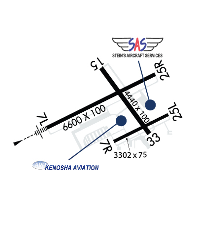
RWY 07R/ 25LCLSD TO JET ACFT & ACFT WEIGHING MORE THAN 12500 LBS WHEN RWY 07L/25R IS OPEN.
Airport Communications & Frequencies:
ATIS Frequencies:   Hours(local) of Operation: CONTINUOUS
127.175
KENOSHA Tower Frequencies:   Hours(local) of operation: 0700-2100   
118.6
353.6
KENOSHA Ground Frequencies:
121.875
Clearance Delivery Frequencies:
121.875
118.6 WHEN TWR CLSD
CTAF Frequency:
118.600
Unicom Frequency:
122.950
Remarks
  • ATCT OPERATED BY MIDWEST AVIATION.
  • MILWAUKEE Primary Approach Frequencies:  
    135.875
    317.725
    MILWAUKEE Primary Departure Frequencies:  
    135.875
    317.725
    Runway Identifications
    Runway Identification: 07L/25R
    Length: 6600 ft
    Width: 100 ft
    Surface: CONCRETE
    Edge lights: High Intensity

    Treatment: GROOVED

     Runway: 07L   Runway: 25R
    Mag heading: 66°Mag heading: 246°
    Rwy Slope: -.54% DownRwy Slope: .54% Up
    Approach: ILSApproach:
    Pattern: Left TrafficPattern: Right Traffic
    Markings: PRECISION INSTRUMENTMarkings: PRECISION INSTRUMENT
    Marking Condition: GOODMarking Condition: GOOD
    Arresting Dev: Arresting Dev:
    Lat & Long: N4235.6  W08756.5Lat. & Long.: N4236.1  W08755.2
    Elev: 742.6 ft. MSLElev: 707.2 ft. MSL
    TCH: 55 ft. AGLTCH: 45 ft. AGL
    Visual Glide Path: 3.00 degreesVisual Glide Path: 3.00 degrees
    Displaced Threshold: NoDisplaced Threshold: No
    Touchdown Zone: YESTouchdown Zone: YES
    Touchdown Elev.: 742.6 feetTouchdown Elev.: 723.0 feet
    Visual Glide Slope: 4-Light PAPI on LEFT side of RunwayVisual Glide Slope: 4-Light PAPI on LEFT side of Runway
    RVR Equipment: RVR Equipment:
    RVV Equipment: NORVV Equipment: NO
    Approach Lights: MALSR - 1,400 foot medium intensity approach lighting system with runway alignment indicator lightsApproach Lights:
    REIL: NOREIL: YES
    Centerline Lights: NOCenterline Lights: NO
    Touchdown lights: NOTouchdown lights: NO
    Runway Category: Precision Instrument RunwayRunway Category: D
    Declared Distances: Declared Distances:
    Runway Identification: 07R/25L
    Length: 3302 ft
    Width: 75 ft
    Surface: CONCRETE ASPHALT-FAIR CONDITION
    Edge lights: Medium Intensity

    Treatment: NONE

     Runway: 07R   Runway: 25L
    Mag heading: 66°Mag heading: 246°
    Rwy Slope: -.70% DownRwy Slope: .70% Up
    Approach: Approach:
    Pattern: Right TrafficPattern: Left Traffic
    Markings: BASICMarkings: BASIC
    Marking Condition: GOODMarking Condition: GOOD
    Arresting Dev: Arresting Dev:
    Lat & Long: N4235.5  W08755.7Lat. & Long.: N4235.7  W08755.0
    Elev: 729.3 ft. MSLElev: 706.1 ft. MSL
    TCH: 26 ft. AGLTCH: 24 ft. AGL
    Visual Glide Path: 3.00 degreesVisual Glide Path: 3.00 degrees
    Displaced Threshold: NoDisplaced Threshold: No
    Touchdown Zone: YESTouchdown Zone: YES
    Touchdown Elev.: 729.3 feetTouchdown Elev.: 727.8 feet
    Visual Glide Slope: 4-Light PAPI on LEFT side of RunwayVisual Glide Slope: 4-Light PAPI on LEFT side of Runway; PAPI UNUSBL BYD 7 DEGS RIGHT OF CNTRLN.
    RVR Equipment: RVR Equipment:
    RVV Equipment: NORVV Equipment: NO
    Approach Lights: Approach Lights:
    REIL: NOREIL: NO
    Centerline Lights: NOCenterline Lights: NO
    Touchdown lights: NOTouchdown lights: NO
    Runway Category: Runway with a Visual ApproachRunway Category: Runway with a Visual Approach
    Declared Distances: Declared Distances:
    Runway Identification: 15/33
    Length: 4440 ft
    Width: 100 ft
    Surface: CONCRETE-GOOD CONDITION
    Edge lights: High Intensity

    Treatment: GROOVED

     Runway: 15   Runway: 33
    Mag heading: 146°Mag heading: 326°
    Rwy Slope: -.03% DownRwy Slope: .03% Up
    Approach: Approach:
    Pattern: Left TrafficPattern: Left Traffic
    Markings: NONPRECISION INSTRUMENTMarkings: NONPRECISION INSTRUMENT
    Marking Condition: GOODMarking Condition: GOOD
    Arresting Dev: Arresting Dev:
    Lat & Long: N4236.1  W08755.8Lat. & Long.: N4235.5  W08755.3
    Elev: 716.2 ft. MSLElev: 714.9 ft. MSL
    TCH: 50 ft. AGLTCH: 42 ft. AGL
    Visual Glide Path: 4.00 degreesVisual Glide Path: 3.00 degrees
    Displaced Threshold: NoDisplaced Threshold: No
    Touchdown Zone: YESTouchdown Zone: YES
    Touchdown Elev.: 720.6 feetTouchdown Elev.: 720.6 feet
    Visual Glide Slope: 4-BOX VASI ON LEFT SIDE OF RUNWAYVisual Glide Slope: 4-BOX VASI ON LEFT SIDE OF RUNWAY
    RVR Equipment: RVR Equipment:
    RVV Equipment: NORVV Equipment: NO
    Approach Lights: Approach Lights:
    REIL: NOREIL: NO
    Centerline Lights: NOCenterline Lights: NO
    Touchdown lights: NOTouchdown lights: NO
    Runway Category: Runway with a Non-precision Approach having visibility minimums greater than 3/4 mileRunway Category: Runway with a Non-precision Approach having visibility minimums greater than 3/4 mile
    Declared Distances: Declared Distances:
    Obstructions: TREESObstructions:
    Marked: NOT Marked/LightedMarked:
    Clearance slope: 19:1Clearance slope: 34:1
    Obstruction height: 55 feet AGLObstruction height:
    Dist. from runway: 1262 feetDist. from runway:
    Centerline offset: 102 left of centerlineCenterline offset:
    Comments: Comments:
    C:69/P: