Current Weather/Notams (Metars, TAFs, Notams, NWS Forecast, PIREPS, and nearby weather)
Customs Information Send updates to Support@FltPlan.com
Customs Not Available
Database effective 04/18/2024
Airport Diagram might not be current.
|
| Facility Name: | WENDOVER |
| City Name: | WENDOVER |
| County: | TOOELE |
| State abbrev: | UT |
| State Name: | UTAH |
| | |
| Ownership: | PUBLICLY OWNED |
| Use: | OPEN TO THE PUBLIC |
| Owner's Name: | TOOELE COUNTY |
| Address: | P.O. BOX 159 |
| | WENDOVER, UT 84083 |
| Owner's Phone: | 435-665-2308 |
| | |
| Manager's Name: | LISA DUNN |
| Address: | P.O. BOX 159 |
| | WENDOVER, UT 84083 |
| Phone: | 435-843-3360 |
| | |
| FAA Region: | NORTHWEST MOUNTAIN |
| FAA Field Office: | DEN |
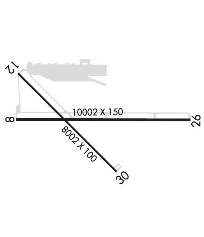
Runway Identifications
Runway Identification: 08/26Length: 10002 ft
Width: 150 ft
Surface: ASPHALT-GOOD CONDITION
Edge lights: Medium IntensityTreatment: GROOVED
Weight: PCN 49 /F/C/X/T
| | Runway: 08 | | Runway: 26 |
| Mag heading: | 78° | Mag heading: | 258° |
| Rwy Slope: | -.03% Down | Rwy Slope: | .03% Up |
| Approach: | | Approach: | |
| Pattern: | Right Traffic | Pattern: | Left Traffic |
| Markings: | PRECISION INSTRUMENT | Markings: | PRECISION INSTRUMENT |
| Marking Condition: | GOOD | Marking Condition: | GOOD |
| Arresting Dev: | | Arresting Dev: | |
| Lat & Long: | N4043.1 W11402.6 | Lat. & Long.: | N4043.1 W11400.4 |
| Elev: | 4229.7 ft. MSL | Elev: | 4226.4 ft. MSL |
| TCH: | 40 ft. AGL | TCH: | 50 ft. AGL |
| Visual Glide Path: | 3.00 degrees | Visual Glide Path: | 3.00 degrees |
| Displaced Threshold: | No | Displaced Threshold: | No |
| Touchdown Zone: | YES | Touchdown Zone: | YES |
| Touchdown Elev.: | 4230.2 feet | Touchdown Elev.: | 4226.6 feet |
| Visual Glide Slope: | 4-Light PAPI on LEFT side of Runway | Visual Glide Slope: | 4-Light PAPI on LEFT side of Runway |
| RVR Equipment: | | RVR Equipment: | |
| RVV Equipment: | NO | RVV Equipment: | NO |
| Approach Lights: | | Approach Lights: | |
| REIL: | YES | REIL: | YES |
| Centerline Lights: | NO | Centerline Lights: | NO |
| Touchdown lights: | NO | Touchdown lights: | NO |
| Runway Category: | Runway with a Non-precision Approach having visibility minimums greater than 3/4 mile | Runway Category: | Runway with a Non-precision Approach having visibility minimums greater than 3/4 mile |
| Declared Distances: | TORA:10002' TODA:10002' ASDA:10002' LDA:10002' | Declared Distances: | TORA:10002' TODA:10002' ASDA:10002' LDA:10002' |
Runway Identification: 12/30Length: 8002 ft
Width: 100 ft
Surface: ASPHALT-FAIR CONDITION
Edge lights: Medium IntensityTreatment: GROOVED
Weight: PCN 73 /F/C/X/T
| | Runway: 12 | | Runway: 30 |
| Mag heading: | 123° | Mag heading: | 303° |
| Rwy Slope: | -.15% Down | Rwy Slope: | .15% Up |
| Approach: | | Approach: | |
| Pattern: | Right Traffic | Pattern: | Left Traffic |
| Markings: | NONPRECISION INSTRUMENT | Markings: | NONPRECISION INSTRUMENT |
| Marking Condition: | GOOD | Marking Condition: | GOOD |
| Arresting Dev: | | Arresting Dev: | |
| Lat & Long: | N4043.6 W11402.6 | Lat. & Long.: | N4042.6 W11401.4 |
| Elev: | 4236.7 ft. MSL | Elev: | 4224.3 ft. MSL |
| TCH: | | TCH: | 45 ft. AGL |
| Visual Glide Path: | | Visual Glide Path: | 3.00 degrees |
| Displaced Threshold: | No | Displaced Threshold: | No |
| Touchdown Zone: | YES | Touchdown Zone: | YES |
| Touchdown Elev.: | 4236.7 feet | Touchdown Elev.: | 4227.1 feet |
| Visual Glide Slope: | | Visual Glide Slope: | 4-Light PAPI on LEFT side of Runway |
| RVR Equipment: | | RVR Equipment: | |
| RVV Equipment: | NO | RVV Equipment: | NO |
| Approach Lights: | | Approach Lights: | |
| REIL: | YES | REIL: | YES |
| Centerline Lights: | NO | Centerline Lights: | NO |
| Touchdown lights: | NO | Touchdown lights: | NO |
| Runway Category: | Runway with a Visual Approach | Runway Category: | Runway with a Visual Approach |
| Declared Distances: | TORA:8002' TODA:8002' ASDA:8002' LDA:8002' | Declared Distances: | TORA:8002' TODA:8002' ASDA:8002' LDA:8002' |

