Click here for more info on on SMS!

KEMT

EL MONTE
EL MONTE
CA
Time Zone: Pacific
Lat: N 3405.2
Long: W 11802.1
Elev: 296
Var: -14
Longest Runway: 3995
Dept. ATIS: 118.75
Arr. ATIS: 118.75
AWOS: 118.75
Ground: 125.9
Tower: 121.2

FBO & Flight Services info for KEMT

FBOs: Update your Fuel Prices

  click here  
Our amenities & services include: aviation fuel, aircraft parking (hanger/ramp/tie down), passenger terminal/lounge, pilot's lounge/snooze room, executive transport, conference rooms, public transportation/car rentals, snacks/drinks/restaurant, free highspeed internet, pilot supplies and much more!
Ph: 626-208-3708 Fax: 626-575-6030 Freq: 122.95WebsiteE-Mail
                                   
Service
Jet
100LL
SAF
MoGas
Fuel Avail: Prist+ $0.25/gal. After-hour fees may apply for aircraft services after 8pm to 8am.
Full6.847.19    Last Update: 03/24/2024 15:56

Self        
Misc. Info: Single Point Fueling AvailableAddress: 4233 SANTA ANITA AVE SUITE 7   EL MONTE, CA 91731

LA COUNTY PUB WKSPh: 626-448-6129 Fax: 626-448-6179 Freq: 122.95
Service
Jet
100LL
SAF
MoGas
Full        Last Update: 03/26/2024 14:07  
Self  5.96    
 Address: 4233 SANTA ANITA AVE,   EL MONTE, CA 91731
AWOSPh: 626-444-1107
-
Freq: 118.75  
If you are an FBO, call 1-203-262-1700 to update your info or email: FltPlan.Advertising@garmin.com
Advertise your FBO on FltPlan.com

Runway & Approach Info for KEMT
Rwy
Length
Land Dist**
Approach*
  Rwy
Length
Land Dist**
Approach*
01
3995x75  3705'          
 
  
19
  3995x75  3354'          
 
 * only ILS, LOC, LDA, and SDF approaches to a specific runway are shown
** For any Declared Landing Distance Available, please see A/FD or Approach plates
Runway Weight Capability (lbs.) Help
Runway IDSingle WheelDouble WheelDouble Tandem WheelDual Double Wheel
01/1912,500N/AN/AN/A
These numbers are Advisory and are not limits.   The Airport Manager should have more accurate Weight Limits
Approach Charts
Approaches    
Current Weather/Notams
Customs Information Send updates to Support@FltPlan.com
Customs Not Available
Database effective 04/18/2024
Airport Diagram of KEMT
Airport Diagram might not be current.

Facility Name: SAN GABRIEL VALLEY
City Name: EL MONTE
County: LOS ANGELES
State abbrev: CA
State Name: CALIFORNIA
   
Ownership: PUBLICLY OWNED
Use: OPEN TO THE PUBLIC
Owner's Name: CO OF LOS ANGELES
Address: P O BOX 1460
 ALHAMBRA, CA 91803-1331
Owner's Phone: 626-300-4600; LA COUNTY CTC: PAUL MASELBAS, 626-300-4600 X4615.
  
Manager's Name: SALVATORE EULLOQUI
Address: 4233 SANTA ANITA AVE
 EL MONTE, CA 91731
Phone: 213-410-9689
   
FAA Region: WESTERN-PACIFIC
FAA Field Office: LAX


Sunrise / Sunset times for SAN GABRIEL VALLEY

DateSunriseSunset
04/18/24 Thursday6:1619:27
04/19/24 Friday6:1519:27
04/20/24 Saturday6:1419:28
04/21/24 Sunday6:1319:29
04/22/24 Monday6:1219:30
04/23/24 Tuesday6:1119:31
04/24/24 Wednesday6:0919:31
04/25/24 Thursday6:0819:32
04/26/24 Friday6:0719:33
04/27/24 Saturday6:0619:34
04/28/24 Sunday6:0519:34
04/29/24 Monday6:0419:35
04/30/24 Tuesday6:0319:36
05/01/24 Wednesday6:0219:37

Airport Facilities

Airport Attendance ScheduleCONTINUOUS
Airport Status OPERATIONAL (This Status can change at any time - please check NOTAMS)
Airport Lighting ScheduleWHEN ATCT CLSD ACTVT REIL RWY 19, MIRL RWY 01/19 - CTAF.
Airport Storage AvailableTie Downs
Extra Services AvailableAvionics, Charter, Flight Instruction, Aircraft Rental, Aircraft Sales, Annual Surveying
Wind IndicatorYES - (lighted)
Control TowerYES
CTAF Frequency121.200
Unicom Frequency122.950
Rotating Beacon ColorWG
Segmented CircleYES
Landing FeeNO

Airport Inspection Data

Airport InspectedSTATE - performed by STATE AERONAUTICAL PERSONNEL
Inspection Date08/16/2023

Airport Services

Type of Fuel AvailableGrade 100LL, JET A (freeze point -40C)
Airframe Repair ServiceMAJOR
Power Plant Repair ServiceMAJOR

Geographic Data

LatitudeN3405.2
LongitudeW11802.1 (ESTIMATED)
Arpt Elevation295ft (SURVEYED)
Magnetic Variation14E
1 miles Nof EL MONTE
Traffic Pattern Altitude
Sectional ChartLOS ANGELES

Aircraft Data

Operations (Reported)YearlyAvg. Daily
General Aviation Transient 3108985
General Aviation Local 56159154
Air Taxi 3241
Commerical 210
Commuter 00
Military 470
Aircraft based on Field
General Aviation Singles 87
General Aviation Multi 1
Jet Aircraft 0
General Aviation Helicopters 5
Military Aircraft 0
Gliders 0
Ultralights 0

FAA Services

FSS on field NO
FSS tie-in RIVERSIDE
FSS Phone 1-800-WX-BRIEF
Who issues Notams EMT
Notam D service at airport YES
ARTCC Name LOS ANGELES

Federal Status

Airport Certification
Aircraft Rescue & Firefighting IndexNone
Airport of EntryNo
Custom Landing RightsNo
Joint Civil/MilitaryNo
Military Landing rightsYES

Federal Agreements

NATIONAL PLAN OF INTEGRATED AIRPORT SYSTEMS (NPIAS)
GRANT AGREEMENTS UNDER FAAP/ADAP/AIP
ASSURANCES PURSUANT TO TITLE VI, CIVIL RIGHTS ACT OF 1964

Remarks

THIS AIRPORT HAS BEEN SURVEYED BY THE NATIONAL GEODETIC SURVEY.
REMAIN OVER PAVED CHANNEL ON CLIMB OUT TO SOUTH AND TO NORTH.
HEAVY BIRD ACTIVITY ON & INVOF ARPT.
LGTD WATER TWR 1 MI W-SW OF ARPT.
(E81) CNTR TWY LGTS ONLY.
NOISE ABATEMENT PROCEDURES IN EFFECT, CTC ARPT MANAGER FOR DETAILS.
FOR CLNC DEL WHEN ATCT CLSD CALL SOCAL APP (800) 448-3724.
Airport Communications & Frequencies:
ATIS Frequencies:   Hours(local) of Operation: CONTINUOUS
118.75
EL MONTE Tower Frequencies:   Hours(local) of operation: 0800-2000   
121.2
EL MONTE Ground Frequencies:
125.9
CTAF Frequency:
121.200
Unicom Frequency:
122.950
Remarks
  • DRG HRS EL MONTE TWR IS OPNL SOCAL APP PRVDS DEP CTL SVC ON 125.5; OTR HRS DEP CTL ON 121.2.
  • SOCAL Primary Approach Frequencies:  
    125.5 SW-NORTH
    349.0 SW-NORTH
    379.25 NE-EAST
    SOCAL Primary Departure Frequencies:  
    125.5 SW-NORTH
    349.0 SW-NORTH
    379.25 NE-EAST
    Class C Frequencies:
    127.0 NORTH-NE
    318.2 NORTH-NE
    379.25 NE-EAST
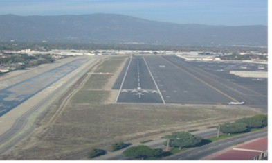
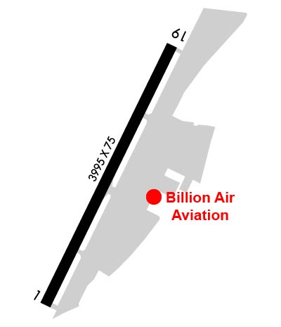
    Runway Identifications
    Runway Identification: 01/19
    Length: 3995 ft
    Width: 75 ft
    Surface: ASPHALT-GOOD CONDITION
    Edge lights: Medium Intensity

    Treatment: AGGREGATE FRICTION SEAL COAT

     Runway: 01   Runway: 19
    Mag heading: 11°Mag heading: 191°
    Rwy Slope: .35% UpRwy Slope: -.35% Down
    Approach: Approach:
    Pattern: Left TrafficPattern: Right Traffic
    Markings: BASICMarkings: BASIC
    Marking Condition: GOODMarking Condition: GOOD
    Arresting Dev: Arresting Dev:
    Lat & Long: N3404.9  W11802.3Lat. & Long.: N3405.5  W11801.9
    Elev: 281.8 ft. MSLElev: 295.6 ft. MSL
    TCH: 70 ft. AGLTCH: 37 ft. AGL
    Visual Glide Path: 4.57 degreesVisual Glide Path: 4.50 degrees
    Displaced Threshold: 290 feetDisplaced Threshold: 641 feet
    Touchdown Zone: YESTouchdown Zone: YES
    Touchdown Elev.: 293.3 feetTouchdown Elev.: 293.5 feet
    Visual Glide Slope: 2-Light PAPI on LEFT side of RunwayVisual Glide Slope: 2-Light PAPI on RIGHT side of Runway
    RVR Equipment: RVR Equipment:
    RVV Equipment: NORVV Equipment: NO
    Approach Lights: Approach Lights:
    REIL: NOREIL: YES
    Centerline Lights: NOCenterline Lights: NO
    Touchdown lights: NOTouchdown lights: NO
    Runway Category: Runway with a Visual ApproachRunway Category: Runway with a Visual Approach
    Declared Distances: TORA:3504' TODA:3995' ASDA:3755' LDA:3465'Declared Distances: TORA:3995' TODA:3995' ASDA:3995' LDA:3354'
    Obstructions: POLEObstructions: POLE
    Marked: NOT Marked/LightedMarked: NOT Marked/Lighted
    Clearance slope: 8:1; APCH RATIO 35:1 TO DSPLCD THR; APCH RATIO 33:1 TO DSPLCD THR OVER +45' PLINE OB 1490' FM DSPLCD THR.Clearance slope: 20:1; APCH RATIO 48:1 TO DSPLCD THR.
    Obstruction height: 18 feet AGLObstruction height: 30 feet AGL
    Dist. from runway: 350 feetDist. from runway: 800 feet
    Centerline offset: 85 right of centerlineCenterline offset: 205 feet left of centerline
    Comments: RWY 01 +6 FT FENCE 120 FT R OF CNTRLN; +6 FT FENCE 120 FT LEFT & PARALLEL TO CNTRLN 0-200 FT FM END OF RY.Comments: +2 FT FENCE 75 FT RIGHT OF CNTRLN AT THR TO 0 FT RIGHT OF CNTRLN AT 200 FT.
    C:9/P: