Click here for more info on on SMS!

KEMP

EMPORIA MUNI
EMPORIA
KS
Time Zone: Central
Lat: N 3819.8
Long: W 09611.4
Elev: 1208
Var: -05
Longest Runway: 5005
AWOS: 126.12
CTAF: 122.8

FBO & Flight Services info for KEMP

FBOs: Update your Fuel Prices
Providing high quality fuel and services to you and your customers, from Phillips 66 Aviation.
Ph: 620-343-5600 Fax: 620-343-5609 Freq: 122.8WebsiteE-Mail
                   
Service
Jet
100LL
SAF
MoGas
Fuel Avail: 24hr self serve on 100LL and Mo-gas(91-octane). All prices include tax.
Full4.955.45    Last Update: 04/13/2024 15:28

Self  5.25  4.65
Misc. Info: $0.10 discount for cash (full service only), Also, Discounts for purchases over 1,000 gallonsAddress: 1005 COUNTY RD 120,   EMPORIA, KS 66801

ASOSPh: 620-343-3733
-
Freq: 126.12  
If you are an FBO, call 1-203-262-1700 to update your info or email: FltPlan.Advertising@garmin.com
Advertise your FBO on FltPlan.com

Runway & Approach Info for KEMP
Rwy
Length
Land Dist**
Approach*
  Rwy
Length
Land Dist**
Approach*
01
5005x100  5005'          
 
  
19
  5005x100  5005'          
 
06
3881x300  3881'          
 
  
24
  3881x300  3881'          
 
 * only ILS, LOC, LDA, and SDF approaches to a specific runway are shown
** For any Declared Landing Distance Available, please see A/FD or Approach plates
Runway Weight Capability (lbs.) Help
Runway IDSingle WheelDouble WheelDouble Tandem WheelDual Double Wheel
01/1930,00045,000N/AN/A
06/24N/AN/AN/AN/A
These numbers are Advisory and are not limits.   The Airport Manager should have more accurate Weight Limits
Approach Charts
Approaches    
Current Weather/Notams
Customs Information Send updates to Support@FltPlan.com
Customs Not Available
Database effective 05/16/2024
Airport Diagram of KEMP
Airport Diagram might not be current.

Facility Name: EMPORIA MUNI
City Name: EMPORIA
County: LYON
State abbrev: KS
State Name: KANSAS
   
Ownership: PUBLICLY OWNED
Use: OPEN TO THE PUBLIC
Owner's Name: CITY OF EMPORIA; CITY MGR, MARK MCANARNEY
Address: P O BOX 928
 EMPORIA, KS 66801
Owner's Phone: 620-342-5105
  
Manager's Name: KEN ADAMS
Address: 1005 COUNTY RD 120
 EMPORIA, KS 66801
Phone: 620-343-5600
   
FAA Region: CENTRAL
FAA Field Office: NONE


Sunrise / Sunset times for EMPORIA MUNI

DateSunriseSunset
04/22/24 Monday6:3820:09
04/23/24 Tuesday6:3720:09
04/24/24 Wednesday6:3620:10
04/25/24 Thursday6:3420:11
04/26/24 Friday6:3320:12
04/27/24 Saturday6:3220:13
04/28/24 Sunday6:3120:14
04/29/24 Monday6:2920:15
04/30/24 Tuesday6:2820:16
05/01/24 Wednesday6:2720:17
05/02/24 Thursday6:2620:18
05/03/24 Friday6:2520:19
05/04/24 Saturday6:2420:20
05/05/24 Sunday6:2320:21

Airport Facilities

Airport Attendance ScheduleMAR-OCT 7 Days A Week 0730-1800, NOV-FEB 7 Days A Week 0730-1730
Airport Status OPERATIONAL (This Status can change at any time - please check NOTAMS)
Airport Lighting ScheduleACTVT PAPI & REIL RY 01/19 - CTAF. ACTVT MIRL RY 01/19 AFT 1800 - CTAF.
Airport Storage AvailableTie Downs, Hanger
Extra Services AvailableFlight Instruction, Aircraft Rental, Aircraft Sales
Wind IndicatorYES - (lighted)
Control TowerNO
CTAF Frequency122.800
Unicom Frequency122.800
Rotating Beacon ColorWG
Segmented CircleYES
Landing FeeNO

Airport Inspection Data

Airport InspectedSTATE - performed by STATE AERONAUTICAL PERSONNEL
Inspection Date09/21/2022

Airport Services

Type of Fuel AvailableGrade 100LL, JET A (freeze point -40C)MOGAS; -A JET-A AVBL ON REQUEST.; -1024 HR FUEL AVBL FOR MOGAS & 100LL.
Airframe Repair ServiceNONE
Power Plant Repair ServiceNONE

Geographic Data

LatitudeN3819.8
LongitudeW09611.4 (ESTIMATED)
Arpt Elevation1207ft (SURVEYED)
Magnetic Variation05E
4 miles Sof EMPORIA
Traffic Pattern Altitude
Sectional ChartKANSAS CITY

Aircraft Data

Operations (Reported)YearlyAvg. Daily
General Aviation Transient 900025
General Aviation Local 805022
Air Taxi 1000
Commerical 00
Commuter 00
Military 5001
Aircraft based on Field
General Aviation Singles 34
General Aviation Multi 3
Jet Aircraft 1
General Aviation Helicopters 3
Military Aircraft 0
Gliders 0
Ultralights 0

FAA Services

FSS on field NO
FSS tie-in WICHITA
FSS Phone 1-800-WX-BRIEF
Who issues Notams EMP
Notam D service at airport YES
ARTCC Name KANSAS CITY

Federal Status

Airport Certification
Aircraft Rescue & Firefighting IndexNone
Airport of EntryNo
Custom Landing RightsNo
Joint Civil/MilitaryNo
Military Landing rightsYES

Federal Agreements

NATIONAL PLAN OF INTEGRATED AIRPORT SYSTEMS (NPIAS)
GRANT AGREEMENTS UNDER FAAP/ADAP/AIP
ASSURANCES PURSUANT TO TITLE VI, CIVIL RIGHTS ACT OF 1964

Remarks

THIS AIRPORT HAS BEEN SURVEYED BY THE NATIONAL GEODETIC SURVEY.
ULTRALIGHT ACTVTY ON & INVOF ARPT.
ASOS MAST 27 FT AGL LCTD APRXLY 700 FT W OF RY 01/19 & 1,150 FT N OF AER 01.
WINDSOCK AT SEGMENTED CIRCLE NOT LIGHTED. WINDSOCK LIGHTED APRXLY 250 FT E OF RY 1/19 & 1000 FT S OF AER 19.
33 FT TREE OUTSIDE OF AND ADJ TO APCH SFC 100 FT FRM RWY 24 THLD.
FOR CD IF UNA TO CTC ON FSS FREQ, CTC KANSAS CITY ARTCC AT 913-254-8508.
RWY 01/1 9 LINE OF SIGHT BETWEEN RWY ENDS OBSTRUCTED.
RWY 06/2 4 SOFT WHEN WET.
RWY 06/2 4 1SOFT WHEN WET. CENTER 60 FT OF WIDTH IN GOOD CONDITION.
Airport Communications & Frequencies:
CTAF Frequency:
122.800
Unicom Frequency:
122.800
Remarks
  • APCH/DEP CTL SVC PRVDD BY KANSAS CITY ARTCC (ZKC) ON FREQS 127.725/270.25 (EMPORIA RCAG).
  • Runway Identifications
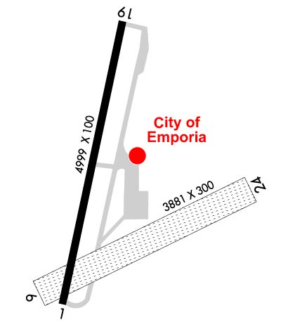
    Runway Identification: 01/19
    Length: 5005 ft
    Width: 100 ft
    Surface: CONCRETE ASPHALT-GOOD CONDITION
    Edge lights: Medium Intensity

    Treatment: NONE
    Weight: PCN 11 /F/C/X/U

     Runway: 01   Runway: 19
    Mag heading: Mag heading: 187°
    Rwy Slope: -.23% DownRwy Slope: .23% Up
    Approach: Approach:
    Pattern: Left TrafficPattern: Left Traffic
    Markings: NONPRECISION INSTRUMENTMarkings: NONPRECISION INSTRUMENT
    Marking Condition: GOODMarking Condition: GOOD
    Arresting Dev: Arresting Dev:
    Lat & Long: N3819.5  W09611.6Lat. & Long.: N3820.3  W09611.4
    Elev: 1204.4 ft. MSLElev: 1192.9 ft. MSL
    TCH: 41 ft. AGLTCH: 37 ft. AGL
    Visual Glide Path: 3.00 degreesVisual Glide Path: 3.00 degrees
    Displaced Threshold: NoDisplaced Threshold: No
    Touchdown Zone: YESTouchdown Zone: YES
    Touchdown Elev.: 1207.7 feetTouchdown Elev.: 1207.7 feet
    Visual Glide Slope: 4-Light PAPI on LEFT side of RunwayVisual Glide Slope: 4-Light PAPI on RIGHT side of Runway
    RVR Equipment: RVR Equipment:
    RVV Equipment: NORVV Equipment: NO
    Approach Lights: Approach Lights:
    REIL: YESREIL: YES
    Centerline Lights: NOCenterline Lights: NO
    Touchdown lights: NOTouchdown lights: NO
    Runway Category: Runway with a Non-precision Approach having visibility minimums greater than 3/4 mileRunway Category: Runway with a Non-precision Approach having visibility minimums greater than 3/4 mile
    Declared Distances: Declared Distances:
    Runway Identification: 06/24
    Length: 3881 ft
    Width: 300 ft
    Surface: GRASS-FAIR CONDITION
    Edge lights:

    Treatment: NONE

     Runway: 06   Runway: 24
    Mag heading: 60°Mag heading: 240°
    Rwy Slope: -.08% DownRwy Slope: .08% Up
    Approach: Approach:
    Pattern: Left TrafficPattern: Left Traffic
    Markings: NONSTANDARDMarkings: NONSTANDARD
    Marking Condition: RY ENDS & EDGES MKD WITH ORANGE & WHITE CORRUGATED PANELS.Marking Condition: RY ENDS & EDGES MKD WITH ORANGE & WHITE CORRUGATED PANELS.
    Arresting Dev: Arresting Dev:
    Lat & Long: N3819.6  W09611.7Lat. & Long.: N3819.9  W09610.9
    Elev: 1204.5 ft. MSLElev: 1201.4 ft. MSL
    TCH: TCH:
    Visual Glide Path: Visual Glide Path:
    Displaced Threshold: NoDisplaced Threshold: No
    Touchdown Zone: YESTouchdown Zone: YES
    Touchdown Elev.: 1206.9 feetTouchdown Elev.: 1205.5 feet
    Visual Glide Slope: Visual Glide Slope:
    RVR Equipment: RVR Equipment:
    RVV Equipment: NORVV Equipment: NO
    Approach Lights: Approach Lights:
    REIL: NOREIL: NO
    Centerline Lights: NOCenterline Lights: NO
    Touchdown lights: NOTouchdown lights: NO
    Runway Category: Runway with a Visual ApproachRunway Category: Runway with a Visual Approach
    Declared Distances: Declared Distances:
    C:8/P: